System requirements, installation, & working with the code
Before contributing to OpenStreetMap using the ArcGIS Desktop environment, please read the assumptions below.
- Use of the ArcGIS Editor for OpenStreetMap assumes that you are familiar with the OpenStreetMap site and are a member of its community. If not, then you should 1) spend some time on the OpenStreetMap wiki page, 2) create a user account, and 3) read the Map Making Overview page.
- Remember that you are responsible for any licensing associated with the edits you contribute to OSM. If there is any doubt that what you are about to contribute is under a license, you should wait and confirm that you can post the edit before doing so.
- Firsthand knowledge of the area you are mapping is much valued in the OpenStreetMap community. If you know there is a contribution that you are uniquely qualified to make (for example, an edit to features in your town of residence), that is a great edit to contribute.
Important: Read First!
- If you have an earlier version of ArcGIS Editor for OSM installed, you should uninstall the earlier version before installing a newer release. Do not install a newer release on top of an existing release, the installation will not be successful.
- Note! Through the ArcGIS for Home Use Program, users can purchase a non-commercial license for ArcGIS for Desktop that includes many extensions for US$100/yr.
- ArcGIS 10.0, 10.1, or 10.2 for Desktop. Note: ArcGIS for Desktop must be installed before the ArcGIS Editor for OpenStreetMap can be installed, and you should use the version of the ArcGIS Editor for OpenStreetMap that corresponds with your ArcGIS for Desktop environment.
- ArcGIS 10.1 for Desktop or ArcGIS 10.2 for Desktop.
- ArcGIS Background Geoprocessing for Desktop 10.1 sp1 or 10.2
- Note: ArcGIS for Desktop and the Background Geoprocessing for Desktop must be installed before the ArcGIS Editor for OpenStreetMap Desktop Component with Background Geoprocessing can be installed.
For the prototype server component requirements, see Arcgis editor for osm feature service
Important: If you have an earlier version of ArcGIS Editor for OSM installed, you should uninstall the earlier version before installing a newer release
When you downloaded the ArcGIS Editor for OSM version package, the .zip file contains subfolders with setup.exe installers:
- ArcGIS_Editor_OSM_10_xDesktop: Use this for installing the ArcGIS Editor for OSM Desktop Component, per the "Desktop Component for 10.x" instructions below.
- ArcGIS_Editor_OSM_10_xDesktop_64_BackgroundGP: Use this for installing the ArcGIS Editor for OpenStreetMap Desktop Component with Background Geoprocessing, per the "Desktop Component for 10.x with Background Geoprocessing" instructions below.
To install the ArcGIS Editor for OSM Desktop component on ArcGIS 10.x, run the setup.exe in the "ArcGIS_Editor_OSM_10_Desktop" folder. Accept the license, and then choose an installation directory. Continue to click through the wizard, and then click Finish at the end. After installation, a page will launch with instructions for how to get started with the Desktop tools. After installation of the Desktop component, three items are installed to your ArcGIS Desktop environment:
- A set of geoprocessing tools and models to download, extract, and upload vector data from and to the OpenStreetMap server.
- Customizations to the core editor environment in ArcMap to handle the OpenStreetMap tags inside the core Esri software.
- A conflict editor user interface to similar to the Reconcile Version tool for enterprise geodatabases.
Desktop Component for 10.x with Background Geoprocessing
The installation instructions and installed components of the ArcGIS Editor for OpenStreetMap Desktop Component with Background Geoprocessing is exactly the same as those for the "ArcGIS_Editor_OSM_10_Desktop", except that you will run the setup.exe in the "ArcGIS_Editor_OSM_10_Desktop_64_BackgroundGP" folder instead of the one in "ArcGIS_Editor_OSM_10_Desktop". See the "Desktop Component for 10.x" section above for installation instructions and installed components.
Configuration for Visual Studio 2010
- Read the web.config to run the server and make sure all paths are correct.
- Make sure you install Visual Studio 2010 Service Pack 1. You can install the latest version of Visual Studio from here: http://www.microsoft.com/web/gallery/install.aspx?appid=VWDorVS2010SP1Pack.
- OSMEditor32.sln - compile for the Desktop Component both for ArcGIS 10.0 and ArcGIS 10.1
- OSMEditor64.sln – compile for the 64bit classes used for the 10.1 Server component without having to deal with the web application side of it
- OSMEditorServer10_0.sln - compile for the Server Component at 10.0
- OSMEditorServer10_1.sln - compile for the Server Component at 10.1
Compiling for ArcGIS 10.0 Environments To compile for ArcGIS 10.0 environments, you will need to enter in specific inputs. Below, we describe compiling through the Visual Studio UI, and compiling from a command line
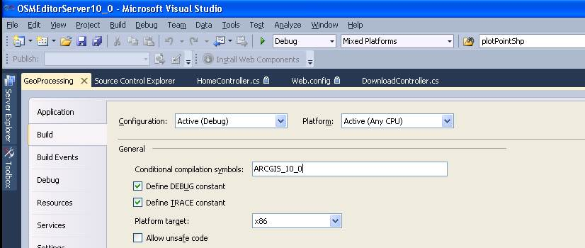
- Compiling from the Visual Studio UI (ArcGIS 10.0 environments) - Enter “ARCGIS_10_0” in the Conditional compilation symbols text box in the Build window for the GeoProcessing project properties, as shown below. Important: Do not check the project file into source control with this symbol set.
- Compiling from the Command Line (ArcGIS 10.0 environments)
Back to: Documentation