.. autofunction:: basinmaker.basinmaker.postprocess.Select_Subregion_Of_Routing_Structure( path_output_folder,routing_product_folder,gis_platform,most_down_stream_subbasin_ids = [],most_up_stream_subbasin_ids = [])
.. autofunction:: basinmaker.basinmaker.postprocess.Remove_Small_Lakes(path_output_folder,routing_product_folder,gis_platform,connected_lake_area_thresthold = -1,non_connected_lake_area_thresthold = -1,selected_lake_ids=[],area_thresthold = 0.009)
.. autofunction:: basinmaker.basinmaker.postprocess.Decrease_River_Network_Resolution(path_output_folder,routing_product_folder,gis_platform,minimum_subbasin_drainage_area,area_thresthold)
.. autofunction:: basinmaker.basinmaker.postprocess.Add_Point_Of_Interest_Sites_In_Routing_Product(path_output_folder,routing_product_folder,gis_platform,clean_exist_pois,area_thresthold)
.. autofunction:: basinmaker.basinmaker.postprocess.Generate_HRUs(path_output_folder,gis_platform,path_subbasin_polygon,path_landuse_info,path_soil_info,path_veg_info,prjected_epsg_code='EPSG:3573',path_connect_lake_polygon="#",path_non_connect_lake_polygon="#",path_landuse_polygon='#',path_soil_polygon="#",path_vegetation_polygon="#",path_other_polygon_1="#",area_ratio_thresholds = [0,0,0],path_to_dem = "#")
.. autofunction:: basinmaker.basinmaker.postprocess.Generate_Raven_Model_Inputs(path_output_folder,path_hru_polygon,aspect_from_gis,model_name="test",subbasingroup_nm_channel=["Allsubbasins"],subbasingroup_length_channel=[-1],subbasingroup_nm_lake=["AllLakesubbasins"],subbasingroup_area_lake=[-1])
In order to fully delineate a lake-river routing network from scratch, users need to sequentially apply five BasinMaker functions (ND1 to ND5) described in this section.
The overview of the workflow is summarized in the Figure below.
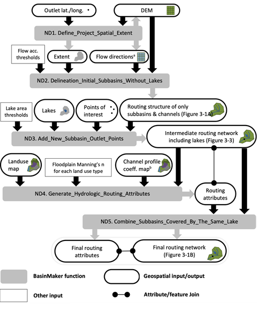
Figure Caption: This is Figure 3 from han et al. (2023). Workflow, including inputs and outputs, of the BasinMaker network delineation mode functions for generating a hydrological routing network with lakes and rivers given a DEM and a lake polygon layer. Notes: 1. Flow direction raster dataset is optional user input here. 2. The channel profile coefficient map to define bankfull channel widths and depths across the extent can alternatively be replaced by coefficients that are constant across the spatial extent of the project.
.. autofunction:: basinmaker.basinmaker.delineate.Define_Project_Spatial_Extent(mode,path_to_dem_input,watershed_outlet_coordinates=[-1,-1],path_to_spatial_extent_polygon = '#',buffer_distance=0.0,path_to_hydrobasin_polygon='#',hydrobasin_id_of_watershed_outlet=-1)
.. autofunction:: basinmaker.basinmaker.delineate.Delineation_Initial_Subbasins_Without_Lakes(fac_thresold,mode = 'using_dem',path_flow_dirction_in = '#',max_memroy = 4096)
.. autofunction:: basinmaker.basinmaker.delineate.Add_New_Subbasin_Outlet_Points(path_lake_polygon = '#',lake_attributes=[],connected_lake_area_thresthold = 0,non_connected_lake_area_thresthold = 0,path_point_of_interest = '#',point_of_interest_attributes = [],max_memroy = 4096)
For those running BasinMaker with QGIS & GRASS, points of interest will be snapped by this function automatically to the closest delineated river channel and as such, no input layer preparation is strictly required. However, in our experience this auto-snapping approach is only modestly successful. Please inspect snapped results carefully. If users ensure that points of interest associated with lake levels are located within a lake polygon, then this function will include the point of interest at the lake (and lake subbasin) outlet.
For those running BasinMaker in ArcGIS pro, the user needs to carefully prepare the points of interest shapefile as input. Specifically, the location of each non-lake point of interest should be carefully snapped to the the appropriate eventual delineated river channel. To do this, we recommend users build a temporary channel raster and snap to that. We also recommend users ensure that points of interest associated with lake levels are located within a lake polygon. These POI will be ignored by this function and must be added separately from this function using the function called "Add_Point_Of_Interest_Sites_In_Routing_Product".
A robust new function that can help users automatically snap points of interest to delineated river channels/lakes is coming in the next version of BasinMaker.
.. autofunction:: basinmaker.basinmaker.delineate.Generate_Hydrologic_Routing_Attributes(path_output_folder,prjected_epsg_code = "EPSG:3573",path_bkfwidthdepth_polyline="#",bkfwd_attributes=[],k = -1,c=-1,path_landuse="#",path_landuse_and_manning_n_table="#",lake_attributes=[],point_of_interest_attributes=[])
.. autofunction:: basinmaker.basinmaker.delineate.Combine_Subbasins_Covered_by_The_Same_Lake(routing_product_folder,gis_platform="qgis")