

![]()

mregions2 offers a streamlined interface to access data from Marine
Regions in R for researchers, marine
scientists, and geospatial analysts seeking marine geographical
information
Marine Regions offers two key resources: the Marine Regions Gazetteer, a list of standardized marine place names with unique identifiers, and the Marine Regions Data Products, including popular features like the world maritime boundaries.
You can find detailed information in the articles online:
- Introduction to mregions2
- Why mregions and mregions2?
- Marine Regions Data Products Ontology
- mregions2 as RDF
You can install mregions2 with:
install.packages("mregions2", repos = "https://ropensci.r-universe.dev")Or install the development version of mregions2 from GitHub with:
# install.packages("devtools")
devtools::install_github("ropensci/mregions2", build_vignettes = TRUE)
Load the library with:
library(mregions2)The function mrp_view() requires two extra packages that are not
listed as Imports, hence they are not installed along with mregions2
but you must install yourself:
install.packages("leaflet")
install.packages("leaflet.extras2")
Some of the examples below use the pipe operator %>%. Install and load
magrittr:
# install.packages("magrittr")
library(magrittr)The Marine Regions Gazetteer is a standard list of marine georeferenced place names.
Gazetteer: a dictionary of geographical names.
https://www.thefreedictionary.com/gazetteer
You can search the Gazetteer in many ways:
Search by free text:
gaz_search("Belgian Part of the North Sea")
#> # A tibble: 1 × 9
#>   MRGID gazetteerSource      placeType latitude longitude preferredGazetteerName
#>   <int> <chr>                <chr>        <dbl>     <dbl> <chr>
#> 1 26567 "VLIZ (2020). Inter… Marine R…     51.5      2.70 Belgian part of the N…
#> # ℹ 3 more variables: preferredGazetteerNameLang <chr>, status <chr>,
#> #   accepted <int>
Search by unique identifier. See ?MRGID:
gaz_search(3293)
#> # A tibble: 1 × 14
#>   MRGID gazetteerSource    placeType latitude longitude minLatitude minLongitude
#>   <int> <chr>              <chr>        <dbl>     <dbl>       <dbl>        <dbl>
#> 1  3293 Flanders Marine I… EEZ           51.5      2.72        51.0         2.24
#> # ℹ 7 more variables: maxLatitude <dbl>, maxLongitude <dbl>, precision <dbl>,
#> #   preferredGazetteerName <chr>, preferredGazetteerNameLang <chr>,
#> #   status <chr>, accepted <int>
Search by location:
gaz_search(x = 2.927, y = 51.21551)
#> # A tibble: 54 × 14
#>    MRGID gazetteerSource   placeType latitude longitude minLatitude minLongitude
#>    <int> <chr>             <chr>        <dbl>     <dbl>       <dbl>        <dbl>
#>  1    14 (2001). The Time… Nation        50.5      4.48        49.5         2.55
#>  2    14 (2001). The Time… Nation        50.5      4.48        49.5         2.55
#>  3    14 (2001). The Time… Nation        50.5      4.48        49.5         2.55
#>  4    14 (2001). The Time… Nation        50.5      4.48        49.5         2.55
#>  5    14 (2001). The Time… Nation        50.5      4.48        49.5         2.55
#>  6    14 (2001). The Time… Nation        50.5      4.48        49.5         2.55
#>  7    20 SAIL              Province…     51.0      3.03        50.7         2.55
#>  8    20 SAIL              Province…     51.0      3.03        50.7         2.55
#>  9    20 SAIL              Province…     51.0      3.03        50.7         2.55
#> 10    20 SAIL              Province…     51.0      3.03        50.7         2.55
#> # ℹ 44 more rows
#> # ℹ 7 more variables: maxLatitude <dbl>, maxLongitude <dbl>,
#> #   preferredGazetteerName <chr>, preferredGazetteerNameLang <chr>,
#> #   status <chr>, accepted <int>, precision <dbl>
Search by place type:
gaz_search_by_type("EEZ")
#> # A tibble: 246 × 14
#>    MRGID gazetteerSource   placeType latitude longitude minLatitude minLongitude
#>    <int> <chr>             <chr>        <dbl>     <dbl>       <dbl>        <dbl>
#>  1  3293 Flanders Marine … EEZ           51.5      2.72        51.0         2.24
#>  2  5668 Flanders Marine … EEZ           53.6      4.19        51.3         2.54
#>  3  5669 Flanders Marine … EEZ           54.6      8.40        52.9         3.35
#>  4  5670 Flanders Marine … EEZ           40.9     19.1         39.6        18.3
#>  5  5672 Flanders Marine … EEZ           42.9     29.2         42.0        27.4
#>  6  5673 Flanders Marine … EEZ           43.4     15.6         41.6        13.0
#>  7  5674 Flanders Marine … EEZ           56.2      9.21        54.4         3.25
#>  8  5675 Flanders Marine … EEZ           58.8     23.0         57.6        20.4
#>  9  5676 Flanders Marine … EEZ           61.8     21.9         58.8        19.1
#> 10  5677 Flanders Marine … EEZ           46.1     -1.96        41.2        -9.88
#> # ℹ 236 more rows
#> # ℹ 7 more variables: maxLatitude <dbl>, maxLongitude <dbl>, precision <dbl>,
#> #   preferredGazetteerName <chr>, preferredGazetteerNameLang <chr>,
#> #   status <chr>, accepted <int>
Search by authortative source:
gaz_search_by_source("Flanders Marine Institute (VLIZ)")
#> # A tibble: 23 × 13
#>    MRGID gazetteerSource     placeType latitude longitude preferredGazetteerName
#>    <int> <chr>               <chr>        <dbl>     <dbl> <chr>
#>  1 62642 Seys, J.; Pint, S.… Sampling…     51.3      3.16 SW-Blankenberge-01
#>  2 62643 Seys, J.; Pint, S.… Sampling…     51.2      2.96 SW-Bredene-01
#>  3 62644 Seys, J.; Pint, S.… Sampling…     51.3      3.26 SW-Duinbergen-01
#>  4 62645 Seys, J.; Pint, S.… Sampling…     51.3      3.00 SW-De Haan-Vosseslag-…
#>  5 62646 Seys, J.; Pint, S.… Sampling…     51.3      3.24 SW-Heist-01
#>  6 62647 Seys, J.; Pint, S.… Sampling…     51.1      2.62 SW-Koksijde-01
#>  7 62648 Seys, J.; Pint, S.… Sampling…     51.2      2.81 SW-Middelkerke-01
#>  8 62649 Seys, J.; Pint, S.… Sampling…     51.2      2.71 SW-Nieuwpoort-01
#>  9 62650 Seys, J.; Pint, S.… Sampling…     51.1      2.69 SW-Oostduinkerke-01
#> 10 62651 Seys, J.; Pint, S.… Sampling…     51.2      2.94 SW-Oostende_Oosteroev…
#> # ℹ 13 more rows
#> # ℹ 7 more variables: preferredGazetteerNameLang <chr>, status <chr>,
#> #   accepted <int>, minLatitude <dbl>, minLongitude <dbl>, maxLatitude <dbl>,
#> #   maxLongitude <dbl>
The list of place types and sources are available with gaz_types() and
gaz_sources() respectively.
You can add the geometry of the Gazetteer entries with gaz_geometry():
# Get a record and turn into a sf object with geometry
gaz_search(3293) %>% gaz_geometry()
#> Simple feature collection with 1 feature and 14 fields
#> Geometry type: MULTIPOLYGON
#> Dimension:     XY
#> Bounding box:  xmin: 2.238333 ymin: 51.03976 xmax: 4.402039 ymax: 51.87611
#> Geodetic CRS:  WGS 84
#> # A tibble: 1 × 15
#>   MRGID gazetteerSource    placeType latitude longitude minLatitude minLongitude
#>   <int> <chr>              <chr>        <dbl>     <dbl>       <dbl>        <dbl>
#> 1  3293 Flanders Marine I… EEZ           51.5      2.72        51.0         2.24
#> # ℹ 8 more variables: maxLatitude <dbl>, maxLongitude <dbl>, precision <dbl>,
#> #   preferredGazetteerName <chr>, preferredGazetteerNameLang <chr>,
#> #   status <chr>, accepted <int>, the_geom <MULTIPOLYGON [°]>

# Or get only the geometry
gaz_geometry(3293, format = "sfc")
#> Geometry set for 1 feature
#> Geometry type: MULTIPOLYGON
#> Dimension:     XY
#> Bounding box:  xmin: 2.238333 ymin: 51.03976 xmax: 4.402039 ymax: 51.87611
#> Geodetic CRS:  WGS 84
#> MULTIPOLYGON (((4.242049 51.35397, 4.230735 51....
The entries of the Marine Regions Gazetteer are organized
hierarchically. You can browse this hierarchy up and down with
gaz_relations()
# Get all relations
gaz_search(3293) %>% gaz_relations()
#> # A tibble: 37 × 14
#>    MRGID gazetteerSource   placeType latitude longitude minLatitude minLongitude
#>    <int> <chr>             <chr>        <dbl>     <dbl>       <dbl>        <dbl>
#>  1  3293 Flanders Marine … EEZ           51.5      2.72        51.0         2.24
#>  2  2419 ASFA thesaurus    Sandbank…     51.5      2.58        NA          NA
#>  3  2420 ASFA thesaurus    Sandbank…     51.5      2.88        NA          NA
#>  4  2421 ASFA thesaurus    Sandbank…     51.3      2.64        NA          NA
#>  5    14 (2001). The Time… Nation        50.5      4.48        49.5         2.55
#>  6  2350 (1953). Limits o… IHO Sea …     56.4      2.74        51.0        -4.45
#>  7  4675 <NA>              Sandbank…     NA       NA           NA          NA
#>  8  2550 ASFA thesaurus    Coast         51.2      2.91        51.1         2.54
#>  9 17401 Aphia             Wreck         51.4      2.32        NA          NA
#> 10 17409 Aphia             Wreck         51.1      2.33        NA          NA
#> # ℹ 27 more rows
#> # ℹ 7 more variables: maxLatitude <dbl>, maxLongitude <dbl>, precision <dbl>,
#> #   preferredGazetteerName <chr>, preferredGazetteerNameLang <chr>,
#> #   status <chr>, accepted <int>

# Or get the relations directly
gaz_relations(3293)
#> # A tibble: 37 × 14
#>    MRGID gazetteerSource   placeType latitude longitude minLatitude minLongitude
#>    <int> <chr>             <chr>        <dbl>     <dbl>       <dbl>        <dbl>
#>  1  3293 Flanders Marine … EEZ           51.5      2.72        51.0         2.24
#>  2  2419 ASFA thesaurus    Sandbank…     51.5      2.58        NA          NA
#>  3  2420 ASFA thesaurus    Sandbank…     51.5      2.88        NA          NA
#>  4  2421 ASFA thesaurus    Sandbank…     51.3      2.64        NA          NA
#>  5    14 (2001). The Time… Nation        50.5      4.48        49.5         2.55
#>  6  2350 (1953). Limits o… IHO Sea …     56.4      2.74        51.0        -4.45
#>  7  4675 <NA>              Sandbank…     NA       NA           NA          NA
#>  8  2550 ASFA thesaurus    Coast         51.2      2.91        51.1         2.54
#>  9 17401 Aphia             Wreck         51.4      2.32        NA          NA
#> 10 17409 Aphia             Wreck         51.1      2.33        NA          NA
#> # ℹ 27 more rows
#> # ℹ 7 more variables: maxLatitude <dbl>, maxLongitude <dbl>, precision <dbl>,
#> #   preferredGazetteerName <chr>, preferredGazetteerNameLang <chr>,
#> # status <chr>, accepted <int>In addition to the Marine Regions Gazetteer, the Marine Regions Team creates and hosts geographical Data Products, being the most popular one the Marine Regions Maritime Boundaries.
An overview of all available products can be consulted with mrp_list
mrp_list
#> # A tibble: 21 × 8
#>    title                   namespace layer license citation doi   imis  abstract
#>    <chr>                   <chr>     <chr> <chr>   <chr>    <chr> <chr> <chr>
#>  1 Exclusive Economic Zon… MarineRe… eez   Creati… "Flande… http… http… "Versio…
#>  2 Maritime Boundaries (v… MarineRe… eez_… Creati… "Flande… http… http… "Versio…
#>  3 Territorial Seas (12 N… MarineRe… eez_… Creati… "Flande… http… http… "Versio…
#>  4 Contiguous Zones (24 N… MarineRe… eez_… Creati… "Flande… http… http… "Versio…
#>  5 Internal Waters (v3, w… MarineRe… eez_… Creati… "Flande… http… http… "Versio…
#>  6 Archipelagic Waters (v… MarineRe… eez_… Creati… "Flande… http… http… "Versio…
#>  7 High Seas (v1, world, … MarineRe… high… Creati… "Flande… http… http… "High S…
#>  8 Extended Continental S… MarineRe… ecs   Creati… "Flande… http… http… "This d…
#>  9 Extended Continental S… MarineRe… ecs_… Creati… "Flande… http… http… "This d…
#> 10 IHO Sea Areas (v3)      MarineRe… iho   Creati… "Flande… http… http… "World …
#> # ℹ 11 more rows
Their attributes are explained in the Marine Regions Data Products
Ontology
article,
or simply run mrp_ontology
mrp_ontology
#> # A tibble: 374 × 4
#>    layer colname    type   definition
#>    <chr> <chr>      <chr>  <chr>
#>  1 eez   mrgid      int    Marine Regions Geographic Identifier of the feature.…
#>  2 eez   geoname    string Name of the feature.
#>  3 eez   mrgid_ter1 int    Marine Regions Geographic Identifier of the territor…
#>  4 eez   pol_type   string Basis of creation or legal status of feature. One of…
#>  5 eez   mrgid_sov1 int    Marine Regions Geographic Identifier of the sovereig…
#>  6 eez   territory1 string Specific land area which directly relates to the fea…
#>  7 eez   iso_ter1   string ISO 3 code of the territory feature.
#>  8 eez   sovereign1 string State that claims jurisdiction over the territory.
#>  9 eez   mrgid_ter2 int    Marine Regions Geographic Identifier of the territor…
#> 10 eez   mrgid_sov2 int    Marine Regions Geographic Identifier of the sovereig…
#> # ℹ 364 more rows
You can visualize the Marine Regions Data Products with mrp_view(). It
opens an interactive leaflet::leaflet viewer.
mrp_view("eez")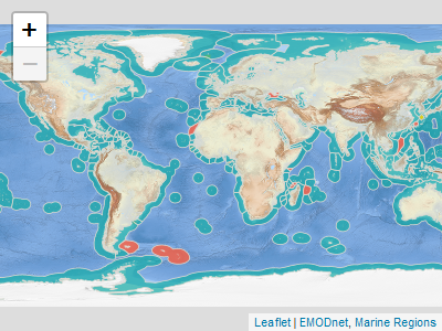
Or you can download and read the data products into R with mrp_get()
mrp_get("eez")You can specify the download path in the path argument:
mrp_get("eez", path = "path/to/data")Get to know more in the Get Started vignette.
The main purpose of Marine Regions is to serve as the geographical
backbone for the World Register of Marine Species (WoRMS), an
authoritative classification and catalogue of marine names. Here is a
list of R packages to access Marine taxonomical and biogeographic data
that can be combined with data from mregions2:
- worrms: World Register of Marine Species (WoRMS) Client.
- eurobis: Download data from EurOBIS using the LifeWatch/EMODnet-Biology Web Feature Services.
- robis: Ocean Biodiversity Information System (OBIS) Client.
- rgbif: Interface to the Global Biodiversity Information Facility API.
There are other R packages that allow to access other gazetteers and boundaries data. Here is a non-exhaustive list:
- geonames: Interface to the “Geonames” Spatial Query Web Service.
- osmdata: Import ‘OpenStreetMap’ Data as Simple Features or Spatial Objects.
- osmextract: Download and Import Open Street Map Data Extracts.
- rnaturalearth: World Map Data from Natural Earth.
citation("mregions2")
#> To cite package 'mregions2' in publications use:
#>
#>   Fernandez-Bejarano S, Pohl L (2023). _mregions2: Access Data from
#>   Marineregions.org: The Marine Regions Gazetteer and the Marine
#>   Regions Data Products_. <https://github.com/lifewatch/mregions2>.
#>
#> A BibTeX entry for LaTeX users is
#>
#>   @Manual{,
#>     title = {{mregions2}: Access Data from Marineregions.org: The Marine Regions Gazetteer and the Marine Regions Data Products},
#>     author = {Salvador Fernandez-Bejarano and Lotte Pohl},
#>     year = {2023},
#>     url = {https://github.com/lifewatch/mregions2},
#> }MIT. See LICENSE.md
This software is developed for scientific, educational and research purposes. It is not meant to be used for legal, economical (in the sense of exploration of natural resources) or navigational purposes. See the Marine Regions disclaimer for more information.
Please note that this package is released with a Contributor Code of Conduct. By contributing to this project, you agree to abide by its terms.