Export PDF layers from QGIS map composers #17962
Comments
|
Author Name: Jukka Rahkonen (Jukka Rahkonen) Feels the same as #17477 speaks about geopdf but it would be more safe to call it as geospatial pdf because GeoPDF is a trade mark. |
|
Author Name: Giovanni Manghi (@gioman) To note that QGIS "can" already export (from the canvas, not the composer) as geopdf: the format is supported in gdal/ogr used by qgis, so it would be possible to export using the "save as..." vector function or the translate tool in the raster menu. But as far as I can see the "geopdf" format is not listed in the gui comboboxes.
|
|
Author Name: Simon W (Simon W) Can we get a status on this or 8771? |
|
Author Name: Nyall Dawson (@nyalldawson) Simon - nothing to report, as far as I'm aware no one is currently tackling this issue. |
|
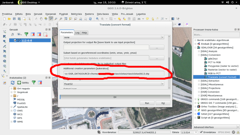
Author Name: Asier Sarasua (@asiersarasua) As GDAL 1.10 supports GeoPDF, I successfully exported a PDF with layers (a raster layer and a polyline vector layer) from Processing inserting a OGR_DATASOURCE parameter in the "Additional creation parameters" box to add the vector layer. However, it only exports vectors without style. I have to investigate more into this[1][2]. [1]http://www.gdal.org/frmt_pdf.html
|
|
Author Name: Giovanni Manghi (@gioman) Asier Sarasua wrote:
Hi, yes this is expected beside the lack of options in QGIS gui. The ticket is more about the possibility to export a map from the QGIS composer as geopdf. |
|
Author Name: Luca Delucchi (Luca Delucchi) Hi, I'm working on a plugin to create GeospatialPDF (not that real GeoPDF because is proprietary format) from raster and vector data loaded into QGIS, but not from QGIS composer. The plugin is close to be released (I hope in two/three weeks) and will have the following capabilities:
|
|
Author Name: James Wilson (James Wilson) If you want to make a Georeferenced PDF for Avenza: Set up your print composer, and export it as a georeferenced image |
|
Author Name: amedeo fadini (amedeo fadini) I'm also interested in this feature: the planned use case is to distribute a PDF map or atlas in PDF format and give to the final user the chance to print the whole map or only the layers of interest. |
|
Author Name: Giovanni Manghi (@gioman)
|
|
Implemented in 3.10 |
Author Name: Asier Sarasua (@asiersarasua)
Original Redmine Issue: 9362
Redmine category:map_composer/printing
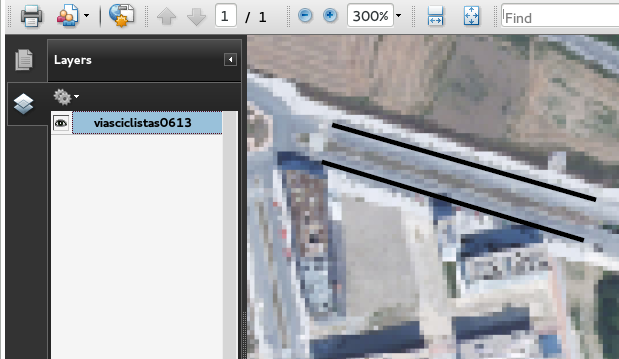
As in the attached image.
PDF layers are formally known as Optional Content Groups.
"They represent a collection of graphic objects that can be made visible or invisible. Any graphic content of the PDF can be made optional, including page contents, XObjects, and annotations." Reference:
http://livedocs.adobe.com/acrobat_sdk/9.1/Acrobat9_1_HTMLHelp/API_References/Acrobat_API_Reference/PD_Layer/PDOCG.html
This feature would give the ability to open a PDF (generated from the QGIS composer) in Acrobat and enable/disable the visibility of layers.
Related issue(s): #17477 (duplicates)
Redmine related issue(s): 8771
The text was updated successfully, but these errors were encountered: