Difficult to edit nodes of polygons close together #18673
Comments
|
Author Name: Patrick Dunford (@enzedrailmaps) Sample project and layers attached.
|
|
Author Name: Patrick Dunford (@enzedrailmaps) And another thing, I want someone to tell me what is happening here because this is incredibly frustrating as well... I have clicked on one vertice (node) and it decides to move two instead of one. This happens sometimes quite often regardless.
|
|
Author Name: Antonio Locandro (Antonio Locandro) Sorry, I don't see the red square but I am not able to confirm what you report, to edit nodes and select you have to click on the appropriate layer in the list of layers, I could move the nodes without issues and I couldn't reproduce. |
|
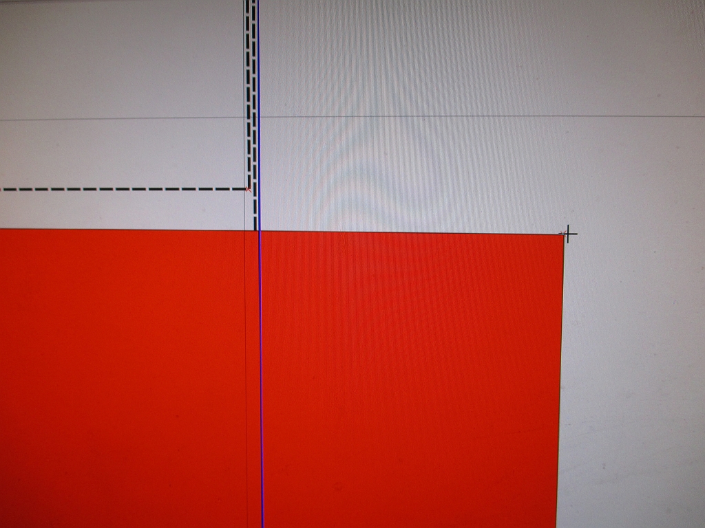
Author Name: Patrick Dunford (@enzedrailmaps) Uh??? Well here is another illustration. I have used the selection tool to select the polygon which is filled with red (the selection colour of my project). I now try to click on the top right corner (node) of that polygon. Instead of that, what is being selected is the line shown in blue which is the side of a different polygon. At the least it should be possible to select the nodes of the currently selected polygon, if there are several which are close together. |
|
Author Name: Patrick Dunford (@enzedrailmaps) The photo that was supposed to accompany the last submission.
|
|
Author Name: Giovanni Manghi (@gioman) Patrick Dunford wrote:
the project you attached is missing two layers that are probably necessary to understand better your point. A screencast would also probably help.
|
|
Author Name: Leyan Ouyang (Leyan Ouyang) Patrick Dunford wrote:
This happens if you click on the segment instead of the node. Then both extremities of the segment are selected and moved together. I often do that by mistake as well, I agree the UI is not very good. |
|
Author Name: Leyan Ouyang (Leyan Ouyang) I had a look at your shapefiles and I can't reproduce the issue. I agree with Giovanni that a screencast would be very useful to see where is the problem. edit: I think I see your problem: when a polygon has already been selected, you cannot select another one by clicking "too close" of the first one. However, this "too close" is not affected by the zoom, so can give counter-intuitive results. I will look into it. |
|
Author Name: Leyan Ouyang (Leyan Ouyang) The issue is due to rounding happening when selecting features and snapping nodes. In the short term, I would advise to choose a projected coordinate refrence system instead of WGS84 to work on such large scale data. This should solve your problems as you would be working in meters instead of degrees, giving more reasonable numbers to work with. If it is not possible, try to zoom out when selecting new features and nodes, this will help a bit. However, I agree that there are bugs in the way QGis deals with these level of zoom and and these small distances. If they are available, all QGis features should work as expected. |
|
Author Name: Patrick Dunford (@enzedrailmaps) Thanks that last response. |
|
Author Name: Giovanni Manghi (@gioman) Patrick Dunford wrote:
activate the reprojection in project properties and select a cartographic CRS, or use the "save as..." function to create copies of your layers in a projected CRS. I would suggest to close this ticket. |
|
Author Name: Giovanni Manghi (@gioman) Closing for lack of feedback.
|
|
Author Name: Giovanni Manghi (@gioman)
|
Author Name: Patrick Dunford (@enzedrailmaps)
Original Redmine Issue: 10234
Affected QGIS version: 2.2.0
Redmine category:digitising
If I am editing a layer that contains polygons close together it can be almost impossible to select the one I am trying to edit, when the Node tool is being used.
In the picture shown I have four polygons. The red one and the grey one are in the same layer - the red one has been selected for node editing. Yet try as I might I simply cannot get its nodes to show the selection rectangle, no matter where I click. The majority of the time, the selection will snap to the other polygon next to this one.
I can't see why it is that if I have used the selection tool to select a particular polygon, why I can't make the vertices of that polygon be selected for editing. Even when I click in the bottom right corner I am still selecting a vertice on the polygon in the top left hand corner !
All the snapping options have been looked at and tolerances set to zero but still getting the problem.
Related issue(s): #13811 (relates), #19362 (relates)
Redmine related issue(s): 3752, 11022
The text was updated successfully, but these errors were encountered: