Skip to content
New issue

Have a question about this project? Sign up for a free GitHub account to open an issue and contact its maintainers and the community.

By clicking “Sign up for GitHub”, you agree to our terms of service and privacy statement. We’ll occasionally send you account related emails.

Already on GitHub? Sign in to your account

WMS not working on master a625eeb (2.15.0-80) #22923

Closed
qgib opened this issue Jun 7, 2016 · 16 comments
Closed

WMS not working on master a625eeb (2.15.0-80) #22923

qgib opened this issue Jun 7, 2016 · 16 comments
Labels
Bug Either a bug report, or a bug fix. Let's hope for the latter! Data Provider Related to specific vector, raster or mesh data providers
Milestone

Comments

@qgib
Copy link
Contributor

qgib commented Jun 7, 2016

Author Name: Pedro Venâncio (Pedro Venâncio)
Original Redmine Issue: 14974
Affected QGIS version: master
Redmine category:web_services_clients/wms


WMS are not working on the master (qgis-dev 2.15.0-80 a625eeb OSGeo4W 64bits). With yesterday's master version, they were working very well.

The problem I see in the metadata properties is in the layer extent.

The WMS I'm using, uses a projected CRS, and it works ok in QGIS 2.14.3, with the following layer extent:

Layer Spatial Reference System
+proj=tmerc +lat_0=39.66825833333333 +lon_0=-8.133108333333334 +k=1 +x_0=0 +y_0=0 +ellps=GRS80 +towgs84=0,0,0,0,0,0,0 +units=m +no_defs
Layer Extent (layer original source projection)
71515.6121936073323013,99674.5072469547740184 : 100678.0292317192797782,150324.6242672884836793

Strangely, with today's QGIS master, it takes a geographic extent, although the CRS is projected, and it shows nothing in canvas:

Layer Spatial Reference System
+proj=tmerc +lat_0=39.66825833333333 +lon_0=-8.133108333333334 +k=1 +x_0=0 +y_0=0 +ellps=GRS80 +towgs84=0,0,0,0,0,0,0 +units=m +no_defs
Layer Extent (layer original source projection)
-8.1331932104725588,39.6686236708940925 : -8.1331892645531472,39.6686277518395016

As I said, with yesterday's master version it was working well. So it must have been caused by any recent change.


@qgib
Copy link
Contributor Author

qgib commented Jun 7, 2016

Author Name: Pedro Venâncio (Pedro Venâncio)


Loading the WMS with a geographic CRS (WGS84), which is also supported by the server, already shows the content on canvas. But it is very slow, as it is showing tile by tile, which was not the standard behaviour on 2.14.3 nor the yesterday's master behaviour.

@qgib
Copy link
Contributor Author

qgib commented Jun 7, 2016

Author Name: Nyall Dawson (@nyalldawson)


Should be fixed (d77a33) in tomorrow's build -


  • status_id was changed from Open to Closed
  • resolution was changed from to fixed/implemented

@qgib
Copy link
Contributor Author

qgib commented Jun 7, 2016

Author Name: Pedro Venâncio (Pedro Venâncio)


Thanks Nyall!

@qgib
Copy link
Contributor Author

qgib commented Jun 8, 2016

Author Name: Pedro Venâncio (Pedro Venâncio)


Hi Nyall,

I'm reopening this bug report, but I don't know if this is related with the same question fixed in d77a33.

The WMS continues to not show up on the canvas in QGIS master, and comes up with the wrong layer extent. But I realized the source of the problem.

I'm using mapserver as WMS server.

So, if I declare the CRS in the mapfile, pointing to a NTv2 grid file, like this:

PROJECTION
    "+init=pt:pttm06 +wktext"
END

in GetCapabilities I get:

    <Layer queryable="0" opaque="0" cascaded="0">
        <Name>Ortofotomapa_34cm_2014</Name>
        <Title>Ortofotomapa 34cm (voo 2014)</Title>
        <EX_GeographicBoundingBox>
            <westBoundLongitude>-7.30711</westBoundLongitude>
            <eastBoundLongitude>-6.94372</eastBoundLongitude>
            <southBoundLatitude>40.5624</southBoundLatitude>
            <northBoundLatitude>41.0166</northBoundLatitude>
        </EX_GeographicBoundingBox>
        <BoundingBox CRS="" minx="69950" miny="99950" maxx="100050" maxy="150050" />
        <Style>
          <Name>default</Name>
          <Title>default</Title>
          <LegendURL width="239" height="22">
             <Format>image/png</Format>
             <OnlineResource xmlns:xlink="http://www.w3.org/1999/xlink" xlink:type="simple" xlink:href=""/>
          </LegendURL>
        </Style>
    </Layer>

the CRS is empty, but the extent is correct.

With this configuration, QGIS 2.14.3 works great and load the WMS layer in all CRS that are provided by the server. QGIS master loads the layer without any error message, but it does not show anything in canvas. It only works if I choose EPSG:4326 in QGIS WMS provider.

Instead, if I declare the CRS by the EPSG code in mapfile

PROJECTION
    "init=epsg:3763"
END

the GetCapabilities shows

    <Layer queryable="0" opaque="0" cascaded="0">
        <Name>Ortofotomapa_34cm_2014</Name>
        <Title>Ortofotomapa 34cm (voo 2014)</Title>
        <EX_GeographicBoundingBox>
            <westBoundLongitude>-7.30711</westBoundLongitude>
            <eastBoundLongitude>-6.94372</eastBoundLongitude>
            <southBoundLatitude>40.5624</southBoundLatitude>
            <northBoundLatitude>41.0166</northBoundLatitude>
        </EX_GeographicBoundingBox>
        <BoundingBox CRS="EPSG:3763" minx="69950" miny="99950" maxx="100050" maxy="150050" />
        <Style>
          <Name>default</Name>
          <Title>default</Title>
          <LegendURL width="239" height="22">
             <Format>image/png</Format>
             <OnlineResource xmlns:xlink="http://www.w3.org/1999/xlink" xlink:type="simple" xlink:href=""/>
          </LegendURL>
        </Style>
    </Layer>

and QGIS master already shows the WMS layer in canvas.


  • status_id was changed from Closed to Reopened
  • assigned_to_id was configured as Nyall Dawson

@qgib
Copy link
Contributor Author

qgib commented Jun 12, 2016

Author Name: Christoph Candido (Christoph Candido)


The problem even exists in qgis-dev 2.15.0-85 f1ec121 (OSGeo4W x86).

The QGIS WMS Client only accepts CRS 4326 and 3857.
If we change the requested CRS to i.e. EPSG:31255 no getMap request is sent.

With EPSG:3857 and EPSG:4326 everything is fine.

@qgib
Copy link
Contributor Author

qgib commented Jun 13, 2016

Author Name: Even Rouault (@rouault)


@Christophe Could you paste or give a link to the GetCapabilities ?

@qgib
Copy link
Contributor Author

qgib commented Jun 13, 2016

Author Name: Nyall Dawson (@nyalldawson)


  • assigned_to_id removed Nyall Dawson

@qgib
Copy link
Contributor Author

qgib commented Jun 15, 2016

Author Name: Christoph Candido (Christoph Candido)


Even,

you point me in the right direction!

The problem lies in the "GetCapabilities" response.
There are only BoundingBox definitions for 4326,3857 and 900913 available for each layer.
Unfortunately, latest QGIS takes this into account. Old releases didn't pay attention.


  • 10018 was configured as getCapabilities.png

@qgib
Copy link
Contributor Author

qgib commented Jun 15, 2016

Author Name: Christoph Candido (Christoph Candido)


@even

Sorry, I was wrong.
After clearing the internal cache, everything works as expected, even with no explicit BoundingBox definitions.
The only difference to older versions: QGIS now limits the WMS layer to the EPSG area of use.
Is there any environment variable to prevent this?

@qgib
Copy link
Contributor Author

qgib commented Jun 15, 2016

Author Name: Christoph Candido (Christoph Candido)


Nope, i revise my last statement.
The problem is definitely with missing BoundingBox definitions in the GetCapabilities response!
If the BoundingBox definition is not available for a requested projection, the WMS layer is loaded but not displayed.

Can I disable the WMS area-of-use restriction with a local user setting?

@qgib
Copy link
Contributor Author

qgib commented Jun 16, 2016

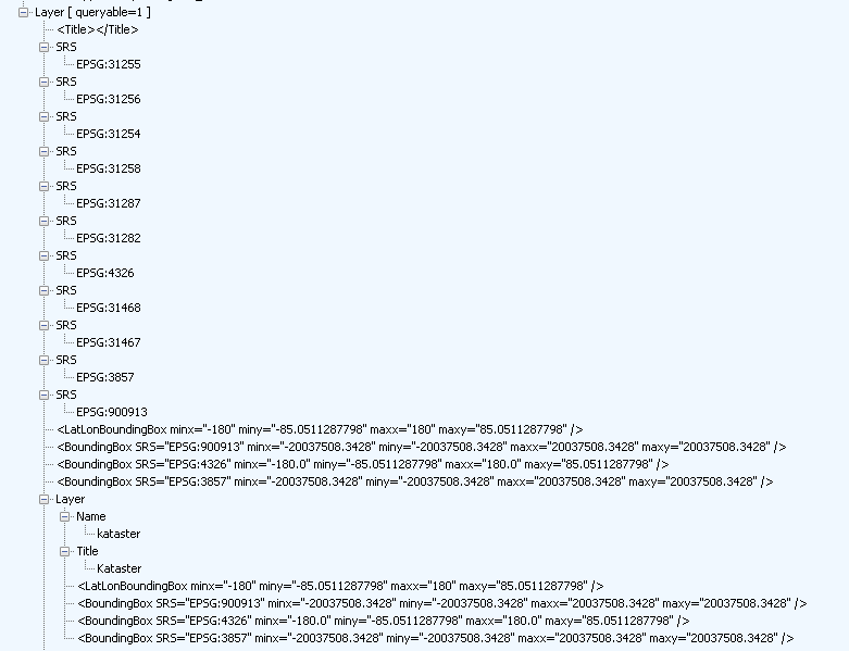
Author Name: Pedro Venâncio (Pedro Venâncio)


Hi Christoh,

From my investigation, I think the problem is in the explicit declaration of the BBox CRS, with the corresponding EPSG code.

If you see here

        <EX_GeographicBoundingBox>
            <westBoundLongitude>-7.30711</westBoundLongitude>
            <eastBoundLongitude>-6.94372</eastBoundLongitude>
            <southBoundLatitude>40.5624</southBoundLatitude>
            <northBoundLatitude>41.0166</northBoundLatitude>
        </EX_GeographicBoundingBox>
        <BoundingBox CRS="" minx="69950" miny="99950" maxx="100050" maxy="150050" />

        <EX_GeographicBoundingBox>
            <westBoundLongitude>-7.30711</westBoundLongitude>
            <eastBoundLongitude>-6.94372</eastBoundLongitude>
            <southBoundLatitude>40.5624</southBoundLatitude>
            <northBoundLatitude>41.0166</northBoundLatitude>
        </EX_GeographicBoundingBox>
        <BoundingBox CRS="EPSG:3763" minx="69950" miny="99950" maxx="100050" maxy="150050" />

the BBox extent is the same in both cases in GetCapabilities, but QGIS master only interprets the BBox correctly in the second case, except for WGS84, that works in every case.

@qgib
Copy link
Contributor Author

qgib commented Jun 22, 2016

Author Name: Giovanni Manghi (@gioman)


  • operating_system was changed from Windows to
  • resolution was changed from fixed/implemented to

@qgib
Copy link
Contributor Author

qgib commented Jun 22, 2016

Author Name: Jürgen Fischer (@jef-n)


  • subject was changed from WMS not working on master 2.15.0-80 to WMS not working on master a625eeb (2.15.0-80)

@qgib
Copy link
Contributor Author

qgib commented Jun 27, 2016

Author Name: Martin Dobias (@wonder-sk)


Pedro,

is it possible to access the WMS server somewhere so we can test it?


  • status_id was changed from Reopened to Feedback

@qgib
Copy link
Contributor Author

qgib commented Jun 30, 2016

Author Name: Martin Dobias (@wonder-sk)


Fixed in changeset "0409f5e30cfaab7a0baf2f127c4c30c68a65d29f".


  • status_id was changed from Feedback to Closed

@qgib
Copy link
Contributor Author

qgib commented Jun 30, 2016

Author Name: Martin Dobias (@wonder-sk)


(Thanks to Pedro who provided me with WMS server to replicate the problem)

@qgib qgib added Bug Either a bug report, or a bug fix. Let's hope for the latter! Data Provider Related to specific vector, raster or mesh data providers labels May 25, 2019
@qgib qgib added this to the Version 2.16 milestone May 25, 2019
@qgib qgib closed this as completed May 25, 2019
Sign up for free to join this conversation on GitHub. Already have an account? Sign in to comment
Labels
Bug Either a bug report, or a bug fix. Let's hope for the latter! Data Provider Related to specific vector, raster or mesh data providers
Projects
None yet
Development

No branches or pull requests

1 participant