Skip to content
New issue

Have a question about this project? Sign up for a free GitHub account to open an issue and contact its maintainers and the community.

By clicking “Sign up for GitHub”, you agree to our terms of service and privacy statement. We’ll occasionally send you account related emails.

Already on GitHub? Sign in to your account

Updating raster single-band min/max method does not update actual min/max #26593

Open
qgib opened this issue Apr 10, 2018 · 7 comments
Open

Updating raster single-band min/max method does not update actual min/max #26593

qgib opened this issue Apr 10, 2018 · 7 comments
Labels
Bug Either a bug report, or a bug fix. Let's hope for the latter! Rasters Related to general raster layer handling (not specific data formats) Symbology Related to vector layer symbology or renderers

Comments

@qgib
Copy link
Contributor

qgib commented Apr 10, 2018

Author Name: Dewey Dunnington (@paleolimbot)
Original Redmine Issue: 18705
Affected QGIS version: 3.0.0
Redmine category:osx_ui


When updating the min/max method for single band (pseudocolor and grayscale), updating the manual min/max values will change the method to "User defined", but changing the method type to something else (min/max, mean +/-) does not update the min/max values until the "Apply" or "OK" is clicked on the user dialog. Clicking "Classify" doesn't do anything. Is this intentional? I think there used to be a "calculate" button here? It took me a while to figure out the fix...


@qgib
Copy link
Contributor Author

qgib commented Apr 11, 2018

Author Name: Alessandro Pasotti (@elpaso)


Can you please check how (and if) it was working in 2.x?

If this is a regression introduced in 3.x, please flag it.

What is the expected behavior here?

I think that the "Classify" button should recalculate the values whenever pressed...


  • assigned_to_id was configured as Alessandro Pasotti

@qgib
Copy link
Contributor Author

qgib commented Apr 11, 2018

Author Name: Alessandro Pasotti (@elpaso)


Small update testing on Linux, if I manually change Min or Max values this is what happens:

  • User defined is automatically selected
  • The values are automatically recalculated

this looks like (another) OSX issue, sorry but I cannot help.


  • assigned_to_id removed Alessandro Pasotti

@qgib
Copy link
Contributor Author

qgib commented Apr 11, 2018

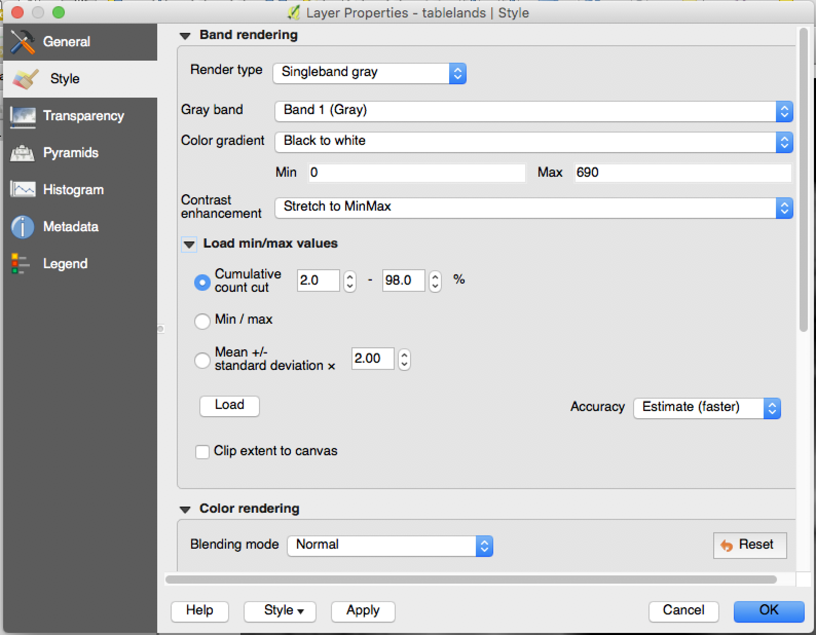
Author Name: Dewey Dunnington (@paleolimbot)


This is not an OSX issue, this is a QGIS 3 issue. Updating the min/max values manually will automatically change the min/max method type, but changing the min/max method type does not automatically change the min/max values unless the "Apply" or "OK" is clicked. In QGIS 2, there was a "Load" button that performed this operation. This is a problem for both grayscale and pseudocolor singleband representations.


  • assigned_to_id was configured as Alessandro Pasotti
  • 12595 was configured as Screen Shot 2018-04-11 at 1.52.21 PM.png

@qgib
Copy link
Contributor Author

qgib commented Apr 11, 2018

Author Name: Alessandro Pasotti (@elpaso)


  • assigned_to_id removed Alessandro Pasotti

@qgib
Copy link
Contributor Author

qgib commented Apr 11, 2018

Author Name: Alessandro Pasotti (@elpaso)


ok, got it.
The load button is gone.

Apparently by design:

commit 407991e
Author: nirvn nirvn.asia@gmail.com
Date: Tue Dec 27 14:43:26 2016 +0700

[ui] rename the min/max widget group box title
Since there is no more loading involved through
the min/max widget, rename it to:
"Min /max values settings"

@qgib
Copy link
Contributor Author

qgib commented Apr 11, 2018

Author Name: Dewey Dunnington (@paleolimbot)


No problem with a Load button that doesn't exist, provided that there is a way to change from a manually entered min/max to a calculated min/max. The "load" operation is fired when "Apply" is clicked, but could also be fired when the user changes any of the options for the Min/Max settings (e.g., different +/- standard deviation, change to min/max from user defined). At the very least, I feel like it should be fired when the user clicks "classify" in the pseudocolor section.

@qgib qgib added Bug Either a bug report, or a bug fix. Let's hope for the latter! Build/Install Related to compiling or installing QGIS labels May 25, 2019
@alexbruy alexbruy removed the Build/Install Related to compiling or installing QGIS label May 1, 2020
@gioman gioman added Rasters Related to general raster layer handling (not specific data formats) Symbology Related to vector layer symbology or renderers labels Jan 3, 2021
@Pedro-Murteira
Copy link

Still valid on QGIS 3.22.3. on Windows 10.

Sign up for free to join this conversation on GitHub. Already have an account? Sign in to comment
Labels
Bug Either a bug report, or a bug fix. Let's hope for the latter! Rasters Related to general raster layer handling (not specific data formats) Symbology Related to vector layer symbology or renderers
Projects
None yet
Development

No branches or pull requests

4 participants