Skip to content
New issue

Have a question about this project? Sign up for a free GitHub account to open an issue and contact its maintainers and the community.

By clicking “Sign up for GitHub”, you agree to our terms of service and privacy statement. We’ll occasionally send you account related emails.

Already on GitHub? Sign in to your account

Issue in Union of two intersecting polygons with non-zero areas returns empty #1354

Closed
stalhabukhari opened this issue Mar 31, 2022 · 9 comments

Comments

@stalhabukhari
Copy link

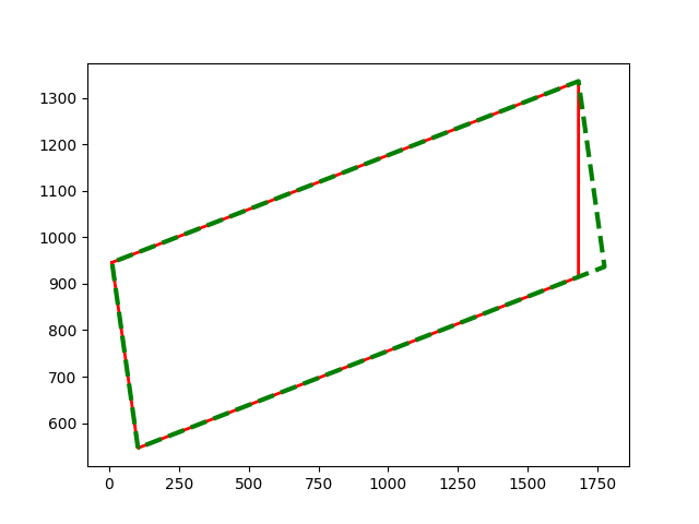
I encountered few rare cases where the ops.unary_union and Polygon.union methods misbehave, returning an empty polygon.

Expected behavior and actual behavior.

In the scenario shown below, there are two polygons with non-zero areas and calculating their union results in an empty polygon with zero area. Instead, their union should have roughly been the larger polygon (since one is a subset of the other) and hence should have a non-zero area.

from shapely.geometry import Polygon
from shapely.ops import unary_union

check1 = Polygon([[10.38343007464573, 945.7998193082476], [1682.0, 1335.7904894634128], [1682.0, 914.7369958740137],
                  [103.54509436006265, 546.4810826847133], [10.38343007464573, 945.7998193082476]])
check2 = Polygon(
    [[103.54509436006265, 546.4810826847133], [10.383430074645716, 945.7998193082476], [1682.0, 1335.7904894634128],
     [1775.161664285417, 936.4717528398785], [103.54509436006265, 546.4810826847133]])

print(check1.area, check2.area, check1.intersects(check2), unary_union([check1, check2]).area,
      check1.union(check2).area)

Output:

684226.9746010096 703839.9967089986 True 0.0 0.0

Plot:
image

Operating system

Ubuntu 20.04.3 (focal)

Shapely version and provenance

1.8.1.post1 installed from PyPI using pip

@jorisvandenbossche
Copy link
Member

@stalhabukhari thanks for the report!

I can confirm this issue using GEOS 3.10.2 (didn't test master). The union gives an empty polygon, while for example the intersection seems to work correctly:

>>> check1.intersection(check2).wkt
'POLYGON ((1682 1335.7904894634128, 1682 914.7369958740137, 103.54509436006265 546.4810826847133, 10.38343007464573 945.7998193082476, 1682 1335.7904894634128))'

cc @dr-jts

@jorisvandenbossche
Copy link
Member

A direct geos reproducer using geosop:

# intersection
$ geosop -a "POLYGON ((10.38343007464573 945.7998193082476, 1682 1335.7904894634128, 1682 914.7369958740137, 103.54509436006265 546.4810826847133, 10.38343007464573 945.7998193082476))" -b "POLYGON ((103.54509436006265 546.4810826847133, 10.383430074645716 945.7998193082476, 1682 1335.7904894634128, 1775.161664285417 936.4717528398785, 103.54509436006265 546.4810826847133))" -f wkt intersection
POLYGON ((1682 1335.7904894634128, 1682 914.7369958740137, 103.54509436006265 546.4810826847133, 10.38343007464573 945.7998193082476, 1682 1335.7904894634128))
# union
$ geosop -a "POLYGON ((10.38343007464573 945.7998193082476, 1682 1335.7904894634128, 1682 914.7369958740137, 103.54509436006265 546.4810826847133, 10.38343007464573 945.7998193082476))" -b "POLYGON ((103.54509436006265 546.4810826847133, 10.383430074645716 945.7998193082476, 1682 1335.7904894634128, 1775.161664285417 936.4717528398785, 103.54509436006265 546.4810826847133))" -f wkt union
POLYGON EMPTY

@stalhabukhari
Copy link
Author

@jorisvandenbossche thanks for the prompt response!

I downgraded shapely to 1.7.1 and that seems to work fine for my cases for now.

@mwtoews
Copy link
Member

mwtoews commented Mar 31, 2022

This is fixed in GEOS main with union result POLYGON ((1682 1335.7904894634128, 1682 914.7369958740137, 103.54509436006265 546.4810826847133, 10.38343007464573 945.7998193082476, 1682 1335.7904894634128)). But I see the issue with POLYGON EMPTY from union in GEOS 10.2.

Commands for testing:

geosop -a 'POLYGON ((10.38343007464573 945.7998193082476, 1682 1335.7904894634128, 1682 914.7369958740137, 103.54509436006265 546.4810826847133, 10.38343007464573 945.7998193082476))' -b 'POLYGON ((103.54509436006265 546.4810826847133, 10.383430074645716 945.7998193082476, 1682 1335.7904894634128, 1775.161664285417 936.4717528398785, 103.54509436006265 546.4810826847133))' intersection -f wkt

@jorisvandenbossche
Copy link
Member

That's good to hear! Do you know if the fix is also backported to 3.10.x?

@dr-jts
Copy link

dr-jts commented Apr 1, 2022

This was fixed in GEOS main by libgeos/geos@5ea36b1.

It hasn't been backported to the 3.10 series yet.

@mwtoews
Copy link
Member

mwtoews commented Apr 1, 2022

This is a (not obvious) duplicate of #1216 ; it would be nice to see this backported, if feasible.

@dr-jts
Copy link

dr-jts commented Apr 1, 2022

Now ported to GEOS 3.10 series: libgeos/geos@27fed83

@theroggy
Copy link
Contributor

theroggy commented Sep 1, 2022

This is a (not obvious) duplicate of #1216 ; it would be nice to see this backported, if feasible.

Because the #1216 fix was shipped a while back in version 3.11, I had a look here as well and with geos 3.11 the test script above gives the folowing output, which looks good I think:

684226.9746010096 703839.9967089986 True 703839.9967089986 703839.9967089986

So, I suppose this issue can be closed as well...

@mwtoews mwtoews closed this as completed Sep 1, 2022
Sign up for free to join this conversation on GitHub. Already have an account? Sign in to comment
Projects
None yet
Development

No branches or pull requests

5 participants