| marp | theme | footer | paginate |
|---|---|---|---|
true |
default |
JICA Seminar 2023 |
true |
- This presentation use some command line tools
- Open following link in your browser.
- Copy and paste the command line to your terminal.
https://smellman.github.io/jica_2023/
- GIS Engineer at Georepublic Japan
- Programming: Python, JavaScript, TypeScript, Ruby etc.
- UNIX and Linux guru
- GIS skill: Data processing, Tiled based Map
- Community
- Director of OSGeo.JP
- Director of OpenStreetMap Foundation Japan
- Sub president of Japan Unix Society
- UNOpenGIS/7 volunteer
- Contact: taro@georepublic.co.jp / @smellman on Twitter
- System setup
- What is tiled map?
- Introduction of software and data in this presentation
- How to create your own tiled map
- How to design your own tiled map
- How to distribute your own tiled map
- This presentation requires Linux based OS.
- Use Raspberry Pi 4.
- Connect to SSID "vectortiles"
- Launch Terminal
- Windows: Use PowerShell
- Mac: Use Terminal.app
- Connect to Raspberry Pi with SSH
ssh portal@j2213.localmake <YOUR HOST NAME>e.g.
make m321sudo apt install -y git make
git clone https://github.com/smellman/jica_scripts.git
cd jica_scripts/system
sudo HOME=$HOME USER=$USER make install- Provide map image or data over the internet.
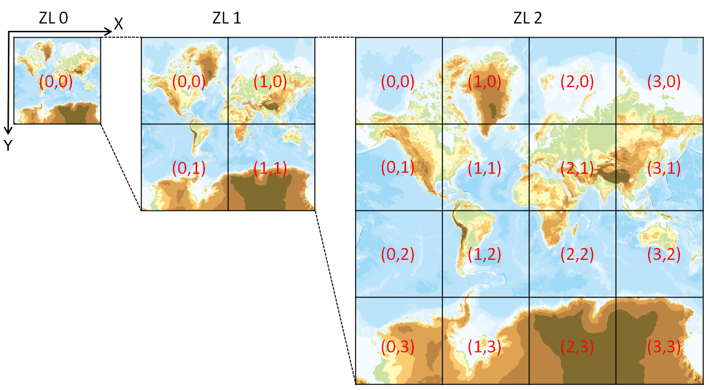
- Map images are separated as tiles.
- Zoom Level 0 = World
- Each zoom level doubles in the dimensions.
- Too many tiles use "Web Mercator" projection.

- Structure of tile is useful for web.
- Enable to scroll map smoothly.
- Enable to zoom up and zoom down map smoothly.
- HTTP GET request.
- Tile become known for Google Maps.
- Tile has existed from the late 1990s.
- Zoom level 0 : 1 file
- Zoom level 1 : 2 x 2 = 4 files
- Zoom level 2 : 4 x 4 = 16 files
- ...
- Zoom level 18 : 2^18 x 2^18 = 262,144 x 262,144 = 68,719,476,736 files
- Many services use REST API(GET Request).
- https://.../Z/X/Y.Format
- Z: Zoom Level
- X: X coordinate
- Y: Y coordinate
- Format:
- Raster image format(png, jpg, webp)
- Vector data format(pbf, mvt)
- https://a.tile.openstreetmap.org/3/2/4.png
- Zoom = 3, X = 2, Y = 4, format = png
- X and Y coordinates start with 0.

- Two tile service specifications are popular.
- Tile Map Service(TMS)
- Web Map Tile Service(WMTS)
- TMS is simpler than WMTS.
- TMS's X Y coordinate is started from bottom left.
- Same as Cartesian coordinate system.
- WMTS's X Y coordinate is started from top left.
- Same as Coordinate system of 2D computer graphics.

- OpenStreetMap use TMS like protocol but Y coordinate is numbered from top.
- OpenStreetMap call "Slippy Map".
- We call xyz tile.
- {z}/{x}/{y}.png
- Also we call zxy tile.
- De facto standard of tiled map.
- Web Mercator projection
- Y coordinate flipped TMS
- Provide REST API
- {z}/{x}/{y}.{format}
- Anyone provide "Specification"
- Too many libraries support XYZ tile.
- Leaflet, OpenLayers, Maplibre GL JS, Google Maps API etc.
- Provides "rendered image"
- The image doesn't have any "data".
- Focus to visualization.

- Provides "Satellite images" or "Aerial photograph"
- Focus to photography.
- The image doesn't have any "data" too.

- Provides "data" as image.
- Focus to data.
- Population, Temperature, Rainfall, Elevation, etc.
- The image has "data" as color.
- Sample raster tiles contain the elevation value obtainable by calculating with RGB values.
- Focus to data.

- Provides "Vector data"
- Each tile contains "Vector data".
- The tile like a data container.
- Each tile contains "Vector data".

- Vector tile doesn't have a style.
- The client renders images with style settings.
- Easy to rotation and bearing.
- Supports 3D rendering.
- The client renders images with style settings.
- Programmable.
- The client can change the style dynamically.
- https://openmaptiles.org/languages/
- Enable to change main language dynamically.

- https://maps.gsi.go.jp/vector/
- GSI provides vector tile.
- Enable to change style dynamically.

- De facto standard of vector tile.
- Vector tile specification by Mapbox Inc.
- Specification
- A tile encoded by Protocol Buffer format.
- Desinged for Web Mercator projection.
- Supports Layers and Features.
https://docs.mapbox.com/data/tilesets/guides/vector-tiles-standards/
- Mapbox provides Mapbox GL JS(Web), Mapbox GL Native(Smartphone and Desktop application).
- Mapbox provides specification of styling. https://docs.mapbox.com/mapbox-gl-js/style-spec/

- Mapbox GL became proprietary software from end of 2020.
- Mapbox GL JS is OpenSource software until v1.5.
- Mapbox GL JS over v2 must require mapbox service’s token.
- MapLibre GL ecosystems are fork of mapbox OpenSource versions.
- https://maplibre.org/
- Highly recommend to use MapLibre GL JS now.
- Leaflet
- https://leafletjs.com/
- Lightweight and easy to use.
- Supports Mapbox Vector Tile with plugin.
- OpenLayers
- https://openlayers.org/
- Difficult to use but powerful.
- Supports Mapbox Vector Tile.
- MapLibre GL JS
- https://maplibre.org/
- Easy to use for Mapbox Vector Tile.
- Supports raster xyz tile too.
- MapLibre GL Native
- https://maplibre.org/
- Easy to use for Mapbox Vector Tile.
- Supports raster xyz tile too.
- Google Maps SDK
- https://developers.google.com/maps/documentation/android-sdk/overview
- Easy to use for raster xyz tile.
- MapLibre GL Native
- https://maplibre.org/
- Easy to use for Mapbox Vector Tile.
- Supports raster xyz tile too.
- Mapkit
- https://developer.apple.com/documentation/mapkit
- Easy to use for raster xyz tile.
- QGIS
- https://qgis.org/
- Supports raster xyz tile.
- Supports Mapbox Vector Tile.
- This presentation requires Linux based OS.
- Also, you can use Raspberry Pi 4.
- Raspberry Pi 4 is cheap and powerful.
- Raspberry Pi 4 is ARM64/aarch64 architecture.
- Raspberry Pi 4 is easy to use for GIS.
- My repository for this presentation supports only ARM64/aarch64 architecture.
- https://gdal.org/
- GDAL/OGR is the most popular GIS library and provides command line tools.
- QGIS based on GDAL/OGR.
- GDAL/OGR supports many GIS data formats.
- GDAL/OGR supports raster xyz tile.
- https://github.com/felt/tippecanoe/
- Build vector tilesets from large (or small) collections of GeoJSON, FlatGeoBuf or CSV features.
- Tippecanoe is the most popular vector tile builder.
- Command line tool for writing Mapbox/MapLibre Vector Style Specification in YAML.
- Organized by The United Nation Vector Tile Toolkit(UNVT).
- Charites convert Style Specification(JSON) to YAML.
- YAML is easy to read and write for human.
- YAML is easy to edit for beginners.
- Charites enable to dynamic serving style.
nanois a simple text editor.- nano is easy to use for both beginners.
vimis a powerful text editor.- vim is difficult to use for beginners.
- vim is easy to use for experts.
- make is a build automation tool.
- make is easy to use for both beginners and experts.
- make is a standard tool of UNIX and Linux.
- This presentation use make for build and deploy.
- nginx is a web server.
- nginx is easy to use for both beginners and experts.
- nginx is a standard tool of UNIX and Linux.
- This presentation use nginx for serving tiles.
- tileserver-gl-light is a vector tile server.
- useful for inspecting vector tile.
- docker is a container platform.
- docker is easy to use for both beginners and experts.
- This presentation use docker for serving tiles or running tileserver-gl-light.
- Digital geographic information
- Provided by International Steering Committee for Global Mapping(ISCGM).
- Composed of 8 Data Sets
- Vector Data (Transportation, Boundaries, Darainage, Population Centre)
- Raster Data (Elevation, Vegetation, Land Cover, Land Use)
- Free for non-commercial use.
- Archives and website were moved into github by GSI.
- Old website was closed
- Some countries provides global map archives at the national site.
- Some links are dead now.
- Vector data provide as Shapefile.
- It provided as Geography Markup Language (GML) format.
- Raster data provide as GeoTiff file.
- It provided as Band interleaved by line (BIL) format.
- https://www.mlit.go.jp/plateau/
- In Japan, Plateau Project release too many Aerial photograph data.
- Plateau released PointCloud, 3D data, and Aerial photograph.
- Aerial photograph is released as GeoTiff data.
- It is good sample to create raster tile.
- https://www.openstreetmap.org/
- OpenStreetMap is the most popular OpenData.
- OpenStreetMap provides planet data as PBF format.
- Today's presentation use OpenStreetMap data as sample data.
- Use small area data for easy to understand.
- Global Map Sri Lanka 1.0
- Global Map Sri Lanka 2.0
- Plateau Higashimurayama City in Tokyo GeoTIFF
- OpenStreetMap data
- Download GeoTIFF file from Global Map archive.
- Enable transparency.
- Convert GeoTIFF to XYZ tile using gdal2tiles.

cd ~/jica_scripts/raster_tile_gm
make fetch # Download GeoTIFF file from Global Map archive.
make transparent # Enable transparency.
make generate_tile # Convert GeoTIFF to XYZ tile using gdal2tiles.
make serve # run nginxfetch:
git clone https://github.com/globalmaps/gmlk10.git
transparent:
gdalbuildvrt -srcnodata "0 0 99" el.vrt gmlk10/el.tif
generate_tile:
gdal_translate -of vrt -expand rgba el.vrt temp.vrt
gdal2tiles.py --xyz -s EPSG:4326 -z 0-11 temp.vrt
serve:
docker run -p 8080:80 -v $(PWD)/temp:/usr/share/nginx/html:ro nginxMakefile is simple to run tasks.
task_name:
commandAccess to http://.local:8080/leaflet.html

- Generate VRT file from GeoTIFF files.
- Convert VRT file to XYZ tile using gdal2tiles.

cd ~/jica_scripts/raster_tile_plateau
make fetch # Download GeoTIFF file from Plateau archive and unarchive
make buildvrt # Generate VRT file from GeoTIFF files.
make generate_tile # Convert VRT file to XYZ tile using gdal2tiles.
make serve # run nginxAccess to http://.local:8080/leaflet.html

- Download Shapefile file from Global Map archive.
- Convert Shapefile to GeoJSON using ogr2ogr.
- Convert GeoJSON to Mapbox Vector Tile using tippecanoe.

make fetch # Download Shapefile file from Global Map archive.
make convert # Convert Shapefile to GeoJSON using ogr2ogr.
make generate # Convert GeoJSON to Mapbox Vector Tile using tippecanoe.
make tileserver-gl # run tileserver-gl-lightAccess to http://.local:8081/

fetch:
	git clone https://github.com/globalmaps/gmlk20.git

convert:
	cd gmlk20; \
	ogr2ogr airp_lka.geojson -s_srs EPSG:4326 -t_srs EPSG:4326 airp_lka.shp; \
	ogr2ogr builtupp_lka.geojson -s_srs EPSG:4326 -t_srs EPSG:4326 builtupp_lka.shp; \
	ogr2ogr coastl_lka.geojson -s_srs EPSG:4326 -t_srs EPSG:4326 coastl_lka.shp; \
	ogr2ogr inwatera_lka.geojson -s_srs EPSG:4326 -t_srs EPSG:4326 inwatera_lka.shp; \
	ogr2ogr polbnda_lka.geojson -s_srs EPSG:4326 -t_srs EPSG:4326 polbnda_lka.shp; \
	ogr2ogr polbndl_lka.geojson -s_srs EPSG:4326 -t_srs EPSG:4326 polbndl_lka.shp; \
	ogr2ogr raill_lka.geojson -s_srs EPSG:4326 -t_srs EPSG:4326 raill_lka.shp; \
	ogr2ogr riverl_lka.geojson -s_srs EPSG:4326 -t_srs EPSG:4326 riverl_lka.shp; \
ogr2ogr roadl_lka.geojson -s_srs EPSG:4326 -t_srs EPSG:4326 roadl_lka.shp- ogr2ogr convert Shapefile to GeoJSON.
- Notes: Those Shapefiles are not included .prj file.
generate:
	tippecanoe -o lka.pmtiles \
	  -L airp:gmlk20/airp_lka.geojson \
	  -L builtupp:gmlk20/builtupp_lka.geojson \
	  -L coastl:gmlk20/coastl_lka.geojson \
	  -L inwatera:gmlk20/inwatera_lka.geojson \
	  -L polbnda:gmlk20/polbnda_lka.geojson \
	  -L polbndl:gmlk20/polbndl_lka.geojson \
	  -L raill:gmlk20/raill_lka.geojson \
	  -L riverl:gmlk20/riverl_lka.geojson \
	  -L roadl:gmlk20/roadl_lka.geojson
	tippecanoe -o lka.mbtiles \
	  -L airp:gmlk20/airp_lka.geojson \
	  -L builtupp:gmlk20/builtupp_lka.geojson \
	  -L coastl:gmlk20/coastl_lka.geojson \
	  -L inwatera:gmlk20/inwatera_lka.geojson \
	  -L polbnda:gmlk20/polbnda_lka.geojson \
	  -L polbndl:gmlk20/polbndl_lka.geojson \
	  -L raill:gmlk20/raill_lka.geojson \
	  -L riverl:gmlk20/riverl_lka.geojson \
	  -L roadl:gmlk20/roadl_lka.geojson
- tippecanoe runs 2 times and generate 2 outputs.
- .mbtiles file
- SQLite database file.
- Contains vector tile.
- .pmtiles file
- "Cloud Native" format.
- You can host .pmtiles as static file.
- .mbtiles file
- MBTiles is container of tile.
- MBTiles is single file database(SQLite).
- TMS schema.

tileserver-gl:
	docker run --rm -it -v $(PWD):/data -p 8080:80 \
	  maptiler/tileserver-gl-light \
-p 80 --file /data/lka.mbtiles- PMTiles is similar to MBTiles.
- "Cloud Native" format.
- You can easy to convert mbtiles to pmtiles using
pmtilescommand.

https://smellman.github.io/pmtiles-example/
- Vector tile doesn't have a style.
- The client renders images with style settings.
- In this presentation, we use
charitesto design tiled map.- Charites convert Style Specification(JSON) to YAML.
- YAML is easy to read and write for human.
- YAML is easy to edit for beginners.
cd ~/jica_scripts/vector_tile
make practice
Open http://.local:8080/ in your browser.
Open other terminal and run following command.
cd ~/jica_scripts/vector_tile
nano style-practice.yml- nano is a simple text editor.
- nano is easy to use for begineer.
- Ctrl + O: Save file
- Ctrl + X: Exit nano

Remove comments in style-practice.yml.
layers:
  - !!inc/file layers/background.yml
#  - !!inc/file layers/polbnda.yml
#  - !!inc/file layers/riverl.yml
#  - !!inc/file layers/inwatera.yml
#  - !!inc/file layers/roadl-primary.yml
#  - !!inc/file layers/roadl-secondary.yml
#  - !!inc/file layers/raill-base.yml
#  - !!inc/file layers/raill-dot.yml
# - !!inc/file layers/airp.yml- Background
- Fill
- Line
- Symbol
- Circle
- Raster
- Hillshade
- Fill Extrusion
- It used for 3D rendering.
https://maplibre.org/maplibre-style-spec/
id: background
type: background
paint:
  background-color: rgb(0,0,0)
id: polbnda
type: fill
source: global_map
source-layer: polbnda
paint:
fill-color: '#f2efe9'- source: global_map means "global_map" source in sources section.
- source-layer: polbnda means "polbnda" layer in global_map source.

id: riverl
type: line
source: global_map
source-layer: riverl
paint:
  line-color: rgb(0,0,255)
  line-width:
    base: 1
    stops:
      - - 6
        - 0.5
      - - 10
        - 2
- Draw line with polyline features.
- Normal line.
- Dash-array line.
- Following example is Normal line + Dash-array line.

roadl-primary.yml and roadl-secondary.yml use filter.
roadl-primary.yml use following filter.
filter:
  - all
  - - '=='
    - rtt
    - '14'
'rtt' is a field name in roadl layer and '14' is primary route.
- Zoom function is useful to change style dynamically.
- Set Zoom 6 to 1 and Zoom 10 to 6, the value will increase between Zoom 6 and 10.
- "base" property will use to control the rate which the function output increases.
- "base = 1" will be increased linearly.
https://maplibre.org/maplibre-style-spec/expressions/
id: airp
type: symbol
source: global_map
source-layer: airp
layout:
  icon-image: airport_11
  text-field: '{nam}'
  text-offset:
    - 0
    - 0.6
- Draw symbol with point features.
- Icon
- Text
- Text with icon
- Allow Point, Polygon and Polyline features.

- icon-image is a property of symbol layer.
- icon-image is a name of icon.
- icon-image is defined in sprite.
- icon-image is a name of icon.
- text-field is a property of symbol layer.
- text-field is a name of field in source data.
- It can use Feature Properties using {field_name}.
- text-field is a name of field in source data.
- text-offset is a property of symbol layer.
- text-offset is a offset of text.
- It can use array of [x, y].
- x and y are offset from center of point.
- text-offset is a offset of text.
layout:
  icon-image: airport_11
  text-field: '{nam}'
  text-offset:
    - 0
- 0.6Stop make practice command and run following command.
make buildMakefile is simple to run tasks.
build:
charites convert style-practice.yml style-practice.jsonmake serveOpen http://.local:8000/ in your browser.

- If you use small number of data only, hosting as static image is easy.
- Use nginx or Apache HTTP Server.
- Use AWS S3 or Google Cloud Storage.
- Github Pages is good for small data and free.
- Be careful to license of tile images.
https://docs.github.com/en/pages/getting-started-with-github-pages/about-github-pages
- If you use large number of data, be careful to hosting.
- File system limitation: max number of files.
- Ext4 on Linux: 4,294,967,295 files(specified at filesystem creation time)
- File copy will take a long time.
- MBTiles is a solution to hosting large number of data.
- MBUtil is useful to create .mbtiles from tile images.
- File system limitation: max number of files.
mb-util temp/ el.mbtiles - Tileserver GL is useful.
- But vector tiles needs SSL access in internet.
- Let's encrypt is useful to get SSL certificate.
- Setup frontend server(Apache/nginx/etc) and connect from server with reverse proxy.

- Nginx is easy to setup reverse proxy.
location / {
    proxy_set_header X-Forwarded-Proto https;
    proxy_set_header X-Forwarded-For $proxy_add_x_forwarded_for;
    proxy_set_header Host $http_host;
    proxy_pass http://localhost:8080;
}- Tileserver GL can deliver raster tile if you host style.
- But rendering is slow.
- If you use this function, you should use cache server.
- But rendering is slow.

- Use varnish cache for raster rendering.
- https://tile.openstreetmap.jp/ use varnish cache.
- 20 processs run.
- 20Core CPU and 64GB RAM.

- PMTiles is useful to hosting vector tile.
- PMTiles is "Cloud Native" format.
- PMTiles is easy to host as static file.
- Nginx / Apache / AWS S3 / Google Cloud Storage etc.
https://github.com/protomaps/PMTiles
add_header 'Access-Control-Allow-Origin' "$http_origin" always;
add_header 'Access-Control-Allow-Credentials' 'true' always;
add_header 'Access-Control-Allow-Methods' 'GET, POST, PUT, DELETE, OPTIONS' always;
add_header 'Access-Control-Allow-Headers' 'Accept,Authorization,Cache-Control,Content-Type,DNT,If-Modified-Since,Keep-Alive,Origin,Range,User-Agent,X-Requested-With' always;

if ($request_method = 'OPTIONS') {
  # Tell client that this pre-flight info is valid for 20 days
  add_header 'Access-Control-Allow-Origin' "$http_origin" always;
  add_header 'Access-Control-Allow-Headers' 'Accept,Authorization,Cache-Control,Content-Type,DNT,If-Modified-Since,Keep-Alive,Origin,Range,User-Agent,X-Requested-With' always;
  add_header 'Access-Control-Max-Age' 1728000;
  add_header 'Content-Type' 'text/plain charset=UTF-8';
  add_header 'Content-Length' 0;
  return 204;
}
see: https://github.com/smellman/pmtiles-example
- IPFS is a peer-to-peer hypermedia protocol.
- IPFS is useful to hosting static files.
- IPFS is useful to hosting PMTiles.
cd ~/jica_scripts/system
make ipfs-init
make ipfs-daemoncd ~/jica_scripts/vector_tile
make ipfsOutput CID is IPFS Content Identifier.
added QmRSsj5FstJt8Rvrvp4GKG4i77yRredn8eHAuYoNkKhWpW lka.pmtiles
Copy CID, then.
nano style-ipfs.ymlPaste CID to sources section.
sources:
  global_map:
    type: vector
    url: >-
      pmtiles://https://smb.optgeo.org/ipfs/<Your CID>
https://smb.optgeo.org/ipfs/ is IPFS gateway server running by Hidenori Fujimura.
cd ~/jica_scripts/vector_tile
make build-ipfs
make serve
Open http://.local:8000/index-ipfs.html in your browser.
- This presentation is licensed under CC BY 4.0.
- All pictures with OpenStreetMap images are licensed under CC BY-SA 2.0.
- © OpenStreetMap contributors