

Ti.GoogleMaps is an open-source project to support the Google Maps iOS-SDK in Appcelerator's Titanium Mobile. The module currently supports the following API's:
- Map View
- Annotations
- Tile overlay
- Polygon overlay
- Polyline overlay
- Circle overlay
- Autocompletion dialog
- Clustering
- Directions
- Heatmap Layers
- All delegates (exposed as events)
- Titanium 10.0.0+
- Minimum Deployment Target iOS 13+

Unpack the module and place it inside the modules/iphone/ folder of your project.
Edit the modules section of your tiapp.xml file to include this module:
<modules>
    <module platform="iphone">ti.googlemaps</module>
</modules>
Initialize the module by setting the Google Maps API key you can get from here.
const maps = require('ti.googlemaps');
maps.setAPIKey('<YOUR_GOOGLE_MAPS_API_KEY>');If you want to use this moduel as a replacement for Ti.Map on iOS, here is how you can have 100 % parity:
- Create a file called
maps.jsinapp/lib/(Alloy) orResources/(Classic) with the following content
if (Ti.Platform.osname === 'iphone' || Ti.Platform.osname === 'ipad') {
  module.exports = TiMap = require('ti.googlemaps');
} else {
  module.exports = TiMap = require('ti.map');
}- In your controllers, import / require the maps instance like before:
// ES6+ (recommended)
import TiMap from 'maps'

// ES5
const TiMap = require('maps');
- (optional) You can even use it in Alloy:
<View module="maps" method="createView" id="mapView" />That's it!
If you want to build the module from the source, you need to check some things beforehand:
- Set the
TITANIUM_SDK_VERSIONinside theios/titanium.xcconfigfile to the Ti.SDK version you want to build with. - Build the project with
appc run -p ios --build-only - Check the releases tab for stable pre-packaged versions of the module
A map view creates the view on which annotations and overlays can be added to. You can see all possible events in the demo app.
In addition, you can specify one of the following constants to the mapType property:
MAP_TYPE_NORMALMAP_TYPE_HYBRIDMAP_TYPE_SATELLITEMAP_TYPE_TERRAINMAP_TYPE_NONE
const mapView = maps.createView({
    mapType: maps.MAP_TYPE_TERRAIN,
    indoorEnabled: true, // shows indoor capabilities (see "Indoor Navigation" section)
    indoorPicker: true, // shows the vertical floor level (see "Indoor Navigation" section)
    compassButton: true, // shows the compass (top/right) when bearing is non-zero
    myLocationEnabled: true, // default: false
    myLocationButton: true, // shows the default My location button
    region: { // Camera center of the map
        latitude: 37.368122,
        longitude: -121.913653,
        zoom: 10, // EITHER: Zoom in points
        latitudeDelta: 0.1, longitudeDelta: 0.1, // OR: LAT/LONG-delta
        bearing: 45, // orientation measured in degrees clockwise from north
        viewingAngle: 30 // measured in degrees
    }
});The GoogleMaps SDK supports configuring the map-view for the iPhone X. Use the paddingAdjustmentBehavior to get
or set the padding-adjustment-behavior and use one of the following constants:
/** 1. Always include the safe area insets in the padding. */
PADDING_ADJUSTMENT_BEHAVIOR_ALWAYS

/**
* 2. When the padding value is smaller than the safe area inset for a particular edge, use the safe
* area value for layout, else use padding.
*/
PADDING_ADJUSTMENT_BEHAVIOR_AUTOMATIC

/**
* 3. Never include the safe area insets in the padding. This was the behavior prior to version 2.5.
*/
PADDING_ADJUSTMENT_BEHAVIOR_NEVER
The module supports all native delegates - exposed as events. These are:
- click - Can be an annotation, overlay or info-window. Use
clicksourceto determine. - mapclick
- locationclick
- longclick
- poiclick
- regionchanged
- regionwillchange
- idle
- dragstart
- dragmove
- dragend
- complete
Note: For annotations, the latitude, longitude and userData is returned, not the whole annotation proxy to keep the performance at it's best. If you want to identify an annotation, either use the generated UUID string in the
userDataor set an own key in theuserDataproperty of your annotation.
mapView.indoorEnabled = false;
mapView.indoorPicker = true;
mapView.compassButton = true;
mapView.myLocationEnabled = false;
mapView.myLocationButton = false;
mapView.trafficEnabled = true; // default is falsemapView.scrollGesture = true;
mapView.zoomGestures = false;
mapView.tiltGestures = true;
mapView.rotateGestures = false;
mapView.allowScrollGesturesDuringRotateOrZoom = false;const currentZoom = mapView.zoomLevel;Note: You can watch the regionchanged event to get real time updates about the zoom level change.
See the event.zoom property for details.
Note: The
mapInsetsproperty is deprecated since Ti.GoogleMaps 4.0.0 in favor this property to achieve better parity with Ti.Map and will be removed in future versions of the module.
mapView.padding = { bottom:200 };// Either a JSON-string
mapView.mapStyle = 'JSON_STYLE_GOES_HERE';
// Or a JSON-file
mapView.mapStyle = 'mapStyle.json'See this link for more infos on map styling.
map.location = {
  latitude: 37.368122,
  longitude: -121.913653,
  latitudeDelta: 0.2,
  longitudeDelta: 0.2,
  animate: true
}
mapView.animateToLocation({
    latitude: 36.368122,
    longitude: -120.913653
});mapView.animateToZoom(5, 2000 /* Optional parameter to specify the duration (in ms) */);mapView.animateToBearing(45);mapView.animateToViewingAngle(30);const imageBlob = mapView.takeSnapshot({
width: 300,
width: 300
});const contains = mapView.containsCoordinate({ latitude: -13.37, longitude: 42.0 });You can perform camera updates to your map view instance by creating an instance of the CameraUpdate API:
const maps = require('ti.googlemaps');
const cameraUpdate = maps.createCameraUpdate();
Before you can use the camera update, you must specify one of this actions:
- zoomIn
cameraUpdate.zoomIn();- zoomOut
cameraUpdate.zoomOut();- zoom
// The second parameter is optional
cameraUpdate.zoom(4, {
    x: 100,
    y: 100
});- **enableMetalRenderer
maps.enableMetalRenderer();- setTarget
cameraUpdate.setTarget({
    latitude: 10.0,
    longitude: 10.0,
    zoom: 4 // optional
});- setCamera
cameraUpdate.setTarget({
    latitude: 10.0,
    longitude: 10.0,
    zoom: 4,
    bearing: 1,
    viewingAngle: 45
});- fitBounds
cameraUpdate.fitBounds({
    // IMPORTANT: Use either `padding` or `insets`, not both together
    padding: 20,
    insets: {top: 10, left: 10, bottom: 10, right: 10},
    bounds: {
        coordinate1: {
            latitude: 10.0,
            longitude: 10.0
        },
        coordinate2: {
            latitude: 12.0,
            longitude: 12.0
        }
    }
});`- scrollBy
cameraUpdate.scrollBy({
    x: 100,
    y: 100
});
After creating the camera update, you can use it in one of the following methods: moveCamera
mapView.moveCamera(cameraUpdate);animateWithCameraUpdate
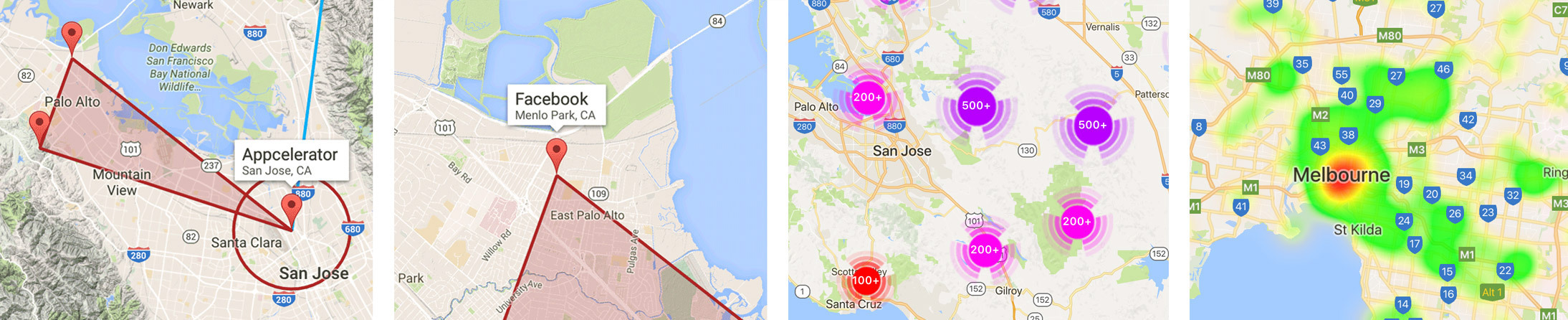
mapView.animateWithCameraUpdate(cameraUpdate);An annotation represents a location specified by at least a title and a subtitle property.
It can be added to a map view:
const annotation = maps.createAnnotation({
    latitude: 37.368122,
    longitude: -121.913653,
    title: 'Appcelerator, Inc',
    subtitle: '1732 N. 1st Street, San Jose',
    pinColor: 'green',
    image: 'pin.png',
    touchEnabled: true, // Default: true
    draggable: true, // Default: false
    flat: true, // Default: false
    opacity: 1,
    zIndex: 1,
    animationStyle: maps.APPEAR_ANIMATION_POP, // One of 'APPEAR_ANIMATION_NONE' (default), 'APPEAR_ANIMATION_POP' or 'APPEAR_ANIMATION_FADE'
    rotation: 30, // measured in degrees clockwise from the default position
    centerOffset: {
        x: 0.5,
        y: 0
    },
    groundOffset: {
        x: 0.5,
        y: 0
    },
    userData: {
        id: 123,
        custom_key: 'custom_value'
    }
});
mapView.addAnnotation(annotation);
You can get a list of all currently added annotations by using mapView.annotations;
You can set an info window of the annotation. Note that you have to specify a width / height for subviews, otherwise the SDK will not set a proper frame for the subview:
const view = Ti.UI.createView({
    backgroundColor: "red",
    width: 200,
    height: 30
});

const label = Ti.UI.createLabel({
    text: key,
    width: 200,
    height: 30,
    color: '#fff',
    textAlign: 'center'
});

view.add(label);

const annotation = maps.createAnnotation({
    latitude: 37.4748624,
    longitude: -122.1490817
    infoWindow: view
});
You can update the location of an Annotation by using:
annotation.updateLocation({
    // Required
    latitude: 36.368122,
    longitude: -125.913653,

    // Optional
    animated: true,
    duration: 1000 // in MS, default: 2000
    opacity: 0.5,
    rotation: 30 // in degrees, clockwise from the default position
});
Since Ti.GoogleMaps 3.5.0, you can also set a custom view. Please note that you need to specify a valid size (width/height) for each view-child of this properly, otherwise the view will not be visible. Example:
const maps = require("ti.googlemaps");
maps.setAPIKey('<api-key>');
const win = Ti.UI.createWindow({
    backgroundColor: '#fff'
});

const mapView = maps.createView({
    region: { // Camera center of the map
        latitude: 37.368122,
        longitude: -121.913653
    }
});

const label = Ti.UI.createLabel({
    text: 'Ti',
    width: Ti.UI.FILL, height: Ti.UI.FILL
});

const view = Ti.UI.createView({
    backgroundColor: 'red',
    width: 30, height: 30
});

view.add(label);

const annotation = maps.createAnnotation({
    latitude: 37.368122,
    longitude: -121.913653,
    title: 'Appcelerator, Inc',
    customView: view
});

mapView.addAnnotation(annotation);

win.add(mapView);
win.open();
You also can add multiple annotations as well as remove annotations again:
mapView.addAnnotations([anno1,anno2,anno3]);
mapView.removeAnnotation(anno4);
Use a module-generated custom pin to improve performance by decrease crossing the bridge
and retaining Titanium proxies natively. Compared to image, you don't pass a blob but only a file
reference and compared to customView, you don't have to pass JS proxies to the module:
const annotation = maps.createAnnotation({
    latitude: 37.368122,
    longitude: -121.913653,
    customIcon: { title: '3+', image: '/images/pin.png', tintColor: 'red', textColor: 'white' }
});
Remove Annotations by passing an array of Annotations:
mapView.removeAnnotations([anno1,anno2,anno3]);Remove all annotations (one shot):
mapView.removeAllAnnotations();You can select and deselect annotations, as well as receive the currently selected annotation:
mapView.selectAnnotation(anno1); // Select
mapView.deselectAnnotation(); // Deselect
const selectedAnnotation = mapView.getSelectedAnnotation(); // Selected annotation, null if no annotation is selectedUse heatmaps-layers in your map-views by providing weighted data and designated gradient-colors.
// Import data
const stations = JSON.parse(Ti.Filesystem.getFile('police_stations.json').read());
const data = [];

// Map data to an array of latitude/longitude/intensity objects
for (const i = 0; i < stations.length; i++) {
  const station = stations[i];

  data.push({
    latitude: station.lat,
    longitude: station.lng,
    intensity: 1.0
  });
}

// Create a new heatmap-layer
const heatmap = maps.createHeatmapLayer({
  weightedData: data,
  radius: 80,
  opacity: 0.8,
  gradient: {
    colors: [ 'green', 'red' ],
    startPoints: [ 0.2, 1.0 ],
    colorMapSize: 256
  }
});

// Add the layer to your map-view
mapView.addHeatmapLayer(heatmap);A autocomplete dialog can be opened modally to search for places in realtime. A number of events helps to work with partial results and final selections.
The whole dialog can be styled (like in the following example) and the default native theming is light.
const dialog = GoogleMaps.createAutocompleteDialog({
    tableCellBackgroundColor: '#333',
    tableCellSeparatorColor: '#444',
    primaryTextColor: '#fff',
    primaryTextHighlightColor: 'blue',
    tintColor: 'blue'
});

// You need a Google Places API key from the Google Developer Console
// This is not the same one like your Google Maps API key
dialog.configure('<YOUR_GOOGLE_PLACES_API_KEY>');

dialog.open();- success
- error
- cancel
Overlays can be added to the map view just like annotations. The module supports the methods addPolygon, addPolyline and addCircle to add overlays and removePolygon, removePolyline and removeCircle to remove them.
A polyline is a shape defined by its points property. It needs at least 2 points to draw a line.
const polyline = maps.createPolyline({
    points: [ { // Can handle both object and array
        latitude: -37.81319,
        longitude: 144.96298
    }, [ -31.95285, 115.85734 ] ], // Important: The longitude is at index 0 and the latitude at index 1
    strokeWidth: 3, // Default: 1
    strokeColor: '#f00'  // Default: Black (#000000),
    title: 'My Polyline',
    zIndex: 10,
    tappable: true
});
mapView.addPolyline(polyline);
You can get a list of all currently added polylines by using mapView.polylines.
You can also set a stamp-styled polyline by setting a dots image:
maps.dotsImage = 'images/my_icon.png';If you want rounded polylines (e.g. for simulating a flight direction), you can use the following method to draw the line:
$.mapView.drawRoundedPolylineBetweenCoordinates({
    coordinates: [ { latitude: 0.0, longitude: 0.0 }, { latitude: 1.0, longitude: 1.0 } ],
    options: {} // Unused so far
});A polygon is a shape defined by its points property. It behaves similiar to a polyline, but is meant to close its area automatically and also supports the fillColor property.
const polygon = maps.createPolygon({
    points: [ { // Can handle both object and array
        latitude: -37.81819,
        longitude: 144.96798
    }, [ -31.95285, 115.85734 ] ],
    strokeWidth: 3,
    fillColor: 'yellow', // Default: Blue (#0000ff)
    strokeColor: 'green',
    title: 'My Polygon',
    holes: [ {
        latitude: -32.95785,
        longitude: 115.86234
    }, [ -32.95785, 115.86234 ] ], // Important: The longitude is at index 0 and the latitude at index 1.
                                   // This has been changed in v6.1.2 of the module to align with the other APIs!
    zIndex: 10
});
mapView.addPolygon(polygon);
You can get a list of all currently added polygons by using mapView.polygons;
A circle is a shape defined by the center property to specify its location as well as the radius in meters.
const circle = maps.createCircle({
    center: [ -32.9689, 151.7721 ], // Can handle object or array. Important: The longitude is at index 0 and the latitude at index 1.
    radius: 500 * 1000, // 500 km, Default: 0
    fillColor: 'blue', // Default: transparent
    strokeWidth: 3,
    strokeColor: 'orange'
    title: 'My Circle',
    zIndex: 10
});
mapView.addCircle(circle);
You can get a list of all currently added circles by using mapView.circles;
You can cluster multiple items by using the Clustering API.
First, create a few cluster items using the ClusterItem:
const items = [];

const clusterItem = maps.createClusterItem({
    // Required
    latitude: 37.368122,
    longitude: -121.913653,

    // Optional - for now only this three properties available
    title: 'My Annotation',
    subtitle: 'Hello World!',
    icon: 'marker.png' // either a String, Ti.Blob or Ti.File
});

// Create some more items here ...

items.push(clusterItem);
Then add the cluster items to a map:
mapView.addClusterItems(items);Finally, call cluster() to generate a new cluster:
mapView.cluster();You are all set! Optionally, you can also set your own cluster ranges and define custom
images for each cluster range in your mapView instance:
const mapView = maps.createView({
    clusterConfiguration: {
        ranges: [ 10, 50, 100, 200, 500 ],
        rangeBackgrounds: [
            'buckets/m1.png',
            'buckets/m2.png',
            'buckets/m3.png',
            'buckets/m4.png',
            'buckets/m5.png'
        ],
        minimumClusterSize: 4,
        maximumClusterZoom: 20,
        animationDuration: 0.5
    },
    region: {
        latitude: 37.368122,
        longitude: -121.913653,
    }
});
To remove cluster-items or clear the whole cluster, use the following methods:
// Remove a single cluster-item
mapView.removeClusterItem(clisterItem);

// Clear the whole cluster
mapView.clearClusterItems();
Use the clusterclick and clusteritemclick events on your map view instance
to receive infos about your current cluster or cluster item.
You can create URL-based tile layers that use the x / y / z (zoom level) pattern to determine the location pattern:
const tile = maps.createTile({
    // Required
	  // z is for zoom level
    url: "http://c.tile.openstreetmap.org/{z}/{x}/{y}.png",

    // Optional
    userAgent: "Titanium rocks!",
    zIndex: 100,
    size: 200,
    opacity: 1,
    fadeIn: true
});

// Clear previous tile cache from this URL
tile.clearTileCache();

// Add tile
mapView.addTile(tile);

// Remove tile
mapView.removeTile(tile);
You can also request a tile image for a specified x/y/zoom position:
const tile = maps.createTile({
    url: "http://c.tile.openstreetmap.org/{z}/{x}/{y}.png",
});

tile.addEventListener('receivetile', event => {
    Ti.API.info(`Received new tile at ${event.tile.x}x${event.tile.y}`);
    Ti.API.info(event);

    // Add tile image to a view or process it somewhere else
    // win.add(Ti.UI.createImageView({ image: event.tile.image }));
});

tile.requestTile({
    x: 200,
    y: 200,
    zoom: 3
});
For more information on Tile Layers: https://developers.google.com/maps/documentation/ios-sdk/tiles
In future releases you will also be able to specify local images, but that is not scheduled so far.
Using Ti.GoogleMaps 3.8.0 and later, you are able to render '.geojson' and '.kml' files inside your map
by using the Renderer API. In can be instantiated by using the following constructor:
const renderer = map.createRenderer({
    file: 'example.geojson'
    mapView: mapView
});
There are two methods render and clear available:
// Renders the geometries
renderer.render();

// Removes the geometries
renderer.clear();Use the reverse geocoder to search a location based on a latitude and longitude:
maps.reverseGeocoder(36.368122, -120.913653, event => {
    alert('Address found!');

    Ti.API.info(event.places);
});There are a number of special API's to deal with indoor-navigtion in GoogleMaps. Inside a View instance,
you can enabled indoor-navigation by setting indoorEnabled to true. To show the the vertical floor levels
in your map-instance, set indoorPicker to true.
To receive the indoor-display, use the indoorDisplay getter,
which has the following events to be notified when the indoor-navigation changes:
-
didChangeActiveBuilding(Raised when the activeBuilding has changed)defaultLevelIndex(Array of GMSIndoorLevel describing the levels which make up the building)isUnderground(Index in the levels array of the default level)levels(Iftrue, the building is entirely underground and supports being hidden)
-
didChangeActiveLevel(Raised when the activeLevel has changed)name(Localized display name for the level, e.g. "Ground floor")shortName(Localized short display name for the level, e.g. "1")
In addition to the above events, you can also communicate with the indoor-display by receiving the activeBuilding
and activeLevel properties. Finally, when receiving the floor-level inside the level property of the
didChangeActiveBuilding event, you can set the activeLevel property as well, to change the currently active
floor-level.
Use the Directions API to calculate advanced directions:
maps.getDirections({
    origin: 'Mountain View, CA',
    destination: 'San Francisco, CA',
    success: event => {
        Ti.API.info(event.routes);
    },
    error: event => {
        Ti.API.error(`Error: ${event.error}`);
    },
    waypoints: [ 'Cupertino, CA', 'via:Sunnyvale, CA' ] // Optional
});
The polyline points will be received encoded:
"polyline": {
    "points": "a}dcF~nchVPLXLHQhAsCDKzAyDPe@fAqC`@aAh@sARc@pCoHJUj@yAj@{AL]`@cAd@iAbAiCnC_HjAsCvAqDL_@l@mB`@sA^kAJ[h@aBPi@DSJWDMHSFS@GXaABIBI\\eAHW?ATy@HSPo@"
}
To decode the polyline points, use the maps.decodePolylinePoints(points) utility method or this utility.
Note that this is not officially supported in the Google Maps iOS SDK. It has been exposed
by using the REST-API in combination with the NSURLSession API and the provided API key.
Check whether or not a given geometry list contains a given location.
const geometryContainsLocation = maps.geometryContainsLocation({
    location: { latitude: 1, longitude: -1 },
    points: [ {
        latitude: 37.368122,
        longitude: -121.234
    }, {
        latitude: 35.368122,
        longitude: -119.234
    } ]
});

console.log(`geometryContainsLocation: ${geometryContainsLocation}`);Get the geometry distance between two given points in meters. The geodesic is included in the calculation.
const location1 = { latitude: 52.687489, longitude: 7.291130 };
const location2 = { latitude: 52.279911, longitude: 8.047179 };

const geometryDistanceBetweenPoints = maps.geometryDistanceBetweenPoints(location1, location2);Returns the coordinate pair for the given screen point
const coordinate = maps.coordinateForPoint({
  x: point.x,
  y: point.y,
});
Google requires you to link the Open Source license somewhere in your app. Use the following API to receive the Google Maps license:
const license = maps.getOpenSourceLicenseInfo();For a full example, check the demos in example/app.js and example/clustering.js.
Hans Knöchel (@hansemannnn / Web)
Apache 2.0
Code contributions are greatly appreciated, please submit a new Pull-Request!