Exit number and Destination Mapping Guide

- An exit number is a number assigned to a road junction, usually an exit from a freeway. It is usually marked on the same sign as the destinations of the exit, as well as a sign in the gore.
-
ref=*is used when the exit has a specific number assigned to it. -
noref=yesis used when the exit doesn't have any official number assigned to it.
-
Open checkautopista2 and zoom to the assigned state. In the search tab (top left corner) click on
search in mapbutton to load all the visible highways in the bounding box. -
Select the assigned highway from the dropdown and click on the
downloadbutton.

- Load the route in JOSM


- Browse along the route and check the ways on both directions at every exit location for the following:
- There is a
motorway_junctionat the start of everymotorway_linkexiting the highway - The
motorway_junctionhas a correct exit numberrefvalue as per the source. - The exit number on both directions are the same
- There is only one exit in a direction for every exit number
Add missing exit numbers
-
Download the data and mapillary layer to locate a signboard around the blue marker in the imagery.
-
Use a combination of Mapillary, Department of Transportation (DoT) documents and Wikipedia to add the
ref=*tag onhighway=motorway_junction(stick to using Mapillary and DoT doc as primary source and move to others in case of unavailability of information) -
If it is confirmed there is no exit number for the
motorway_junctionadd another tagnoref=yesto indicate the exit does not have an official reference number.
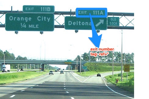
Look out of Highway sign boards on imagery. They may look something like this-

Places to look for-
- near a
motorway_junction - near start of a
motorway_link

-
It is not necessary that exit numbers are sequential. It might find 45 after 41.
-
There are some
motorway_junctionwhich don't have any associated exit number. Addnoref=yeson these nodes.
-
If there are multiple exits on the same signboard then you can tag them as
ref=* ; *instead ofref:left=*andref:right=*until you are confirmed with that. -
In the case of discrepancy between mapillary and DoT document, look out for the recent change in exit numbers on the web. Many states changes/in a process to change the exit numbers.
-
Ignore the
highway=motorway_junctionwhere the traffic flow is towards the motorway
- Destination tags describe the content of signposts or ground writing indicating the names of the locations that a certain exit from the freeway or a highway is heading to.
- The key
destination=*describes where a certain exit leads to. Thus navigation systems can refer to road signs that the driver actually sees.

-
destinationtag refers to the place that the way exiting from the freeway leads to. -
destination:refis the reference of the roads directly ahead. -
destination:ref:tois to specify the reference of a major highway ahead. -
destination:streetrefers to the main street the way exiting from the freeway leads to.
-
Open the destination reference document for your assigned city area. Pick a highway to check and assign it on the spreadsheet to avoid conflict.
-
Open checkautopista2 and zoom to the assigned state. In the search tab (top left corner) click on
search in mapbutton to load all the visible highways in the bounding box. -
Select the assigned highway from the dropdown and click on the
downloadbutton.
- Look out for red outer circle for missing destination. Use
open in JOSMbutton to open the node in JOSM. Orange outer circle representsexit_totag and we don't need to add destination tags in the way. Green outer circle represent that the concern way already has destination tag.
-
Download the data around the
motorway_junctionand mapillary layer to locate a signboard. -
Use combination Mapillary images, DoT documents, and Wikipedia to add destination as
destination=*onmotorway_linkways and the destination highway asdestination:ref=*. Below is a an example On the
 highway=motorway_link(represented by red line) adddestination=Daly Cityanddestination:ref=I 280 South. This can be confirmed with DoT document and wikipedia while searching for exit number 431 -
Add any highway missing in the highway spreadsheet. Mark the highway done if all destination tags are mapped/review
Look out of Highway sign boards on imagery. They may look something like this-
Places to look for-
- near a
motorway_junction - near start of a
motorway_link
- Use
;to separate multiple destination and refs. - Read more on Highway intersection to understand them better.