World population tutorial
This tutorial is designed to introduce a few more advanced Mapnik styling features, mainly Rules and Filters. This XML file is only compatible with Mapnik 2.x and above.
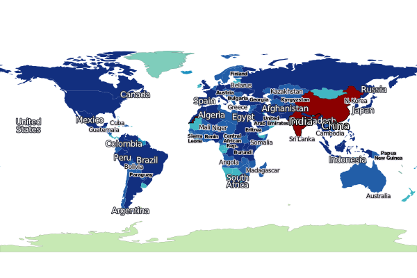
This script should result in a graphic similar to:
- Note: text labeling positions may be different between Mapnik versions.
For this tutorial we'll use the same world borders shapefile from natural earth used for the first two tutorials. Refer to either Tutorial 1 or Tutorial 2 for details.
Save the below code into a file called world_population.py:
#!/usr/bin/env python

import mapnik
mapfile = "world_population.xml"
m = mapnik.Map(1400, 600)
mapnik.load_map(m, mapfile)
bbox = mapnik.Envelope(mapnik.Coord(-180.0, -75.0), mapnik.Coord(180.0, 90.0))
m.zoom_to_box(bbox)
mapnik.render_to_file(m, 'world_population.png', 'png')Save the below XML into a file called world_population.xml in the same directory as the world_population.py python script:
<!DOCTYPE Map>
<!-- Sample Mapnik XML template by Dane Springmeyer -->
<Map srs="+proj=latlong +datum=WGS84" background-color="white" minimum-version="0.7.2">
<Style name="population">
<!-- Built from Seven Class sequential YIGnBu from www.colorbrewer.org -->
<!-- Quantile breaks originally from QGIS layer classification -->
<Rule>
<Filter>[POP_EST] > -1 and [POP_EST] < 15000</Filter>
<PolygonSymbolizer fill="#c7e9b4"/>
<LineSymbolizer stroke="black" stroke-width=".1"/>
</Rule>
<Rule>
<Filter>[POP_EST] >= 15000 and [POP_EST] < 255000</Filter>
<PolygonSymbolizer fill="#7fcdbb"/>
<LineSymbolizer stroke="black" stroke-width=".1"/>
</Rule>
<Rule>
<Filter>[POP_EST] >= 255000 and [POP_EST] < 1300000</Filter>
<PolygonSymbolizer fill="#1d91c0"/>
</Rule>
<Rule>
<Filter>[POP_EST] >= 1300000 and [POP_EST] < 4320000</Filter>
<PolygonSymbolizer fill="#41b6c3"/>
</Rule>
<Rule>
<Filter>[POP_EST] >= 4320000 and [POP_EST] < 9450000</Filter>
<PolygonSymbolizer fill="#225ea8"/>
</Rule>
<Rule>
<Filter>[POP_EST] >= 9450000 and [POP_EST] < 25650000</Filter>
<PolygonSymbolizer fill="#225ea8"/>
</Rule>
<Rule>
<Filter>[POP_EST] >= 25650000 and [POP_EST] < 1134000000</Filter>
<PolygonSymbolizer fill="#122F7F"/>
</Rule>
<Rule>
<ElseFilter/>
<!-- This will catch all other values - in this case just India and China -->
<!-- A dark red polygon fill and black outline is used here to highlight these two countries -->
<PolygonSymbolizer fill="darkred"/>
<LineSymbolizer stroke="black" stroke-width=".7"/>
</Rule>
</Style>
<Style name="countries_label">
<Rule>
<!-- Only label those countries with over 9 Million People -->
<!-- Note: Halo and Fill are reversed to try to make them subtle -->
<Filter>[POP_EST] >= 4320000 and [POP_EST] < 9450000</Filter>
<TextSymbolizer size="7" fill="black" face-name="DejaVu Sans Bold" halo-fill="#DFDBE3" halo-radius="1" wrap-width="20">[NAME]</TextSymbolizer>
</Rule>
<Rule>
<!-- Only label those countries with over 9 Million People -->
<!-- Note: Halo and Fill are reversed to try to make them subtle -->
<Filter>[POP_EST] >= 9450000 and [POP_EST] < 25650000</Filter>
<TextSymbolizer size="9" fill="black" face-name="DejaVu Sans Book" halo-fill="#DFDBE3" halo-radius="1" wrap-width="20">[NAME]</TextSymbolizer>
</Rule>
<Rule>
<!-- Those with over 25 Million get larger labels -->
<Filter>[POP_EST] >= 25650000 and [POP_EST] < 1134000000</Filter>
<TextSymbolizer size="12" fill="white" face-name="DejaVu Sans Book" halo-fill="#2E2F39" halo-radius="1" wrap-width="20">[NAME]</TextSymbolizer>
</Rule>
<Rule>
<!-- Those with over 25 Million get larger labels -->
<!-- Note: allow_overlap is true here to allow India/China to sneak through -->
<Filter>[POP_EST] >= 1134000000</Filter>
<TextSymbolizer size="15" fill="white" face-name="DejaVu Sans Book" halo-fill="black" halo-radius="1" wrap-width="20" allow-overlap="true" avoid-edges="true">[NAME]</TextSymbolizer>
</Rule>
</Style>
<Layer name="countries" srs="+proj=latlong +datum=WGS84" status="on">
<!-- Style order determines layering hierarchy -->
<!-- Labels go on top so they are listed second -->
<StyleName>population</StyleName>
<StyleName>countries_label</StyleName>
<Datasource>
<Parameter name="type">shape</Parameter>
<Parameter name="file">ne_110m_admin_0_countries.shp</Parameter>
</Datasource>
</Layer>
</Map>