The code examples within this repository can be used to automate your RF modelling and/or integrate your application(s) with the powerful CloudRF API.
These examples have been built around some of the most common applications around RF modelling and its presentation.
If you have integrated your own application(s) with the CloudRF API and wish to share with others then pull requests to this repository are welcome. Similarly, if there are common usecases which are not included in these examples please raise a feature request via the GitHub issues submission and we will work towards adding the most popular.
In order to make use of these examples you will require:
- An internet connection which is accessible to the CloudRF API service of https://api.cloudrf.com.
- An account on the CloudRF service with your API key. This can be obtained from https://cloudrf.com/my-account.
Below are the list of available examples which can be used. You are encouraged to read the respective README.md for each which will detail additional information and usage.
- The python directory contains a parent Python 3 script which allows interaction with all of the primary CloudRF API endpoints. This script is quite comprehensive and so for usage you are recommended to consult the README for more information.
- The bash directory contains some Bash scripts which make use of cURL to to CloudRF API.
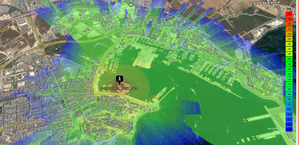
- The slippy-maps directory contains examples of various slippy map libraries which interface with the CloudRF API to present layers of RF coverage and results.
- You can view a live hosted version of the slippy map examples at https://cloud-rf.github.io/CloudRF-API-clients/slippy-maps/index.html
- The templates directory contains a list of example JSON templates which can be used to interface with the CloudRF API. For a more comprehensive list of templates you should consult the CloudRF UI.
- The model-gallery directory contains a HTML demonstration of 3D models.
- You can view a live hosted version of the model gallery at https://cloud-rf.github.io/CloudRF-API-clients/model-gallery/index.html
You are free to use this API in commercial apps with attribution to CloudRF. If you need an exemption get in touch with a business case.
An example of acceptable use would be a online map with a feature to add RF coverage as a layer.
If you are building an application or business which is entirely dependent upon our API, you should contact us first to request approval and establish a service level agreement.
A random example of unacceptable use would be a used car salesman with a business MBA launching a new RF planning tool, without prior communication, which just wraps our API for a markup.
Full terms and conditions are available at https://cloudrf.com/terms-and-conditions
You will be responsible for your account and how it is used.
Below are a list of resources which may aid you with writing your own clients to integrate with the CloudRF API.
- CloudRF Website: https://cloudrf.com/
- API Swagger UI OpenAPI Reference: https://cloudrf.com/documentation/developer/swagger-ui/
- API Postman Reference: https://docs.cloudrf.com/
- 3D User Interface: https://cloudrf.com/ui/
- User Documentation: https://cloudrf.com/documentation
- Video Tutorials: https://youtube.com/cloudrfdotcom