This is a prototype mapping application that demonstrates using real-time routing.
Main View:
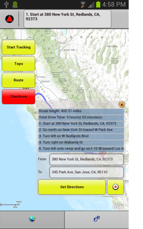
- Real-time Mapping and GPS.
- Displays GPS Location.
- Converts latitude/longitude locations to address
- Calculates and displays textual driving directions.
- Displays current location on map
- Click on textual route info to zoom map
- Draws the route on map
- Apache Flex 4.6 or greater
- Adobe Integrated Runtime (AIR) v3.6 or greater
- Mapping Library - Installation instructions here: ArcGIS API for Flex
- Experience with Flex/ActionScript software development
Click here for more information on installing the mapping library.
Find a bug or want to request a new feature? Please let us know by submitting an Issue on this repo.
Anyone and everyone is welcome to contribute.
Copyright 2013 Esri
Licensed under the Apache License, Version 2.0 (the "License"); you may not use this file except in compliance with the License. You may obtain a copy of the License at
http://www.apache.org/licenses/LICENSE-2.0
Unless required by applicable law or agreed to in writing, software distributed under the License is distributed on an "AS IS" BASIS, WITHOUT WARRANTIES OR CONDITIONS OF ANY KIND, either express or implied. See the License for the specific language governing permissions and limitations under the License.
A copy of the license is available in the repository's license.txt file.
[](Esri Tags: ArcGIS, Mobile, Flex) [](Esri Language: ActionScript)