Dams_and_reservoirs
[[TOC]]
Reservoirs play a big role in the global hydrological cycle. Depending on the size of the reservoir, they significantly change the natural discharge pattern of rivers downstream of the dam. Moreover, reservoirs that are build for irrigation provide additional water supply during dry seasons. This module was developed to improve the simulation of discharge in impacted basins, as well as the supply of irrigation water from the reservoir to nearby irrigated areas.
The information about the location, building year, capacity, area and purposes of the reservoirs are obtained from the GRanD database (Lehner et al, 2011). The coordinates of the reservoirs did not always fall in the right gridcell on the 0.5 degree river network. Therefore, all reservoir larger than 5 km3 were checked and eventually relocated to the corresponding location on the gridded network. Therefore, there are two different input files to use with the STN network and the DDM network (see input)
A reservoir is considered in the model from the (simulation) year that it was built. The reservoir is filled daily with discharge from upstream and precipitation. The start of an operational year for a reservoir is defined as the month when mean monthly inflow shifts from being higher than the mean annual inflow to being lower than the mean annual inflow. At the beginning of the operational year, the actual storage in the reservoir is compared with the maximum storage capacity of the reservoir. To adjust the reservoir release to interannual fluctuations in inflow, a release coefficient is calculated:
where Sfirst,y is the actual reservoir storage at the beginning of the operational year y, C is the maximum storage capacity of the reservoir and is a dimensionless constant that can be
interpreted as the preferred storage level at the start of the new
operational year.
is currently set to 0.85, as in Hanasaki et
al. (2006).
A monthly ‘target release’ rm,y (L d<sup<-1) for month m in operational year y can be interpreted as the optimal release of the reservoir if reservoir capacity would not be limited. The target release depends on the function of the reservoir: for a reservoir that is not built primarily for irrigation (but e.g. hydropower, flood control, navigation), the target release is assumed to be constant during the year
where imean is the mean annual inflow (L d-1) over the last
20 years. The target release for irrigation reservoirs is defined as:
where imean,m is the mean monthly inflow, and dmean and dmean,m are the mean annual and mean monthly irrigation demand to the reservoir respectively (all in L d-1 calculated over the last 20 years). This release algorithm is based on Hanasaki et al. (2006), but has been slightly adjusted. The minimum release of a reservoir is set to 10% of the mean monthly inflow, allowing the outflow to follow the irrigation demand as much as possible, but always leaving 10% of the mean monthly inflow in the river, following the natural intra-annual flow variability.
The actual reservoir release rm,y in month m year y (L d-1) depends on the relative size of the reservoir:
where c equals maximum storage capacity / mean annual inflow
If the reservoir is not built for irrigation purposes, the water is
released directly into the river. Otherwise, part of the released water
can be diverted to irrigated land, except for the water needed to
fulfill the environmental flow requirements (10% of the mean monthly
inflow in this case).
The area that can be supplied from a reservoir is determined by
elevation and . All cells requesting water from a reservoir must lie at
lower altitudes than the cell with the reservoir. Further, they must
either be situated along the main river downstream of the reservoir, or
within reach of this main river at a distance of maximum 5 cells
upstream (approx 250 km at the equator). Consequently, an irrigated cell
can be supplied by two or more reservoirs, in which case the irrigation
demand of that cell is shared between the reservoirs proportional to
their mean volumes. The mean volume of water stored in a reservoir can
change from year to year, and hence shares are updated annually.
Irrigation demands vary from day to day and water that is released for irrigation is made available for a 5 day period. If the water is not used within these 5 days, it is released back into the river, and hence storage possibilities in the conveyance system are simulated. A reservoir’s total water demand is compared with the water that was released from the reservoirs for irrigation. If the total demand can only partly be fulfilled, all cells get the same percentage of the water they requested.
A summary of the operational rules for water supply from reservoirs can be found in figure 1.

Figure 1: Schematic representation of the reservoir and irrigation algorithm
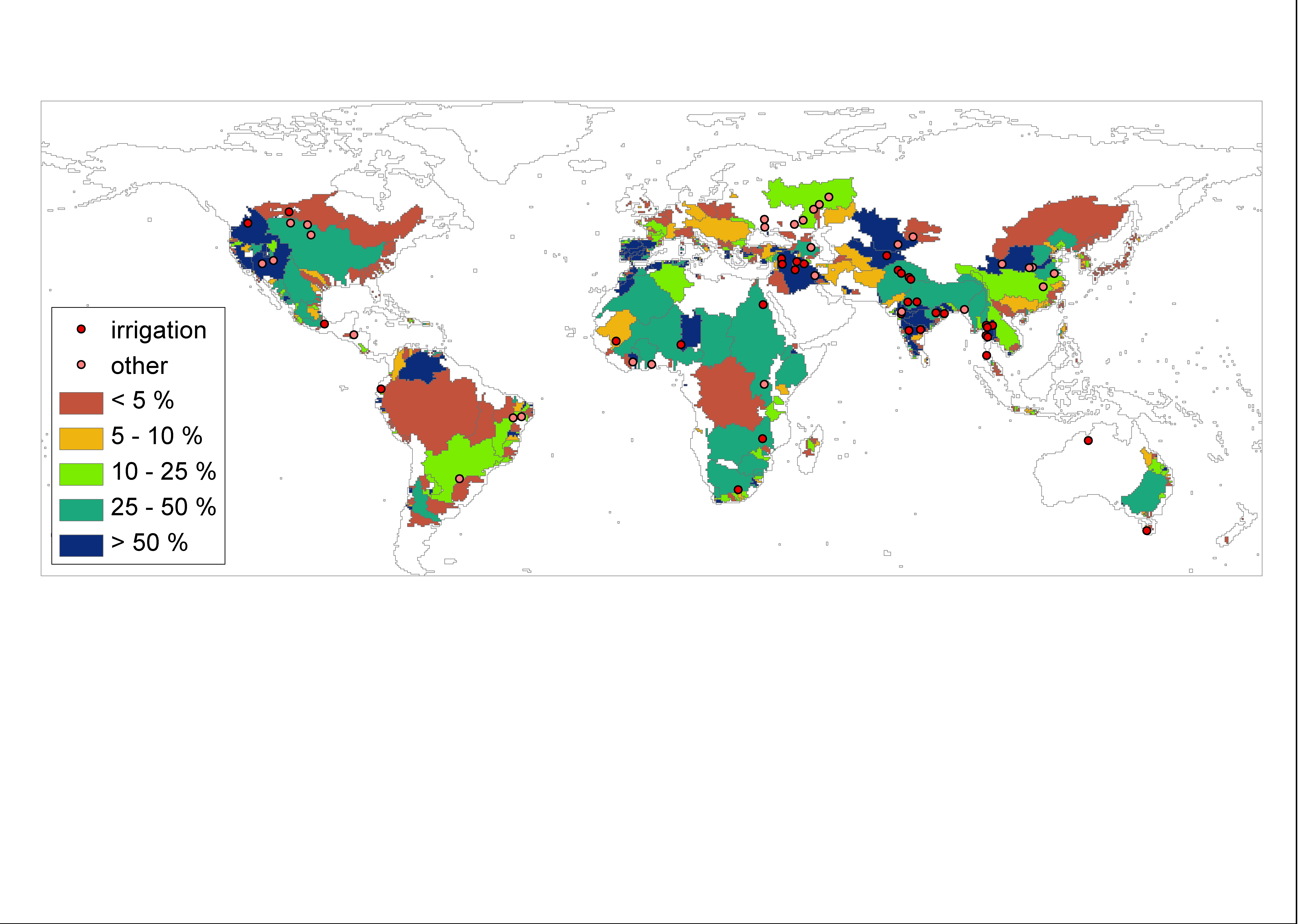
Figure 2:Simulated contributions of reservoirs to total irrigation water supply (average for 1981-2000). Colors represent the additional water withdrawal for irrigation in an ILIM simulation with reservoirs compared to an ILIM simulation without reservoirs. The dots show locations of large reservoirs from which irrigation is supplied, either as a main (red) or secondary (pink) purpose.
Use flags in lpjml.conf:
WITH_RESERVOIRS
RIVER_ROUTING
The reservoirs can only be used with river routing and should be run with limited or potential irrigation setting.
all functions in https://github.com/PIK-LPJmL/LPJmL/blob/master/src/reservoir/
The reservoirs module needs two input files:
1. elevation above sea level to determine which cells can get water
from a reservoir: only cells that are lower can be supplied from a
reservoir. elevation.bin
2. the information about the reservoirs: location, year they were
build, capacity (volume), area, main purpose (irrigation, hydropower, or
other). reservoir_info_grand5.bin relates to the STN river network
and reservoirs_grand_DDM.bin should be used with DDM network.
idea, concept, writing code and paper:
Hester Biemans
additional code writing:
Werner von Bloh, Jens Heinke
input, river routing, irrigation
Biemans, H., I. Haddeland, P. Kabat, F. Ludwig, R.W.A. Hutjes, J. Heinke, W. von Bloh, D. Gerten (2011). Impact of reservoirs on river discharge and irrigation water supply during the 20th century. Water Resources Research, volume 47.
Lehner, B., C. Reidy Liermann, C. Revenga, B. Fekete, C. Vörösmarty, P. Crouzet, P. Döll, M. Endejan, K. Frenken, J. Magome, C. Nilsson, J. Robertson, R. Rödel, N. Sindorf and D. Wisser, 2011. High resolution mapping of global reservoirs and dams and their impact on downstream rivers. Frontiers in Ecology and the Environment.