This work is described in the paper "Real-Time Mesh-based Scene Estimation for Aerial Inspection", by Lucas Teixeira and Margarita Chli, published in the Proceedings of the IEEE/RSJ Conference on Intelligent Robots and Systems (IROS) 2016 [paper].
If you use this Code or Dataset, please cite the following publication:
 @inproceedings{Teixeira:etal:IROS2016,
title	    = {{Real-Time Mesh-based Scene Estimation for Aerial Inspection}},
author	    = {Lucas Teixeira and Margarita Chli},
booktitle	= {Proceedings of the {IEEE/RSJ} Conference on Intelligent Robots and Systems({IROS})},
year	    = {2016}
}
This code is based on the OKVIS VI-SLAM system, but adaptation to other SLAM systems is straightforward. A new topic has been added to publish a point cloud that is sampled over the mesh that is being constructed. As this code is based on OKVIS and the Fade2D library, please acknowledge them together with the paper mentioned above.
This code can be used for research purposes for free under a GPLv3 license. The original OKVIS software has a BSD license, but we use two libraries that are not: Fade2D is a commercial software that can be used for research proposes for free (please check their website http://www.geom.at/), while Scratchapixel.com requests GPLv3 license. We will be working to remove this latter dependence in the future.
This code is tested for Ubuntu 14.04 and ROS Indigo. If you want to run it on a different configuration you will have to change the pointer to the Fade2D library in the main CMakeLists. Note that the Fade2D binaries are included in this code.
sudo apt-get install cmake ros-indigo-pcl-ros libgoogle-glog-dev libatlas-base-dev libeigen3-dev libsuitesparse-dev libboost-dev libboost-filesystem-dev libopencv-devThe best way to try out this code is by creating a new catkin workspace. Using an old workspace, will not allow the proper functioning of okvis_ros as the name of the package was not changed. The installation instructions in the okvis_ros github repository are a useful source of information.
cd ~/catkin_ws/src
git clone --recursive https://github.com/weblucas/okvis_ros_mesh_mapping.git
cd ..
catkin buildUse the provided launch file and one of the bagfiles from our ETHZ_V4RL-CAB Dataset (links below) to run this code. The configuration file config_fpga_v4r4.yaml already contains the calibration data for this dataset, using one camera.
Type the following in a terminal and change the location of the bagfile that you download, accordingly:
roslaunch okvis_ros okvis_node_synchronous_mesh_mapping.launch \
           bagfile:=/home/lucas/data/iros16/ethz_v4rl_ground.bag
In another terminal you should run Rviz with our configuration file:
rviz -d /home/lucas/catkin_ws/src/okvis_ros_mesh_mapping/config/rviz.rviz
The images were captured using a VI-Sensor and calibrated using ETHZ ASL Kalibr. Below are the calibration parameters. Note that T_SC is the transformation from the Camera to the Sensor (IMU). The two sets of values correspond to camera0's intrinsics and camera1's intrinsics, respectively.
cameras:
    - {T_SC:
        [ 0.9999921569165363, 0.003945890103835121, 0.0003406709575200133, -0.030976405894694664,
         -0.003948017768440125, 0.9999711543561547, 0.0064887295612456805, 0.003944069243840622,
         -0.00031505731688472255, -0.0064900236445916415, 0.9999788899431723, -0.016723945219020563,
         0.0, 0.0, 0.0, 1.0],
        image_dimension: [752, 480],
        distortion_coefficients: [0.0038403216668672986, 0.025065957244781098, -0.05227986912373674, 0.03635919730588422],
        distortion_type: equidistant,
        focal_length: [464.2604856754006, 463.0164764480498],
        principal_point: [372.2582270417875, 235.05442086962864]}
    - {T_SC:
        [ 0.9999722760516375, 0.007329193771005421, 0.0013153124248847282, 0.0790982900835488,
          -0.007335059837348439, 0.9999629194070246, 0.004511840884063492, 0.003549628903031918,
          -0.0012821954962168199, -0.00452136369336114, 0.9999889565615523, -0.01713313929463862,
          0.0, 0.0, 0.0, 1.0],
        image_dimension: [752, 480],
        distortion_coefficients: [0.00823121215582322, -0.015270152487108836, 0.03085334360639285, -0.017760720995454376],
        distortion_type: equidistant,
        focal_length: [456.3683366282091, 455.03924786357857],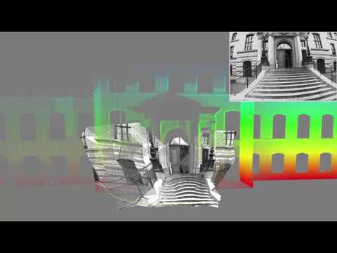
principal_point: [375.1783411236692, 238.22971133267725]}You can reproduce the qualitative results of our paper using this bagfile and this ground-truth laser scan. You can also visualize the point-cloud inside the RViz software together with the laser scan of the facade. You only need to use rosbag play to run the bagfile. You can use the ros node read from the package ethz-asl:point_cloud_io.
For any questions or bug reports, please create an issue if you have questions or bug reports. Alternatively, you can also contact me at lteixeira@mavt.ethz.ch.