Upgrade numpy and install via pip #3145
Merged
Conversation
This file contains bidirectional Unicode text that may be interpreted or compiled differently than what appears below. To review, open the file in an editor that reveals hidden Unicode characters.
Learn more about bidirectional Unicode characters
This reverts commit 4b2f215.
|
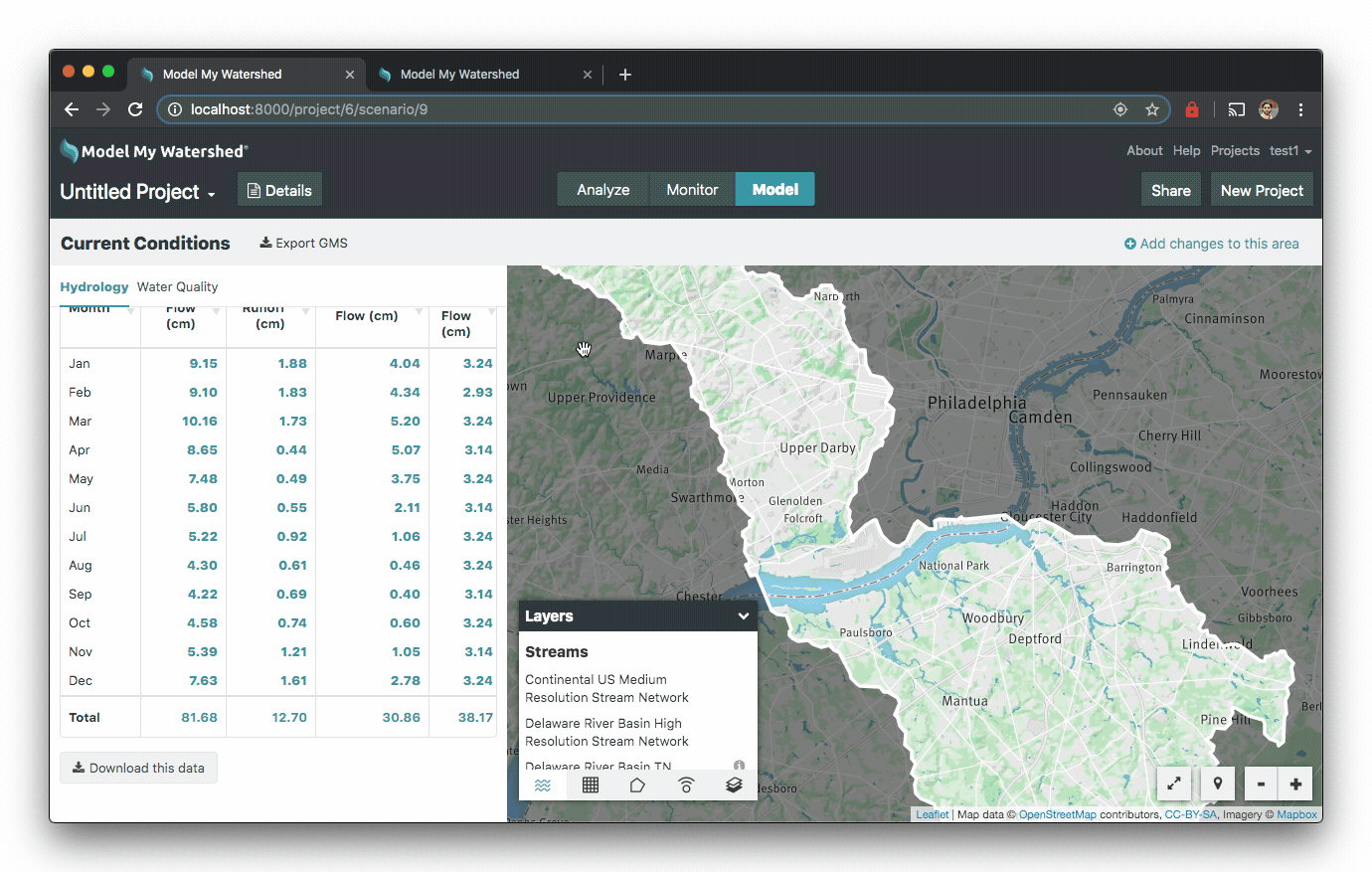
Using the Darby Creek-Mantua Creek, HUC-10 Watershed boundary, I'm seeing different Hydrology, Water Quality, and Summary Load numbers on Local (running on this branch) and Staging:
diff -u staging/mapshed_hydrology.csv local/mapshed_hydrology.csv
--- staging/mapshed_hydrology.csv	2019-08-14 14:37:30.000000000 -0400
+++ local/mapshed_hydrology.csv	2019-08-14 14:37:33.000000000 -0400
@@ -1,14 +1,14 @@
 Month,"Stream Flow (cm)","Surface Runoff (cm)","Subsurface Flow (cm)","Point Src Flow (cm)","ET (cm)","Precip (cm)"
-Jan,8.58,1.88,3.46,3.24,0.59,7.92
-Feb,8.83,1.83,4.06,2.93,0.91,7.25
-Mar,10.03,1.73,5.06,3.24,2.63,8.75
-Apr,8.60,0.44,5.03,3.14,5.09,8.91
-May,7.46,0.49,3.73,3.24,9.07,9.63
-Jun,5.79,0.55,2.10,3.14,12.06,9.26
-Jul,5.22,0.92,1.06,3.24,11.88,10.81
-Aug,4.29,0.61,0.44,3.24,9.00,9.15
-Sep,4.14,0.69,0.31,3.14,5.63,8.69
-Oct,4.47,0.74,0.48,3.24,4.03,6.98
-Nov,5.01,1.21,0.66,3.14,2.25,8.40
-Dec,6.88,1.61,2.02,3.24,1.13,8.71
-Total,79.30,12.70,28.41,38.17,64.27,104.46
+Jan,9.15,1.88,4.04,3.24,0.59,7.92
+Feb,9.10,1.83,4.34,2.93,0.91,7.25
+Mar,10.16,1.73,5.20,3.24,2.63,8.75
+Apr,8.65,0.44,5.07,3.14,5.09,8.91
+May,7.48,0.49,3.75,3.24,9.07,9.63
+Jun,5.80,0.55,2.11,3.14,11.27,9.26
+Jul,5.22,0.92,1.06,3.24,10.70,10.81
+Aug,4.30,0.61,0.46,3.24,8.74,9.15
+Sep,4.22,0.69,0.40,3.14,5.46,8.69
+Oct,4.58,0.74,0.60,3.24,4.03,6.98
+Nov,5.39,1.21,1.05,3.14,2.25,8.40
+Dec,7.63,1.61,2.78,3.24,1.13,8.71
+Total,81.68,12.70,30.86,38.17,61.87,104.46
diff -u staging/mapshed_water_quality_loads.csv local/mapshed_water_quality_loads.csv
--- staging/mapshed_water_quality_loads.csv	2019-08-14 14:36:36.000000000 -0400
+++ local/mapshed_water_quality_loads.csv	2019-08-14 14:36:46.000000000 -0400
@@ -10,7 +10,7 @@
 "High-Density Mixed","242,440.8","5,323.9",546.6
 "Low-Density Open Space","205,543.5","5,469.9",581.6
 "Farm Animals",0.0,"6,833.7","1,663.0"
-"Stream Bank Erosion","253,144,182.0","136,021.0","46,096.0"
-"Subsurface Flow",0.0,"312,448.0","4,044.5"
+"Stream Bank Erosion","257,710,534.0","138,474.0","46,927.0"
+"Subsurface Flow",0.0,"338,819.4","4,385.9"
 "Point Sources",0.0,"1,752,465.0","77,164.0"
 "Septic Systems",0.0,"26,609.9",0.0
diff -u staging/mapshed_water_quality_summary_loads.csv local/mapshed_water_quality_summary_loads.csv
--- staging/mapshed_water_quality_summary_loads.csv	2019-08-14 14:36:32.000000000 -0400
+++ local/mapshed_water_quality_summary_loads.csv	2019-08-14 14:36:44.000000000 -0400
@@ -1,5 +1,5 @@
 Sources,Sediment,"Total Nitrogen","Total Phosphorus"
-"Total Loads (kg)","256,032,527.2","2,267,038.5","133,262.6"
-"Loading Rates (kg/ha)","6,137.73",54.35,3.19
-"Mean Annual Concentration (mg/L)",774.03,6.85,0.40
-"Mean Low-Flow Concentration (mg/L)",954.55,9.62,0.61
+"Total Loads (kg)","260,598,879.2","2,295,862.9","134,435.0"
+"Loading Rates (kg/ha)","6,247.20",55.04,3.22
+"Mean Annual Concentration (mg/L)",764.69,6.74,0.39
+"Mean Low-Flow Concentration (mg/L)",944.49,9.49,0.60
diff -u staging/project.gms local/project.gms
--- staging/project.gms	2019-08-14 14:56:31.000000000 -0400
+++ local/project.gms	2019-08-14 14:55:57.000000000 -0400
@@ -1,5 +1,5 @@
 10,6,0
-1.4.0,0.03228491379310344,0,10,0,0,0.06723457566537072,12.065378195901392,381204,3188.046345500479,378015.9536544995,619.7222697814921,0,2.9980752361369207,0.0045102962476675475,30,1961,1990,0.003255958295489718,59397.940628333665,0,0,0,0.18325275269809418
+1.4.0,0.03228491379310344,0,10,0,0,0.06723457566537072,9.418960164181,381204,3188.046345500479,378015.9536544995,619.7222697814921,0,2.9980752361369207,0.0045102962476675475,30,1961,1990,0.003255958295489718,59397.940628333665,0,0,0,0.18325275269809418
 0
 0
 0
Relevant files are in here: numpy-upgrade.zip. I'll try and take a look to see if I can figure out the source of this discrepancy. |
|
As can be seen in the above diff, there is for some reason a difference in their Avg AWC value (Line 2 Comma 8 in the GMS file), which is causing the difference in numbers. That value is sourced from GeoTrellis rasters, and does not go through NumPy. It may be cached from an earlier run, either on my local or on staging. I tried other shapes and the numbers match up there. |
rajadain
approved these changes
Aug 15, 2019
|
Thanks! |
Sign up for free
to join this conversation on GitHub.
Already have an account?
Sign in to comment
Add this suggestion to a batch that can be applied as a single commit.
This suggestion is invalid because no changes were made to the code.
Suggestions cannot be applied while the pull request is closed.
Suggestions cannot be applied while viewing a subset of changes.
Only one suggestion per line can be applied in a batch.
Add this suggestion to a batch that can be applied as a single commit.
Applying suggestions on deleted lines is not supported.
You must change the existing code in this line in order to create a valid suggestion.
Outdated suggestions cannot be applied.
This suggestion has been applied or marked resolved.
Suggestions cannot be applied from pending reviews.
Suggestions cannot be applied on multi-line comments.
Suggestions cannot be applied while the pull request is queued to merge.
Suggestion cannot be applied right now. Please check back later.
Overview
Undos work done in #3090 to get around an issue with numpy, and installs an updated version of numpy that is compatible with ulmo and other dependencies.
Connects #3093
Testing Instructions
Checklist
./scripts/testem.sh