Add some of the new political entities #343
Conversation
|
The maps are perfect. Thanks for adjusting the zoom levels! I also agree with your decisions regarding country names and info. I only see one minor issue in the French country info of Bougainville: I would remove the article
Off the top of my head, it's the same situation as for Zanzibar, Guernsey, and the now-defunct Saint Helena and Easter Island. Perhaps we could add something in the guidelines about choosing the short name when it's the same as the territory's main island? Thank you so much for this! 🎉 |
e14c5e2
to
8e48509
Compare
|
Thanks for the feedback!
There are, however, also cases like Yaren where "District" is removed from the name, (it's actually what I relied on as "precedent", as I forgot about Guernsey etc.). It is covered by a more "liberal" reading of the general rule about parenthetical portions, but obviously not by the more specific rule about islands/territories, so I'm not sure whether explicitly adding the latter would be useful. Perhaps we could mention one of the territory/island cases as an example of the general rule, though? I'll upload the new maps to Wikimedia asap, and update |
8e48509
to
2615902
Compare
|
Awesome stuff, thanks! 🚀 |
|
Oops, I had forgotten to squash when I had finished! |
|
Oh no worries, it's actually nice to see each new entity as a commit. 💯 |
I've chosen one commit (or more) per country for ease of inspection. I'll squash before merging.
The maps are "under the fold" at the bottom!
Wallis and Futuna
Used SNL for Norwegian name of territory. (The brochure didn't have a corresponding entry.)
Akrotiri and Dhekelia
For reproducibility script for adjusting colours
Neither the brochure nor SNL had a dedicated entry, so I used Norwegian Wikipedia.
Country info duplicated from Falkland Islands, other than the Norwegian which wasn't applicable, and hence just used the generic:
("British overseas territory".)
Svalbard
Country info (provisional)
English taken from the infobox:
German based on German equivalent of "Unincorporated area" (dropping "internal") https://de.wikipedia.org/wiki/Gemeindefreies_Gebiet#Norwegen
(The German article didn't have an appropriate description in the infobox nor (AFAICT) in the main text.)
or perhaps alternatively:
(but is it really "overseas" (it is technically across the Norwegian sea)?)
Spanish adapted from the infobox:
(Obviously this is different from the English version.)
Possibly could just use the generic:
French adapted from status in the infobox:
(Obviously again different from English.)
Possibly could instead just use the generic:
Norwegian adapted from Falkland islands:
(It's also how the Norwegian Wikipedia article describes them.)
Alternative names
I haven't mentioned Spit(s|z)bergen as an alternative name (for English, French and Spanish) since the relevant articles say that it was called that until 1925, not that it's a current alternative name for the territory.
Similarly, I haven't mentioned Svalbard as an alternative (for German) since the German article says that it's not actually used (they stick with the old pre-1925 name).
However, I'm not quite sure whether this is the right decision.
Alternative map
I zoomed out slightly to give more context.
Script for zooming out for reproducibility
(I obviously didn't obtain the paramters by playing around with sed, but it provides a compact way of representing the changes. (A diff/patch would be longer.))
Hawaii
Country info
Chosen to be "State of the United States." and the equivalents (which were readily found — though obviously corrections still welcome!)
Alternative map
I zoomed out slightly to give more context.
Script for zooming out for reproducibility
(I obviously didn't obtain the paramters by playing around with sed, but it provides a compact way of representing the changes. (A diff/patch would be longer.))
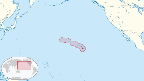
Bougainville
I used the shorter "Bougainville" instead of the longer "Autonomous Region of Bougainville" (Bougainville also, among other things, refers to the island of Bougainville which is the main component of the region). (I'm interpreting "parenthetical" in our Contributing guidelines in the slightly wider meaning, i.e. not purely "surrounded by parenthesis".)
I'm not quite happy about the map, since it'd benefit from a zoom-box. However since I think that it's borderline acceptable and adding a zoom-box would take even more playing around with maps, I'm leaving it as-is, if you agree that it's (just-about) acceptable.
Edit, since I forgot:
New maps
ug-map-wallis_and_futuna.png
ug-map-akrotiri_and_dhekelia.png
ug-map-svalbard.png
original (as was on Wikipedia):
zoomed out:
ug-map-hawaii.png
original:
zoomed out:
ug-map-alaska.png
ug-map-bougainville.png