This plugin is a thin wrapper for Google Maps Android API and Google Maps SDK for iOS.
Both PhoneGap and Apache Cordova are supported.
Stable version(npm)
$> cordova plugin add cordova-plugin-googlemaps \
    --variable API_KEY_FOR_ANDROID="..." \
    --variable API_KEY_FOR_IOS="..."
Develop version (current multiple_maps branch)
$> cordova plugin add https://github.com/mapsplugin/cordova-plugin-googlemaps#multiple_maps \
    --variable API_KEY_FOR_ANDROID="..." \
    --variable API_KEY_FOR_IOS="..."
If you re-install the plugin, please always remove the plugin first, then remove the SDK
$> cordova plugin rm cordova-plugin-googlemaps

$> cordova plugin rm com.googlemaps.ios

$> cordova plugin add cordova-plugin-googlemaps \
    --variable API_KEY_FOR_ANDROID="..." \
    --variable API_KEY_FOR_IOS="..." \
--no-fetch$> npm cache clean
$> cordova platform rm android ios
// Add the SDK plugin at first with --nofetch option
$> cordova plugin add https://github.com/mapsplugin/cordova-plugin-googlemaps-sdk --nofetch
$> cordova plugin add cordova-plugin-googlemaps --nofetch
$> cordova platform add android ios
You can also configure the following variables to customize the iOS location plist entries
LOCATION_WHEN_IN_USE_DESCRIPTIONforNSLocationWhenInUseUsageDescription(defaults to "Show your location on the map")LOCATION_ALWAYS_USAGE_DESCRIPTIONforNSLocationAlwaysUsageDescription(defaults t "Trace your location on the map")
Example using the Cordova CLI
$> cordova plugin rm cordova-plugin-googlemaps

$> cordova plugin rm com.googlemaps.ios

$> cordova plugin add cordova-plugin-googlemaps \
    --variable API_KEY_FOR_ANDROID="..." \
    --variable API_KEY_FOR_IOS="..." \
    --variable LOCATION_WHEN_IN_USE_DESCRIPTION="My custom when in use message" \
    --variable LOCATION_ALWAYS_USAGE_DESCRIPTION="My custom always usage message"
Example using config.xml
<plugin name="cordova-plugin-googlemaps" spec="2.0.0">
    <variable name="API_KEY_FOR_ANDROID" value="YOUR_ANDROID_API_KEY_IS_HERE" />
    <variable name="API_KEY_FOR_IOS" value="YOUR_IOS_API_KEY_IS_HERE" />
    <variable name="LOCATION_WHEN_IN_USE_DESCRIPTION" value="My custom when in use message" />
    <variable name="LOCATION_ALWAYS_USAGE_DESCRIPTION" value="My custom always usage message" />
</plugin>-
plugin.google.maps.geometry.polynamespace is added. -
HtmlInfoWindowfollows the marker smoothly. -
The code of
external serviceremoved. Please use the Launch Navigator Cordova/Phonegap Plugin instead. -
The calculation of DOM element hierarchy was fixed.
-
@ionic-native/google-maps@4.3.3 was released.
-
v2.1.1 has small bug fixes.

<script type="text/javascript">
var map;
document.addEventListener("deviceready", function() {
  var div = document.getElementById("map_canvas");

  // Initialize the map view
  map = plugin.google.maps.Map.getMap(div);

  // Wait until the map is ready status.
  map.addEventListener(plugin.google.maps.event.MAP_READY, onMapReady);
}, false);

function onMapReady() {
  var button = document.getElementById("button");
  button.addEventListener("click", onButtonClick);
}

function onButtonClick() {

  // Move to the position with animation
  map.animateCamera({
    target: {lat: 37.422359, lng: -122.084344},
    zoom: 17,
    tilt: 60,
    bearing: 140,
    duration: 5000
  }, function() {

    // Add a maker
    map.addMarker({
      position: {lat: 37.422359, lng: -122.084344},
      title: "Welecome to \n" +
             "Cordova GoogleMaps plugin for iOS and Android",
      snippet: "This plugin is awesome!",
      animation: plugin.google.maps.Animation.BOUNCE
    }, function(marker) {

      // Show the info window
      marker.showInfoWindow();

      // Catch the click event
      marker.on(plugin.google.maps.event.INFO_CLICK, function() {

        // To do something...
        alert("Hello world!");

      });
    });
  });
}
</script>Quick examples
 Map |
var options = {
  camera: {
    target: {lat: ..., lng: ...},
    zoom: 19
  }
};
var map = plugin.google.maps.Map.getMap(mapDiv, options) |
 Marker |
map.addMarker({
  position: {lat: ..., lng: ...},
  title: "Hello Cordova Google Maps for iOS and Android",
  snippet: "This plugin is awesome!"
}, function(marker) { ... }) |
 MarkerCluster |
map.addMarkerCluster({
  //maxZoomLevel: 5,
  boundsDraw: true,
  markers: dummyData(),
  icons: [
      {min: 2, max: 100, url: "./img/blue.png", anchor: {x: 16, y: 16}},
      {min: 100, max: 1000, url: "./img/yellow.png", anchor: {x: 16, y: 16}},
      {min: 1000, max: 2000, url: "./img/purple.png", anchor: {x: 24, y: 24}},
      {min: 2000, url: "./img/red.png",anchor: {x: 32,y: 32}}
  ]
}, function(markerCluster) { ... }); |
 HtmlInfoWindow |
var html = "<img src='./House-icon.png' width='64' height='64' >" +
           "<br>" +
           "This is an example";
htmlInfoWindow.setContent(html);
htmlInfoWindow.open(marker);
|
 Circle |
map.addCircle({
  'center': {lat: ..., lng: ...},
  'radius': 300,
  'strokeColor' : '#AA00FF',
  'strokeWidth': 5,
  'fillColor' : '#880000'
}, function(circle) { ... }); |
 Polyline |
map.addPolyline({
  points: AIR_PORTS,
  'color' : '#AA00FF',
  'width': 10,
  'geodesic': true
}, function(polyline) { ... }); |
 Polygon |
map.addPolygon({
  'points': GORYOKAKU_POINTS,
  'strokeColor' : '#AA00FF',
  'strokeWidth': 5,
  'fillColor' : '#880000'
}, function(polygon) { ... }); |
 GroundOverlay |
map.addPolygon({
  'points': GORYOKAKU_POINTS,
  'strokeColor' : '#AA00FF',
  'strokeWidth': 5,
  'fillColor' : '#880000'
}, function(polygon) { ... }); |
 TileOverlay |
map.addTileOverlay({
  debug: true,
  opacity: 0.75,
  getTile: function(x, y, zoom) {
    return "../images/map-for-free/" + zoom + "_" + x + "-" + y + ".gif"
  }
}, function(tileOverlay) { ... }); |
 Geocoder |
plugin.google.maps.Geocoder.geocode({
  // US Capital cities
  "address": [
    "Montgomery, AL, USA", ... "Cheyenne, Wyoming, USA"
  ]
}, function(mvcArray) { ... }); |
 poly utility |
var GORYOKAKU_POINTS = [
  {lat: 41.79883, lng: 140.75675},
  ...
  {lat: 41.79883, lng: 140.75673}
]
var contain = plugin.google.maps.geometry.poly.containsLocation(
                    position, GORYOKAKU_POINTS);
marker.setIcon(contain ? "blue" : "red");
|
 encode utility |
var GORYOKAKU_POINTS = [
  {lat: 41.79883, lng: 140.75675},
  ...
  {lat: 41.79883, lng: 140.75673}
]
var encodedPath = plugin.google.maps.geometry.
                       encoding.encodePath(GORYOKAKU_POINTS);
|
 spherical utility |
var heading = plugin.google.maps.geometry.spherical.computeHeading(
                        markerA.getPosition(), markerB.getPosition());
label.innerText = "heading : " + heading.toFixed(0) + "°";
|
This plugin displays the map view of native(Java and Objective-C) features, which is faster than Google Maps JavaScript API v3.
And the native map view works even if the device is offline.
This plugin provides the features of the native map view to JS developers.
You can write your code similar like the Google Maps JavaScript API v3.
Features compare table
| Google Maps JavaScript API v3 | Cordova-Plugin-GoogleMaps | |
|---|---|---|
| Rendering system | JavaScript + HTML | JavaScript + Native APIs |
| Offline map | Not possible | Possible (only you displayed area) |
| 3D View | Not possible | Possible |
| Platform | All browsers | Android and iOS app only |
| Tile image | Bitmap | Vector |
Class compare table
| Google Maps JavaScript API v3 | Cordova-Plugin-GoogleMaps |
|---|---|
| google.maps.Map | Map |
| google.maps.Marker | Marker |
| google.maps.InfoWindow | Default InfoWindow, and HtmlInfoWindow |
| google.maps.Circle | Circle |
| google.maps.Rectangle | Polygon |
| google.maps.Polyline | Polyline |
| google.maps.Polygon | Polygon |
| google.maps.GroundOverlay | GroundOverlay |
| google.maps.ImageMapType | TileOverlay |
| google.maps.MVCObject | BaseClass |
| google.maps.MVCArray | BaseArrayClass |
| google.maps.Geocoder | plugin.google.maps.geocoder |
| google.maps.geometry.spherical | plugin.google.maps.geometry.spherical |
| google.maps.geometry.encoding | plugin.google.maps.geometry.encoding |
| google.maps.geometry.poly | plugin.google.maps.geometry.poly |
| (not available) | MarkerCluster |
| google.maps.KmlLayer | KMLLayer (v1.4.5 is available) |
| google.maps.StreetView | (not available) |
| google.maps.Data | (not available) |
| google.maps.DirectionsService | (not available) |
| google.maps.DistanceMatrixService | (not available) |
| google.maps.FusionTablesLayer | (not available) |
| google.maps.TransitLayer | (not available) |
| google.maps.places.* | (not available) |
| google.maps.visualization.* | (not available) |
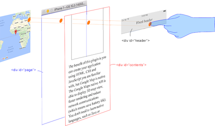
This plugin generates native map views, and put them under the browser.
The map views are not an HTML element. It means they are not kind of <div> or something.
But you can specify the size, position of the map view using <div>.
This plugin changes the background as transparent of your app.
Then the plugin detects your finger tap position which is for: native map or html element.

The benefit of this plugin is able to detect which HTML elements are over the map or not automatically.
In the below image, you tap on the header div, which is over the map view. This plugin detects your tap is for the header div or the map view, then pass the mouse event.
It means you can use the native Google Maps views similar like HTML element.
-
Google+ : @wf9a5m75 https://plus.google.com/communities/117427728522929652853
-
Gitter : @Hirbod https://gitter.im/nightstomp/cordova-plugin-googlemaps
We appreciate if you donate some amount to help this project from this button.
The donated amount is used for buying testing machine (such as iPhone, Android) or new software.
Thank you for supporting us by bitcoin.
3LyVAfANZwcitEEnFbsHup3mDJfuqp8QFb