Add rendering natural=spring on area #1482
Comments
I would consider such area as wetland, and I would tag it this way - what would result in expected rendering (though it would require two areas, one for natural=spring, one for natural=wetland). |
|
Is this issue to be closed, as you have suggested, or maybe it's something to be considered in #325? |
|
@kocio-pl this should be closed for the reasons above. |
|
Why is this being closed so suddenly? |
|
Sorry, for me it's a problem about old discussions without reaching conclusions. There may be many valid arguments, but in the end it's decision what to do. Moreover it's hard for me to imagine such area - could you give an example? |
|
As I know, we map water areas as natural=water (or natural=wetland). 'Natural=spring' tag should be added to the first node of a river/ stream way, not water area. |
|
Can you give examples and say why you consider the tagging wrong? Springs can be quite large, have a look at https://en.wikipedia.org/wiki/Big_Spring_%28Missouri%29 for one that can spit out up to 57 cubical meters per second! Why does it not deserve an area? Whether natural=spring on an area should imply being a body of water, or needs an extra outline around, is subject to further discussion. |
|
This example sounds convincing for me. Since there's also a discussion, I reopen this ticket. If we should render such area, how should we do it? Just like a node spring or maybe different? |
|
Actually, it can be tagged in two ways - the one which I described above, and also as natural=spring area (anyway first node of stream/ river should be connected with spring node/ area) |
|
For the thousandth time: This is not the place to discuss tagging. If a spring can be mapped as a polygon is not the issue here. The issue here is if polygons tagged |
Right, but as tagging and rendering are related, it is necessary to point out which things are well defined, and which need further discussion. |
|
Example of spring tagged on area, after recent refurbishment: Due to #3253, the icon would be invisible if the spring area were mapped as a natural=water body. |
|
#3253 was fixed by #3738, so spring icons now render above water areas without problems. I agree with the comments above #1482 (comment) - a spring can be mapped as an area of water or a wetland. Closed. |
|
I don't agree with the solution of tagging them as water, because they lose their property of being a spring that way. People have now tried to solve this by using water=spring, but I thought we were told not to map for the renderer which the solution of tagging them as water bodies absolutely is doing. |
I don't think anyone has suggested this here. The problem that mappers need to apply several primary tags with the same key to the same geometry is a common one and not unique to springs - the common technique is to create two features representing the two different concepts (the spring as well as the water covered area/the area of water saturated ground a.k.a. wetland). This also allows applying secondary tags in a semantically non-ambiguous way. |
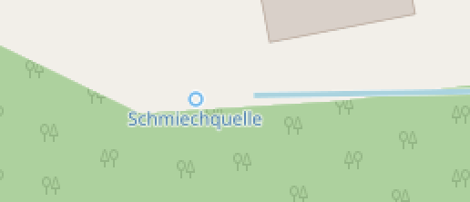
Currently springs are only rendered with an icon+name, even when they are mapped as an area.
Small example: http://www.openstreetmap.org/way/206317365
however springs of larger rivers often seep through the sand on a larger area, so this tagging is valid.
It would probably be simple to fill the area with water colour, however it might need to be considered when changing the icon in #1384.
Alternatively, the spring area could be filled with a pattern of spring icons, similar to wetland.
Stats: Node: 58K, area+relation: 690
The text was updated successfully, but these errors were encountered: