-
Notifications
You must be signed in to change notification settings - Fork 37
/
03-USA-NPN.Rmd
1187 lines (794 loc) · 63.4 KB
/
03-USA-NPN.Rmd
1
2
3
4
5
6
7
8
9
10
11
12
13
14
15
16
17
18
19
20
21
22
23
24
25
26
27
28
29
30
31
32
33
34
35
36
37
38
39
40
41
42
43
44
45
46
47
48
49
50
51
52
53
54
55
56
57
58
59
60
61
62
63
64
65
66
67
68
69
70
71
72
73
74
75
76
77
78
79
80
81
82
83
84
85
86
87
88
89
90
91
92
93
94
95
96
97
98
99
100
101
102
103
104
105
106
107
108
109
110
111
112
113
114
115
116
117
118
119
120
121
122
123
124
125
126
127
128
129
130
131
132
133
134
135
136
137
138
139
140
141
142
143
144
145
146
147
148
149
150
151
152
153
154
155
156
157
158
159
160
161
162
163
164
165
166
167
168
169
170
171
172
173
174
175
176
177
178
179
180
181
182
183
184
185
186
187
188
189
190
191
192
193
194
195
196
197
198
199
200
201
202
203
204
205
206
207
208
209
210
211
212
213
214
215
216
217
218
219
220
221
222
223
224
225
226
227
228
229
230
231
232
233
234
235
236
237
238
239
240
241
242
243
244
245
246
247
248
249
250
251
252
253
254
255
256
257
258
259
260
261
262
263
264
265
266
267
268
269
270
271
272
273
274
275
276
277
278
279
280
281
282
283
284
285
286
287
288
289
290
291
292
293
294
295
296
297
298
299
300
301
302
303
304
305
306
307
308
309
310
311
312
313
314
315
316
317
318
319
320
321
322
323
324
325
326
327
328
329
330
331
332
333
334
335
336
337
338
339
340
341
342
343
344
345
346
347
348
349
350
351
352
353
354
355
356
357
358
359
360
361
362
363
364
365
366
367
368
369
370
371
372
373
374
375
376
377
378
379
380
381
382
383
384
385
386
387
388
389
390
391
392
393
394
395
396
397
398
399
400
401
402
403
404
405
406
407
408
409
410
411
412
413
414
415
416
417
418
419
420
421
422
423
424
425
426
427
428
429
430
431
432
433
434
435
436
437
438
439
440
441
442
443
444
445
446
447
448
449
450
451
452
453
454
455
456
457
458
459
460
461
462
463
464
465
466
467
468
469
470
471
472
473
474
475
476
477
478
479
480
481
482
483
484
485
486
487
488
489
490
491
492
493
494
495
496
497
498
499
500
501
502
503
504
505
506
507
508
509
510
511
512
513
514
515
516
517
518
519
520
521
522
523
524
525
526
527
528
529
530
531
532
533
534
535
536
537
538
539
540
541
542
543
544
545
546
547
548
549
550
551
552
553
554
555
556
557
558
559
560
561
562
563
564
565
566
567
568
569
570
571
572
573
574
575
576
577
578
579
580
581
582
583
584
585
586
587
588
589
590
591
592
593
594
595
596
597
598
599
600
601
602
603
604
605
606
607
608
609
610
611
612
613
614
615
616
617
618
619
620
621
622
623
624
625
626
627
628
629
630
631
632
633
634
635
636
637
638
639
640
641
642
643
644
645
646
647
648
649
650
651
652
653
654
655
656
657
658
659
660
661
662
663
664
665
666
667
668
669
670
671
672
673
674
675
676
677
678
679
680
681
682
683
684
685
686
687
688
689
690
691
692
693
694
695
696
697
698
699
700
701
702
703
704
705
706
707
708
709
710
711
712
713
714
715
716
717
718
719
720
721
722
723
724
725
726
727
728
729
730
731
732
733
734
735
736
737
738
739
740
741
742
743
744
745
746
747
748
749
750
751
752
753
754
755
756
757
758
759
760
761
762
763
764
765
766
767
768
769
770
771
772
773
774
775
776
777
778
779
780
781
782
783
784
785
786
787
788
789
790
791
792
793
794
795
796
797
798
799
800
801
802
803
804
805
806
807
808
809
810
811
812
813
814
815
816
817
818
819
820
821
822
823
824
825
826
827
828
829
830
831
832
833
834
835
836
837
838
839
840
841
842
843
844
845
846
847
848
849
850
851
852
853
854
855
856
857
858
859
860
861
862
863
864
865
866
867
868
869
870
871
872
873
874
875
876
877
878
879
880
881
882
883
884
885
886
887
888
889
890
891
892
893
894
895
896
897
898
899
900
901
902
903
904
905
906
907
908
909
910
911
912
913
914
915
916
917
918
919
920
921
922
923
924
925
926
927
928
929
930
931
932
933
934
935
936
937
938
939
940
941
942
943
944
945
946
947
948
949
950
951
952
953
954
955
956
957
958
959
960
961
962
963
964
965
966
967
968
969
970
971
972
973
974
975
976
977
978
979
980
981
982
983
984
985
986
987
988
989
990
991
992
993
994
995
996
997
998
999
1000
# Introduction to USA-NPN & its Data
> Estimated Time: 2 hours
<div id="ds-challenge" markdown="1">
**Course participants**: As you review this information, please
consider the final course project
that you will build upon over this semester. At the end of this section, you will
document an initial research question or idea and associated data needed to
address that question, that you may want to explore while pursuing this course.
## USA-NPN Learning Objectives
At the end of this activity, you will be able to:
* Understand the mission and purpose of the USA-National Phenology Network (USA-NPN) and the nature of the citizen science program from which the data is derived
* Access all of the various tools & resources that are available to pull USA-NPN geospatial and observational data
* Effectively use the rNPN package to integrate and analyze NPN data with other similar datasets
## USA-NPN Project Mission & Design:
<iframe width="560" height="315" src="https://www.youtube.com/embed/i_l3miEF7Dk" frameborder="0" allow="accelerometer; autoplay; encrypted-media; gyroscope; picture-in-picture" allowfullscreen></iframe>
The [USA National Phenology Network (USA-NPN)](www.usanpn.org) collects, organizes, and shares phenological data and information to aid decision-making, scientific discovery, and a broader understanding of phenology from a diversity of perspectives. The USA National Phenology Network consists of a National Coordinating Office (NCO), thousands of volunteer observers and many partners, including research scientists, resource managers, educators, and policy-makers. Anyone who participates in Nature’s Notebook or collaborates with NCO staff to advance the science of phenology or to inform decisions is part of the USA-NPN.
## Vision & Mission
USA-NPN's vision is to provide data and information on the timing of seasonal events in plants and animals to ensure the well-being of humans, ecosystems, and natural resources. To support this and its mission the USA-NPN collects, organizes, and shares phenological data and information to aid decision-making, scientific discovery, and a broader understanding of phenology from a diversity of perspectives.
### Relevant documents & background information:
1. [USA-NPN Strategic Plan](https://usanpn.org/files/npn/reports/USA-NPN_StrategicPlan_2019-2024.pdf)
2. [USA-NPN Information Sheet: Tracking seasonal changes to support science, natural resource management, and society](https://usanpn.org/files/npn/reports/USA-NPN_InfoSheet_2020.pdf)
3. [2019 USA-NPN Annual Report](https://www.usanpn.org/files/npn/reports/USA-NPN_AnnualReport2019.pdf)
## USA-NPN’s Spatial design:
<iframe width="560" height="315" src="https://www.youtube.com/embed/VqyCUlXxFQo" frameborder="0" allow="accelerometer; autoplay; encrypted-media; gyroscope; picture-in-picture" allowfullscreen></iframe>
Phenology datasets that are best suited for supporting scientific discovery and decision making are those that consist of observations of multiple life-cycle stages collected at regular intervals at the same locations over multiple years. The USA-NPN collects, stores, and shares high-quality observations of plant and animal phenology at a national scale by engaging observers in Nature’s Notebook, a national-scale, multi-taxon phenology observing program appropriate for both professional and volunteer participants. Because observations are entirely voluntary, the sampling design for observations is opportunistic.
The Nature’s Notebook program has been adopted widely; data are collected at over 100 academic institutions, 78 National Ecological Observatory Network (NEON) sites, and by hundreds of researchers to contribute observations to support scientific discovery. The program is also used by tens of thousands of individual observers and members of federal, state, NGO, and private sector organizations as well as K-12 and higher-ed institutions.
A unique aspect of Nature’s Notebook is that monitoring can be undertaken by individuals as well as by community or regionally-organized groups referred to as Local Phenology Programs (LPP). Organizations such as nature centers, arboreta, land conservancies, and National Wildlife Refuges use Nature’s Notebook to meet a diversity of outcomes, including asking and answering scientific questions about the impact of environmental change, informing natural resource management and decision-making, and educating and engaging the public.
## Types of USA-NPN Data:
```{r, echo=FALSE}
knitr::include_graphics('./docs/images/USA_NPN_data_types.png')
```
### Observational
Observational phenology data, consisting of observations made of phenological status on individual organisms, are collected and submitted by professional and citizen scientists, primarily through the USA-NPN plant and animal phenology observing program, [Nature’s Notebook](http://www.naturesnotebook.org/). These data are submitted to the USA-NPN and serve as the backbone of all USA-NPN observational data products.
Observation protocols consist of status monitoring, in which observers visit a site at regular intervals to evaluate the phenological status of marked individual plants (or patches of plants) and animal species The protocols are described fully in [Denny et al. (2014)](https://link.springer.com/article/10.1007/s00484-014-0789-5).
In this system, phenological status is reported by yes or no answers to a series of questions, for example, “Do you see leaves?” or “Do you see active individuals?”. In addition to “Yes” or “No,” observers may also report “?”, indicating that they are uncertain of the phenophase status. Observers are also invited to document the degree to which the phenophase is expressed on an individual plant, or for animals, at a site. This intensity or abundance question takes the form of a count or percentage - for example, “95–100 percent” of a beech tree’s canopy is full with “Leaves,” or 12 “Active individual” robins are seen.
USA-NPN observational data and derivative products are described in USA National Phenology Network Observational Data Documentation [(Rosemartin et al. 2018)](https://pubs.usgs.gov/of/2018/1060/ofr20181060.pdf). The three formats in which the USA-NPN observational data are made available include: *status and intensity data*, *individual phenometrics*, and *site-level phenometrics*.
```{r, echo=FALSE}
knitr::include_graphics('./docs/images/npn_data_exampe.png')
```
>Visual comparison of data collected by monitoring phenological events, phenophase status, and phenophase status plus intensity. Event monitoring captures onset of a given phenophase, whereas status monitoring captures onset and duration. Status monitoring with intensity (or abundance) captures onset, duration, and magnitude of a phenophase. Examples are derived from 2012 data submitted in Nature’s Notebook for (a) sugar maple (Acer saccharum) leafing for one individual plant in Maine, and (b) forsythia flowering (Forsythia sp.) for one individual plant in Massachusetts. Each point represents one observation; black points indicate presence of the phenophase while white points indicate absence. (a) illustrates the date on which the first leaf appears (event), the period during which leaves are present (status), and the period and rate at which the canopy fills from 0 to 100 % capacity and then, empties back to 0 with leaf fall (status + intensity, circles and solid line) using estimates of canopy fullness. Also illustrated is the period and rate at which the canopy fills and empties of autumn colored leaves (status + intensity, triangles and dashed line). (b) illustrates the date on which the first open flower appears (event), the periods during which open flowers are present on the plant (status), and an estimate of the number of open flowers on the plant over the periods in which they are present (status + intensity). In both examples, the event point is calculated as the first date of the year where the phenophase was reported as present. Note that in (b) there are two distinct periods of flowering, the second of which would not have been captured using event monitoring alone. (Denny et al., 2014)
### Status & Intensity Data
Status and intensity data consist of presence/absence records for individual phenophases on individual plants or species of animals at a site on a single visit. These records also include intensity and abundance measures. Individual Phenometrics and Site Phenometrics, which are synthesized sequentially from Status and Intensity data, provide estimated phenophase onset and end dates. Individual Phenometrics are derived estimates of phenophase onset and end dates for organisms within a given period of interest. Site Phenometrics are summary metrics of the onset and end date of phenophase activity across multiple individuals of the same species at a site within a given period of interest. Magnitude Phenometrics provide measures of the extent to which a phenophase is expressed across multiple individuals or sites, for a given time interval.
These metrics include several approaches for capturing the shape of seasonal activity curves. In Nature’s Notebook, plants are marked and tracked through time, while animals are not, resulting in several key differences between the phenometric data types for plants and for animals. Individual Phenometrics and Site Phenometrics are nearly identical for animals, while for plants the former provide data for individual plants and the latter aggregate data across plants of the same species at a site. Magnitude Phenometrics provide additional information on animals, including correcting abundance values by search time and search area, which is not relevant for plants. As additional observational phenology data types are created by the USA-NPN, they are described at www.usanpn.org/data/new_data_products.
```{r,echo=FALSE}
knitr::include_graphics('./docs/images/animal_pheno.png')
```
>USA-NPN Animal Phenological Data by Type from Rosemartin et al.,2018
### Gridded Raster Data
The USA-NPN offers a growing suite of gridded (raster) maps of phenological events, patterns, and trends. These products include historical, real-time, and short-term forecasts and anomalies in the timing of events such as the [start of the spring season](https://www.usanpn.org/data/spring_indices), and [growing degree days](https://www.usanpn.org/data/agdd_maps). These products are described in the USA National Phenology Network gridded products documentation [(Crimmins et al. 2017)](https://pubs.usgs.gov/of/2017/1003/ofr20171003.pdf)

### Pheno-Forecasts
[**USA-NPN Pheno-Forecasts**](https://www.usanpn.org/data/forecasts) include real-time maps and short-term forecasts of insect pest activity at management-relevant spatial and temporal resolutions and are based on accumulated temperature thresholds associated with critical life-cycle stages of econmically important pests. Pheno Forecasts indicate, for a specified day, the status of the insect’s target life-cycle stage in real time across the contiguous United States. The maps are available for 12 insect pest species including the invasive emerald ash borer, hemlock woolly adelgid, and gypsy moth. These products are described in “Short-term forecasts of insect phenology inform pest management” [(Crimmins et al. 2020)](https://academic.oup.com/aesa/article/113/2/139/5727873)
```{r,echo=FALSE}
knitr::include_graphics('./docs/images/wolly_adleg.png')
```
> Example of USA-NPN's Hemlock Wolly Adelgid Pheno-Forecast for August, 2020.
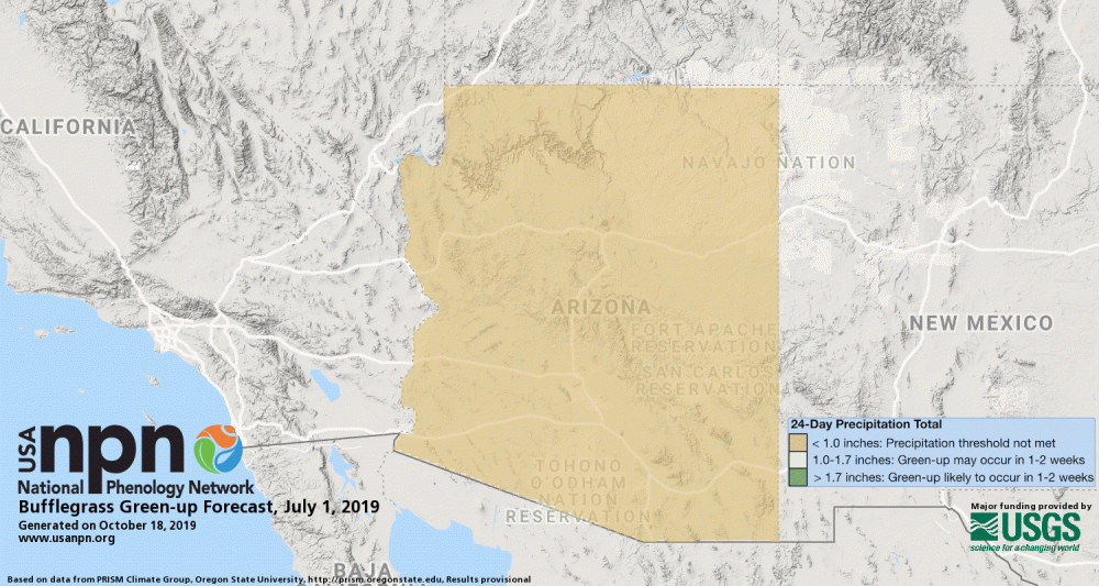
Pheno-Forecasts are also available for an invasive grasses, such as buffelgrass. The [buffelgrass Pheno-Forecast](https://usanpn.org/data/forecasts/Buffelgrass) is based on known precipitation thresholds for triggering green-up to a level where management actions are most effective. These maps are updated daily and predict green-up one to two weeks in the future.
Land Surface Phenology products
The USA-NPN offers [maps derived from MODIS 6 land surface phenology data](https://www.usanpn.org/data/land_surface_phenology). Satellite observations can be linked to in-situ observations to help understand vegetation dynamics across large spatial scales.
The MODIS Land Cover Dynamics Product (MLCD) provides global land surface phenology (LSP) data from 2001-present. MLCD serves a wide variety of applications and is currently the only source of operationally produced global LSP data. MLCD data have enabled important discoveries about the role of climate in driving seasonal vegetation changes, helped to create improved maps of land cover, and support ecosystem modeling efforts, among many other important applications.
The LSP Climate Indicators (LSP-CI) dataset is a curated collection of the most relevant phenological indicators: a measure of spring and autumn timing and a measure of seasonal productivity. Statistically robust estimates of long-term normals (median and median absolute deviation, MAD), significance-screened trends (Theil-Sen slope magnitude where p<=0.05), and interannual anomalies (in days as well as multiples of MAD) have been computed for these three phenological indicators. The data have been mosaiced across CONUS, reprojected and resampled to a more familiar spatial reference system that matches complementary datasets and delivered in the universally accessible GeoTIFF format.
## How to Access USA-NPN Data:
The USA-NPN makes the data they produce available through a number of different channels and tools. This is partly driven by the format of the data; GIS data, in many ways, can and should be managed differently than observational records, which can more easily be managed in a relational database. However, the need for these different venues is also driven by end-user need. The different tiers of tools makes the data accessible to anyone regardless of their level of technical experience. This is true from the casual observer that would like to use the visualization tool to see how their contributions to citizen science relate to the broader world, all the way to the data scientist that needs simple and standard APIs to integrate USA-NPN data into larger applications and analyses.
### The USA-NPN Landing page
A concise list of all available NPN data sets, tools, products.
### APIs
This is a set of standard web service calls that allows for programmatic access to NPN data independent of any particular programming language.
*[USA-NPN Web Service API Documentation](https://docs.google.com/document/d/1yNjupricKOAXn6tY1sI7-EwkcfwdGUZ7lxYv7fcPjO8/edit?hl=en_US)
*[USA-NPN Geoserver Documentation](https://docs.google.com/document/d/1n409GY931Pf14vNqCaeQx-Ck_5VVLH5-dVUKZ5ylVpQ/edit?usp=sharing)
*[USA-NPN GeoServer API](http://geoserver.usanpn.org/geoserver/)
### Rnpn package
This suite of R functions allows for programmatic access to both gridded and in-situ NPN data sets in an R environment. Full documentation available here: https://usa-npn.github.io/rnpn/
### Phenology Observation Portal (for observational data)
[This tool](https://www.usanpn.org/data/observational) allows users to download customized datasets of observational data from the National Phenology Database, which includes phenology data collected via the Nature's Notebook phenology program (2009-present for the United States), and additional integrated datasets, such as historical lilac and honeysuckle data (1955-present). Filters are available to specify dates, regions, species and phenophases of interest. This provides access to all phenometrics, which represents varying degrees of data aggregation.
### Geospatial Request Builder (for raster data and image files)
[This tool](https://www.usanpn.org/geoserver-request-builder) simplifies the process of accessing NPN gridded data through standard WMS and WCS services. WMS services provide the data as basic graphic images, such as PNGs or TIFFs, whereas WCS services provide the same data in formats accessible to GIS applications.
### Visualization Tool
[The Visualization Tool](https://data.usanpn.org/vis-tool/#/) provides an easier way to explore phenology data and maps. The user-friendly interface is intended to allow for searching for comparing general trends and quick-and-easy access to map data/products.
## USA-NPN Written Questions
**Suggested timing: Complete before lecture 2 of USA-NPN Hands on Coding Exercises**
**Question 1:** How might or does USA-NPN
intersect with your current research or future career goals? *(1 paragraph)*
</div>
<div id="ds-challenge" markdown="1">
**Question 2:** Use the USA-NPN visualization tool (www.usanpn.org/data/visualizations) to answer the following questions. Consider the research question that you may explore as your final semester project or a current project that you are working on and answer each of the following questions:
· Are there species, regions, or phenophases of interest to you?
· Is there geospatial phenology data that is useful for your work (e.g. Spring Indices or Growing Degree Days)?
· What is the timeframe of data you will need to address your research interests?
· What is the spatial extent of data you will need?
**Question 3:** Consider either your current or future research, or a question you’d like to address during this course:
· What climate data or additional phenological datasets would be valuable to address your research interests?
· What challenges, if any, could you foresee when beginning to work with these data?
<div id="ds-challenge" markdown="1">
## Hands on: Accessing USA-NPN Data via rNPN
### Introduction
The USA National Phenology Network (USA-NPN) is a USGS funded organization that collects phenological observation records from volunteer and professional scientists to better understand the impact of changes in the environment on the timing of species' life cycles. The USA-NPN also provides a number of raster-based climatological data sets and phenological models. These in-situ observation and geospatial, modeled datasets are available through a number of tools and data services.
The USA-NPN R library, "rnpn", is primarily a data access service for USA-NPN data products, serving as a wrapper to the [USA-NPN REST based web services](). This guide details how to use the library to access and work with all USA-NPN data types.
```{r, eval=FALSE}
install.packages("devtools")
library('devtools')
devtools::install_github("usa-npn/rnpn")
```
```{r}
library('rnpn')
```
### Accessing USA-NPN Observational Data
USA-NPN Observational data are collected on the ground by citizen and professional observers following standardized protocols, using the Nature's Notebook platform. The data are available 2009 to present, and come in four formats or data types: Status & Intensity, Individual Phenometrics, Site Phenometrics and Magnitude Phenometrics. An overview of the differences is provided in the figure below, and each type is detailed in the following sections. For a complete description of the USA-NPN approach and notes for working with each data type see the [Open File Report on USA-NPN Observational Data](https://pubs.usgs.gov/of/2018/1060/ofr20181060.pdf).
In Nature's Notebook, observers register a location, and then at each location they register any number of individual plants or animal species. The expectation is that the user then takes regular observations on each individual/species at a regular interval. Phenological status is reported by yes or no answers to a series of questions, for example, "Do you see leaves?" or "Do you see active individuals?". In contrast to traditional monitoring of annual "first" events (for example, date of first leaf or first robin), this approach captures absence data when the phenophase is not occurring and repeat events. Each observation is comprised of a series of 1, 0 and -1 values, representing yes/no/uncertain for each possible phenophase for the plant on that date. To explore data in this native "Status and Intensity" format, see the vignette by the same name.
A few considerations and functions apply across all USA-NPN Observational data types.
#### Basic format for for Observational data calls
The basic format for an observational data call in the rnpn library is:
```{r eval=FALSE}
npn_download_[NAME OF DATA TYPE] (
request_source = [NULL]
year = [NULL]
species_ID = [NULL]
)
```
'Request source' should usually be populated with your full name or the name of the organization you represent. Species_ID is the unique identifier for all the available plants and animals in the USA-NPN database.
You can create a table of all available species and their ID numbers:
```{r}
species <- npn_species()
```
Search for a species by common name from the full list:
```{r}
species[species$common_name=="red maple",]
```
There are many parameters which can be set beyond these basic ones, depending on the data type, and further detailed in the other vignettes featured in this package.
#### Required Parameters
Note that specifying the year(s) of interest is a required parameter.
There's also another required field, "request_source", which is a user-provided, self-identifying string. This allows the client to provide some information about who is accessing the data. Knowing who is using the data is very helpful for our staff to report the impact of the USA-NPN to the scientific community. The input provided here is entirely honor-based.
#### Find stations at which a species has been observed
You can also now look up which stations have a registered plant for a particular species. In the example below, we use the species ID for red maple, which we were able to find through the npn_species() function, to find all stations with that species.
```{r eval=FALSE}
npn_stations_with_spp (3)
```
### Status and Intensity Data
The Status and Intensity data type is the most direct presentation of the phenology data stored in the NPDb. Each row is comprised of a single record of the status (1/present/"Yes", 0/absent/"No" or -1/uncertain/"?") of a single phenophase on an individual plant or species of animal at a site on a single site visit, as well as the estimated intensity or abundance e.g., percent canopy fullness or number of individual robins observed respectively.
Retrieving this kind of data using this package is easy, and heavily parameterized. It's possible to filter data using a number of including year, geographic extent and species. In this example we get all records of bird observations in the New England states from 2018.
```{r eval=FALSE}
npn_download_status_data(
request_source = 'Your Name Here',
years = c('2018'),
states = c("NY","PA","VT","MA"),
functional_types = 'Bird'
)
```
'states' is an example of an optional parameter that allows you to filter data based on geographic location. Another example is 'functional_types' which allows you to get all available data for a group of similar species (e.g., all birds, shrubs or invasive species).
The best place to review **all** available optional filters is the autogenerated package description.
Another important optional parameter is called 'download_path'. By default requests for data from the services are returned as a data frame that gets stored in memory as a variable. In some cases, it makes more sense to save the data to file for easy and fast retrieval later. The download_path parameter allows you to specify a file path to redirect the output from the service, without having to fuss with pesky I/O operations. Additionally, requests made this way streams the data returned, so if the dataset you're working with is particularly large, it's possible to redirect the stream of data to file instead of loading it all into memory which can be useful if your environment doesn't have enough RAM to store the entire data set at once.
```{r eval=FALSE}
npn_download_status_data(
request_source = 'Your Name Here',
years = c('2018'),
functional_types = 'Bird',
additional_fields = 'Site_Name',
download_path ='Bird_data_2018_SiteName.csv'
)
```
Using this function to get observational records is the most basic presentation of the data, and is the most robust for doing analysis, but there are a number of other products offered through the data service which provide additional value to data end users, outlined in the next vignettes.
### Individual Phenometrics
While Status and Intensity data provide a direct and complete look at the observational data, some analyses rely on more synthesized output. Individual Phenometrics are derived from phenophase status data and provide estimates of phenophase onset and end dates based on the first and last "Yes" status values for organisms within a specified season of interest. Each row in this data type is comprised of values that are derived from a string of consecutive "Yes" status reports without an intervening "No" status report for a single phenophase for an individual plant or animal species at a site, called a "series". For plants, this data type provides information on the onset and end of a phenophase on an individual plant. For animals, it provides information on the onset and end of the presence of an animal species at a site. As animal presence at a site is much more likely to be interrupted by absence than the presence of a phenophase on a plant, Status and Intensity data or Site Phenometrics may be more appropriate for investigating animal phenology. However, we provide animal phenology in the same format as individual plants in this data type to allow users to readily compare individual plant phenology with animal activity.
Note that more than one series may exist for a given phenophase in an individual plant or animal species within a single growing season or year, this might occur in the case of leaf bud break followed by a killing frost and second round of breaking leaf buds. It could also occur at group sites where two or more observers are reporting on the same plant on sequential days but are not in agreement on phenophase status.
Any call for individual phenometrics requires chronological bounds, usually a calendar year, as determining onset and end depend on knowing what the time frame of interest is. If you query the services directly (without the benefit of this library) it's possible to specify arbitrary dates, in contrast this library allows you to specify a series of calendar years as input.
Here's an example of how to query the services for individual phenometrics data. Note that the overall structure and parameters are very similar to the call for status data. The biggest difference in this case is that start and end date parameters are now replaced with a 'years' array, which predictably takes a set of year values with which to query the service.
```{r}
npn_download_individual_phenometrics(
request_source='Your Name Here',
years=c(2013,2014,2015,2016),
species_id=c(210),
download_path="saguaro_data_2013_2016.csv"
)
```
In this example, we're able to see individual saguaro phenology for 2013 through 2016. The results returned from the service is a tabular set of records, giving start and end date by individual saguaro plant. By default, each record contains information about the location, species, phenophase, and start and end dates.
Climate data from DayMet can also be acquired with Status & Intensity, Individual Phenometrics and Site Phenometric data types, by setting the climate_data parameter to true. In this example, we are getting colored leaves (phenophase ID is 498) data for birches, using the four birch species IDs, for 2015:
```{r}
npn_download_individual_phenometrics(
request_source = 'Your Name Here',
years = c('2015'),
species_ids = c(97, 98, 99, 430),
phenophase_ids = c(498),
climate_data = TRUE,
download_path = 'Betula_data_2015.csv'
)
```
To show what this looks like, we can plot the day of year of the first observation of colored leaves in birches (genus Betula) against summer Tmax.
```{r, eval=FALSE}
BetulaLeaf <-read.csv(
'Betula_data_2015.csv',
header = TRUE,
na=-9999,
stringsAsFactors = FALSE
)
plot(
first_yes_doy~tmax_summer,
data=BetulaLeaf,
ylab=c("Day of Year"),
xlab=c("Tmax Summer"),
cex=2,
cex.axis=1.5,
cex.lab=1.5,
pch=21
)
```
### Site Phenometrics
Site Phenometrics, derived from Individual Phenometrics, provide summary metrics of the onset and end date of phenophase activity for a species at a site. Observers are directed to create sites that represent uniform habitat and are no larger than 15 acres. For plants, this metric is calculated as an average for all individuals of a species at the site. For animals, where individuals are not tracked, this metric represents the first and last recorded appearance of the species during the season of interest. For instance, if you asked for red maple leafing data, and there was a site with three red maple trees being observed, then the data would be the average onset date for all three of those red maple trees at that site.
Here's an example of how to query the services for site phenometrics data, for cloned lilacs, breaking leaf buds, 2013. The call is very similar to the call for individual phenometrics data, however, in addition you can supply the quality control filter for the number of days between a yes record and preceding no record (also applies to the last yes and following no), for the observation to be included in the calculations. Typically this is set to 7, 14 or 30, as when downloading data using the USA-NPN Phenology Observation Portal. If you do not set this parameter, it defaults to 30 days. Note that in this example the results are stored in memory, rather than output as a file.
```{r, eval=FALSE}
LilacLeafPoints2013<-npn_download_site_phenometrics(
request_source = 'Your Name Here',
years = c('2013'),
num_days_quality_filter = '30',
species_ids = '35',
phenophase_ids = '373'
)
```
In this example we're able to see the date of the first observation of breaking leaf buds for cloned lilacs, averaged across individuals within sites. If any observation did not have a preceding no record within 30 days it was excluded from the calculations.
We can now plot our cloned lilac site phenometric onset data by latitude.
```{r, eval=FALSE}
plot(
mean_first_yes_doy~latitude,
data=LilacLeafPoints2013,
ylab=c("Day of Year"),
xlab=c("Latitude"),
cex=2,
cex.axis=1.5,
cex.lab=1.5,
pch=21,
xlim=c(30,55),
ylim=c(0,200)
)
```
### Magnitude Phenometrics
Magnitude Phenometrics are a suite of eight metrics derived from Status and Intensity data. This data type provides information on the extent to which a phenophase is expressed across multiple individuals or sites, for a given set of sequential time intervals. The data user may select a weekly, bi-weekly, monthly, or custom time interval to summarize the metrics. Two metrics are available for both plants and animals, one metric is available for plants alone and five metrics are available for animals alone (table 1). Three of the five animal metrics correct animal abundance values for observer effort in time and space.
Here's an example of how to query for Magnitude Phenometrics, for the active individuals phenophase for black-capped chickadee data, in 2018. Requirements are similar to other data types. You must additionally specify the time interval by which the data should be summarized. Typically this is weekly, biweekly or monthly, as in the POP and Visualization Tool. The interval chosen in this example is 7 days.
```{r, eval=FALSE}
npn_download_magnitude_phenometrics(
request_source = 'Your Name Here',
years = '2018',
period_frequency = "7",
species_ids = '245',
phenophase_ids = '292',
download_path = 'MPM_BCC_ActInd_2018.csv'
)
```
In this example we're able to see all of the magnitude phenometric fields, including proportion_yes_records, and mean_num_animals_in-phase. See the [https://pubs.usgs.gov/of/2018/1060/ofr20181060.pdf](Open File Report on USA-NPN Observational Data) for full field descriptions.
From this dataset we can view the Proportion_Yes_Records (of all the records submitted on this species, what proportion are positive/yes records) by weekly interval:
```{r, eval=FALSE}
BCC_AI<-read.csv(
'MPM_BCC_ActInd_2018.csv',
header = TRUE,
na=-9999,
stringsAsFactors = FALSE
)
plot(
BCC_AI$proportion_yes_record~as.Date(BCC_AI$start_date,"%Y-%m-%d"),
ylab=c("Proportion Yes Records"),
xlab=c("Date"),
cex=2,
cex.axis=1.5,
cex.lab=1.5,
pch=21,
xlim=as.Date(c("2018-01-01", "2018-08-01")),
ylim=c(0,1)
)
```
### USA-NPN Geospatial Data
USA-NPN provides phenology-relevant climate data in raster format. There are two main suites of products in this category: Accumulated Growing Degree Days and Extended Spring Indices. Accumulated Growing Degree Days and the Extended Spring Indices are both representations of accumulated temperature. As accumulated winter and spring heat drives many spring season phenological events in much of the country, these products can be used to better understand patterns in the current and historical timing of these events across the landscape. For a complete description of the USA-NPN approach and notes for working with each data type see the [Open File Report](https://pubs.usgs.gov/of/2017/1003/ofr20171003.pdf) on USA-NPN Gridded Data.
Both suites are available as:
* Current year value, with a 6-day forecast
* Current year anomaly, with a 6-day forecast
* Long-term (30 year) average
* Historical years
+ AGDD - 2016-Prior Year
+ Extended Spring Index - 1880-Prior Year
All of these products can be downloaded using the npn_download_geospatial call. There is a number of other products and permutations of the above listed AGDD and Spring Index products, so you can get a complete list of available layers and additional details about them including resolution, extent and the abstract/layer description.
```{r}
layers <- npn_get_layer_details()
```
The following sections describe how to parameterize calls for both AGDD and Spring Index layers. These calls result in raster data sets for the contiguous United States.
If you are interested in how many GDDs had accumulated when the red maple in your backyard leafed out, or what day the Spring Index requirements for leaf out were met for your location, you may wish to query the layers for these values, based on location and date. There are two ways to accomplish this, using the npn_get_point_data function which works for all layers and the npn_get_AGDD_point_data function, which only works for AGDD layers and provides a more precise result.
```{r, eval=FALSE}
npn_get_agdd_point_data(
'gdd:agdd_50f',
'38',
'-90',
'2019-02-25'
)
```
This returns a value of 7.64098 GDD, base 50F, for the coordinates 38 north, -90 west on February 25th, 2019.
```{r}
npn_get_point_data(
'si-x:lilac_bloom_ncep',
'30',
'-90',
'2019-02-25'
)
```
This returns a value for lilac bloom of day 48, for the coordinates 30 north, -90 west, as of February 25th, 2019.
The above mentioned AGDD products use base temperatures of 32F or 50F and are managed through WCS services. There is also a function to get dynamic AGDD calculations based on a user defined base temperature and a number of other parameters.
```{r, eval=FALSE}
custom_agdd_raster <- npn_get_custom_agdd_raster(
method = 'double-sine',
climate_data_source = 'NCEP',
temp_unit = 'fahrenheit',
start_date = '2019-01-01',
end_date = '2019-05-10',
base_temp = 20,
upper_threshold = 90
)
```
## Accumulated Growing Degree Day Products
Heat accumulation is commonly used as a way of predicting the timing of phenological transitions in plants and animals, including when plants exhibit leaf out, flowering, or fruit ripening, or when insects emerge from dormancy. This is typically expressed as accumulated heat units, either Growing Degree Hours or Growing Degree Days. Growing degree day thresholds have been established for many species, and are commonly used in agriculture, horticulture, and pest management to schedule activities such as harvesting, pesticide treatment, and flower collection. The USA-NPN is currently generating Accumulated Growing Degree Days (AGDD) rasters using a January 1 start date, calculated using simple averaging. These are available calculated using two base temperatures, 32 degrees Fahrenheit (F) and 50 F.
When querying certain layers, the underlying data is agnostic about the specific year, and in these cases it makes sense to use the day of year to request data, since that will provide a standardized result, (i.e., April 1st is day 91 in some years and day 92 in others).
```{r, eval=FALSE}
npn_download_geospatial(
'gdd:30yr_avg_agdd_50f',
95
)
```
But if you're looking at a specific year, such as a current year layer, it makes sense to use a specific calendar date (formatted YYYY-MM-DD). It's also possible to save the raster directly to file instead of loading it into memory.
```{r, eval=FALSE}
npn_download_geospatial(
'gdd:agdd',
'2018-05-05',
output_path='20180505-agdd-value.tiff'
)
```
In the case of the historic Spring Index layers, however, the product represents the overall outcome for the entire year, so while the year component of the date matters, the month and day do not. In this case, specify January 1 as the month and date.
```{r, eval=FALSE}
npn_download_geospatial(
"si-x:average_bloom_prism",
"1995-01-01"
)
```
The dimension.range value, returned in the npn_get_layer_details() function, clarifies the full set of applicable dates for each layer.
Of course, it's also easy to grab raster data and load it into a visual plot as in this example, showing a map of AGDD base 50 on 2019-06-25:
```{r, warning = FALSE, message=FALSE}
AGDDJun2019<-npn_download_geospatial(
'gdd:agdd_50f',
'2019-06-25'
)
```
```{r, eval=FALSE}
plot(
AGDDJun2019,
main = "AGDD base 50 on June 25th, 2019"
)
```
An important layer to know of is the 30 year average for AGDD products. This is useful for many comparative analyses. This layer takes DOY as the date input, since it's the average AGDD value for each day of year for 1981 - 2010.
```{r, eval=FALSE}
average_30yr <- npn_download_geospatial(
"gdd:30yr_avg_agdd",
45
)
```
## Extended Spring Indices
The Extended Spring Indices are mathematical models that predict the "start of spring" (timing of first leaf or first bloom) at a particular location. These models were constructed using historical observations of the timing of first leaf and first bloom in a cloned lilac cultivar (Syringa X chinensis 'Red Rothomagensis') and two cloned honeysuckle cultivars (Lonicera tatarica L. 'Arnold Red' and Lonicera korolkowii Stapf, also known as 'Zabelii'), which were selected based on the availability of historical observations from across a wide geographic area. Primary inputs to the model are temperature and weather events, beginning January 1 of each year. The model outputs are first leaf and first bloom date for a given location.
Data for the Spring Index is available through an enumeration of layers that represents each of the three sub-models as well as an 'average' model which represents the aggregation of the three sub-models. These layers are further enumerated by both of the represented phenophases, leaf and bloom. In the example below, first the layer representing only the Arnold Red model for 1987 is retrieved, while the second function call gets the model averaging all three of the models for the same year.
```{r eval=FALSE}
npn_download_geospatial(
"si-x:arnoldred_bloom_prism",
"1987-01-01"
)
average_model <- npn_download_geospatial(
"si-x:average_bloom_prism",
"1987-01-01"
)
```
The Spring Indices are also unique in that the algorithm has been run against the BEST climate data set, so historic data going back to 1880 is available.
```{r, warning = FALSE, eval=FALSE}
BESTSIxData1905 <- npn_download_geospatial(
'si-x:average_bloom_best',
'1905-01-01'
)
NAvalue(BESTSIxData1905) <- -9999
```
```{r, eval=FALSE}
plot(
BESTSIxData1905,
main = "Spring Index, 1905"
)
```
### Other Layers
Besides the AGDD and Spring Index layers there are a number of other useful layers available through these services, including daily temperature minimum and maximums and aggregated MODISv6 phenometrics.
The daily temperature minimum and maximum values are the underlying climate data used to generate current year AGDD and Spring Index maps. These data are generated by NOAA's National Centers for Environmental Prediction (NCEP) and are reserved through NPN's geospatial services.
```{r, eval=FALSE}
daily_max_20190505 <- npn_download_geospatial(
'climate:tmax',
'2019-05-05'
)
plot(
daily_max_20190505,
main = "Daily Temperature Max (C), May 5th, 2019"
)
```
The MODISv6 layers are aggregate values for remote sensing values from the MODISv6 data set, representing a subset of the following phenometrics, aggregated across 2001 - 2017: EVI Area, Mid-Greenup, Mid-Greendown. The available aggregate values for each layer are: median, TSslope, and mean absolute deviation.
This example shows the median green up value, as DOY. Note that because this layer has a fixed date, the date parameter is input as a blank string.
```{r, eval=FALSE}
median_greenup <- npn_download_geospatial(
'inca:midgup_median_nad83_02deg',
''
)
plot(
median_greenup,
main = "MODIS Median Mid-Greenup, 2001 - 2017"
)
```
## Putting it all together:
## Combine Point and Raster Data
Observational and gridded data can be visualized or analyzed together for a variety of purposes. Users may want to identify spatial patterns in the alignment of dogwood bloom and the Spring Index bloom model. The current year's lilac leaf out observations may be compared to the 30 year average lilac sub-model of the spring index to see how well the model predicts the observations.
This example shows several data access calls to assemble observational and gridded data.
Option 1: You can add a parameter to an observational data call to additionally get a gridded layer value for each observation location/date. Note that if you don't specify which sub model of the Spring Index you want, you will get the SI-x Average layers.
```{r, eval=FALSE}
npn_download_site_phenometrics(
request_source = 'Your Name Here',
years = '2013',
num_days_quality_filter = '30',
species_ids = '35',
phenophase_ids = '373',
download_path = 'cl_lilac_data_2013_SIxLeaf.csv',
six_leaf_layer = TRUE,
six_sub_model = 'lilac'
)
```
If you want to append raster data other than Spring Index, Leaf values, there's alternative boolean flags that can be set, including six_bloom_layer for Spring Index, Bloom data, and agdd_layer. Instead of TRUE or FALSE agdd_layer takes 32 or 50 and will correlate each data point with the corresponding AGDD value for the given date using either 32 or 50 base temperature.
Option 2: You can create a combined plot of observational data with modeled/raster data.
Building on the approach for accessing point data from earlier vignettes describing Individual Phenometrics and getting raster data, we can access and plot these products together. In this example, we will look at how well cloned lilac leaf out observations in 2018 are predicted by the lilac leaf sub model of the Spring Index.
### Step 1: Get the data
```{r, eval=FALSE}
LilacLeaf2018<-npn_download_geospatial(
'si-x:lilac_leaf_ncep',
'2018-12-31',
)
LilacLeaf2018Obs <-npn_download_individual_phenometrics(
request_source = 'Your Name Here',
years = '2018',
species_ids = '35',
phenophase_ids = '373'
)
```
### Step 2: Preparing the data
```{r, eval=FALSE}
coords <- LilacLeaf2018Obs[ , c("longitude", "latitude")]
data <- as.data.frame(LilacLeaf2018Obs$first_yes_doy)
crs <- CRS("+proj=utm +zone=18 +datum=WGS84 +units=m +no_defs
+ellps=WGS84 +towgs84=0,0,0")
LL_spdf <- SpatialPointsDataFrame(
coords = coords,
data = data,
proj4string = crs
)
```
### Step 3: Define style options and create graph
```{r, eval=FALSE}
my.palette <- brewer.pal(n=9,name="OrRd")
plot(
LilacLeaf2018,
col = my.palette,
main="2018 Observed and Predicted Lilac Leaf Out"
)
plot(
LL_spdf,
main="Lilac Obs",
pch = 21,
bg = my.palette,
col = 'black',
xlim=c(-125.0208,-66.47917),
ylim=c(24.0625 ,49.9375),
add = TRUE
)
legend(
"bottomright",
legend=c("Cloned Lilac Leaf Out Observations"),
pch = 21,
bg = 'white',
col = 'black',
bty="n",
cex=.8
)
```
## Live Demo Code with Lee Marsh of USA-NPN
### Basic Utility Functions
```{r, eval=FALSE}
species <- npn_species()
phenophases <- npn_phenophases()
layer_details <- npn_get_layer_details()
```
```{r, eval=FALSE}
quick_get_phenophase <- function(species_id, date,phenophase_name){
phenophases<-npn_phenophases_by_species(c(species_id),date=date)
phenophases_species <- phenophases[phenophases$species_id==species_id]$phenophases[[1]]
phenophases_species[phenophases_species$phenophase_name==phenophase_name,]$phenophase_id
}
quick_get_species <- function(species_name){
species[species$common_name==species_name,]$species_id
}
```
### Download Observational Data
```{r, eval=FALSE}
white_oak_id <- quick_get_species("white oak")
fruits_id<- quick_get_phenophase(white_oak_id,"2017-05-15","Fruits")
# Raw data download
s2017_white_oak_raw <- npn_download_status_data(
request_source = "R Demo",
years = c(2017),
species_ids = c(white_oak_id),
phenophase_ids = c(fruits_id)
)
```
### Magnitude Data
```{r, eval=FALSE}
m2017_white_oak_magnitude <- npn_download_magnitude_phenometrics(
request_source = "INF550",
years = c(2017),
species_ids = c(white_oak_id),
phenophase_ids = c(fruits_id),
period_frequency = "14"
)
datasets <- npn_datasets()
# NEON data, file download, additional fields
npn_download_status_data(
request_source = "R Demo",
years = c(2018:2020),
states = c("CO"),
dataset_ids = c(16),
additional_fields = c("Site_Name"),
download_path = "NEON_CO_Data_2018-2010.csv"
)
```
### Downloading Geospatial Data
```{r, eval=FALSE}
SIXBloom2018 <- npn_download_geospatial(
'si-x:average_bloom_ncep',
'2018-12-31'
)
npn_download_geospatial(
'gdd:agdd',
'2018-04-15',
output_path = "20180415-32-agdd.tiff"
)
my_point <- npn_get_point_data("gdd:agdd_50f", 33.649, -111.861, "2017-05-15")
```
### Putting it together
```{r, eval=FALSE}
dogwood_id <- quick_get_species("flowering dogwood")
dogwood_flowering_id <-
quick_get_phenophase(dogwood_id,"2018-05-05","Flowers or flower buds")
dogwood_data <- npn_download_site_phenometrics(
request_source = 'Demo',
years = '2018',
species_ids = dogwood_id,
phenophase_ids = dogwood_flowering_id,
six_leaf_layer = TRUE,
agdd=32
)
```
### Other Data Sources, e.g. Daymet, MODIS
```{r, eval=FALSE}
add_fields <- npn_download_status_data(
request_source = "INF550",
years = c(2014),
species_id = c(4),
additional_fields = c("tmaxf","Greenup_0","MidGreenup_0")
)
```
## USA-NPN Coding Lab
```{r, quiet=TRUE, warnings=FALSE, results=FALSE}
library(rnpn)
library(ggplot2)
library(neonUtilities)
library(dplyr)
source('/Users/kdw223/Research/Environmental-Informatics-Using-Research-Infrastructures-and-their-Data/neon_token_source.R')
```
1. For the purposes of this exercise we will be focusing on two NEON sites: `HARV` and `CPER`. Save these two sites into your workplace so that you can feed them into functions and packages.
2. Define AGGD and write the equation using LaTeX. What is an appropriate time interval over which we should calculate AGGD? *This will be relevant for following questions*
3. Use the `neonUtilities` package to pull plant phenology observations (DP1.10055.001). We will work with the `statusintensity` data:
Hints:
```{r, quiet=TRUE, results=FALSE}
#TOS Phenology Data
sitesOfInterest <- c("HARV")
dpid <- as.character('DP1.10055.001') #phe data
pheDat <- loadByProduct(dpID="DP1.10055.001",
site = sitesOfInterest,
package = "basic",
check.size = FALSE,
token=NEON_TOKEN)
#NEON sends the data as a nested list, so I need to undo that
# unlist all data frames
list2env(pheDat ,.GlobalEnv)
summary(phe_perindividualperyear)
summary(phe_statusintensity)
#remove duplicate records
phe_statusintensity <- select(phe_statusintensity, -uid)
phe_statusintensity <- distinct(phe_statusintensity)
```
```{r}
library(lubridate)
#Format dates
phe_statusintensity$date <- as.Date(phe_statusintensity$date, "%Y-%m-%d")
phe_statusintensity$editedDate <- as.Date(phe_statusintensity$editedDate, "%Y-%m-%d")
phe_statusintensity$year <- as.numeric(substr(phe_statusintensity$date, 1, 4))
phe_statusintensity$month <- as.numeric(format(phe_statusintensity$date, format="%m"))
```
In your `phe_statusintensity` data.frame pick a phenophase name of interest:
```{r}
unique(phe_statusintensity$phenophaseName)
```
And select a single taxon:
```{r}
unique(phe_perindividual$taxonID)
```
Now create a new, filtered `dataframe` only including those observations and print a summary. You'll also want to filter for typical things like `NA` values, and think about how you'll work with data that comes in factors or strings. Are there ways you could extract numerical values for plotting? Could you `count` data? Summarize your strategy.
4. Using dpid **DP1.00002.001** Single Aspirated Air Temperature calculate AGGD based on NEON tower data over the time period you decidided upon in question 1. To save you time and frustration I've placed some **mostly complete** example code for *one* height on the tower *just for Harvard*. **You will need to determine which height you think it best and conmplete these calculations for both sites.** You will also need to consder things like filtering your temperature data for quality flags, and converting from GMT (Greenwich Mean Time) to [your location's time](https://stackoverflow.com/questions/1395117/how-do-you-convert-dates-times-from-one-time-zone-to-another-in-r):
```{r libraries, eval=FALSE}
##load libraries
#library(tidyverse)
library(neonUtilities)
#install.packages('mgcv')
library(mgcv)
```
```{r, eval=FALSE}
dpid <- as.character('DP1.00002.001') ##single aspirated air temperature
tempDat <- loadByProduct(dpID=dpid,
site = "HARV",
startdate = "2017-01",
enddate="2017-12",
avg=30,
package = "basic",
check.size = FALSE)
df <- tempDat$SAAT_30min
```
```{r, eval=FALSE}
# GDD typically reported in F
# convert df temps
df$meanTempF=df$tempSingleMean*1.8+32
#pull date value from dateTime
df$date <- substr(df$endDateTime, 1, 10)
```
**Group data and summarize values**
Here, I will group the 30-minute temperature averages by data (to get daily values)
**You will want to consider which vertical position is most appropriate to use for your analysis.**
You can view the sensor position data in the sensor_positions table downloaded above, where HOR.VER are the horizontal and vertical position indices (separated by a period),and zOffset is in meters above the ground:
```{r, eval=FALSE}
select(tempDat$sensor_positions_00002, c(HOR.VER, zOffset))
```
you can also view all of the sensor position info with the following line:
```{r, eval=FALSE}
head(tempDat$sensor_positions_00002)
```
For example, the lowest position sensor (verticalPosition == 010) may be most appropriate for comparison with the phenological state of very short plants, while the highest verticalPosition may be better for comparison with canopy trees.
Here I'll select level 1 for demonstration
```{r, eval=FALSE}
day_temp <- df%>%
filter(verticalPosition=="010")%>%
group_by(siteID, date)%>%
mutate(dayMaxTemp=max(meanTempF), dayMinTemp=min(meanTempF),
dayMeanTemp=mean(meanTempF))%>%
select(siteID, date, dayMaxTemp, dayMinTemp, dayMeanTemp)%>%
distinct()
##alternative, simplified mean, consistent with many GDD calculations
### does accumulation differ for true mean vs. simplified mean?
day_temp$mean2 <- (day_temp$dayMinTemp + day_temp$dayMaxTemp)/2
```
**Caluculate daily GDD for a true mean**
*50 degrees F is a common base temperature used to calculate plant specific GDD. When might you select a different base temp?*
*How might you want to deal with different 'means' of temperature? A couple of options below:*
```{r, eval=FALSE}
day_temp$GDD1 <- ifelse(day_temp$dayMeanTemp-50 < 0, 0, round(day_temp$dayMeanTemp-50, 0))
day_temp$GDD2 <- ifelse(day_temp$mean2-50 < 0, 0, round(day_temp$mean2-50, 0))
day_temp$GDD3 <- ifelse(day_temp$dayMeanTemp-50 < 0, 0, round(day_temp$mean2-50, 0))