Skip to content
New issue

Have a question about this project? Sign up for a free GitHub account to open an issue and contact its maintainers and the community.

By clicking “Sign up for GitHub”, you agree to our terms of service and privacy statement. We’ll occasionally send you account related emails.

Already on GitHub? Sign in to your account

Inconsistent number of decimal places in Identify tool #27929

Closed
qgib opened this issue Oct 14, 2018 · 6 comments · Fixed by #47173
Closed

Inconsistent number of decimal places in Identify tool #27929

qgib opened this issue Oct 14, 2018 · 6 comments · Fixed by #47173
Labels
Bug Either a bug report, or a bug fix. Let's hope for the latter! Map Tools Related to non-digitizing map tools

Comments

@qgib
Copy link
Contributor

qgib commented Oct 14, 2018

Author Name: Andrea Giudiceandrea (@agiudiceandrea)
Original Redmine Issue: 20107
Affected QGIS version: 3.6.0
Redmine category:map_tools


In QGIS 3.3.0-Master, using the Identify tool, the Length, Area and Perimeter values are displayed always with 3 decimal places, while the other values are displayed according to the settings in Project Properties | General | Coordinate Display | Precision.

image

PR #7836 previously created.


@qgib
Copy link
Contributor Author

qgib commented Oct 14, 2018

Author Name: Andrea Giudiceandrea (@agiudiceandrea)


  • description was changed from In QGIS 3.3.0-Master, using the Identify tool, the Length, Area and Perimeter values are displayed always with 3 decimal places, while the other values are displayed according to the settings in Project Properties | General | Coordinate Display | Precision.

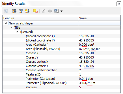
[[https://issues.qgis.org/attachments/download/20107/QGIS330_2.PNG]]

PR #7836 previously created. to In QGIS 3.3.0-Master, using the Identify tool, the Length, Area and Perimeter values are displayed always with 3 decimal places, while the other values are displayed according to the settings in Project Properties | General | Coordinate Display | Precision.

[[https://issues.qgis.org/attachments/download/13499/QGIS330_2.PNG]]

PR #7836 previously created.

@qgib
Copy link
Contributor Author

qgib commented Oct 14, 2018

Author Name: Andrea Giudiceandrea (@agiudiceandrea)


  • description was changed from In QGIS 3.3.0-Master, using the Identify tool, the Length, Area and Perimeter values are displayed always with 3 decimal places, while the other values are displayed according to the settings in Project Properties | General | Coordinate Display | Precision.

[[https://issues.qgis.org/attachments/download/13499/QGIS330_2.PNG]]

PR #7836 previously created. to In QGIS 3.3.0-Master, using the Identify tool, the Length, Area and Perimeter values are displayed always with 3 decimal places, while the other values are displayed according to the settings in Project Properties | General | Coordinate Display | Precision.

!https://issues.qgis.org/attachments/download/13499/QGIS330_2.PNG!

PR #7836 previously created.

@qgib
Copy link
Contributor Author

qgib commented Oct 28, 2018

Author Name: Andrea Giudiceandrea (@agiudiceandrea)


Confirmed on 3.4.0


  • version was changed from 3.3(master) to 3.4.0

@qgib
Copy link
Contributor Author

qgib commented Oct 28, 2018

Author Name: Giovanni Manghi (@gioman)


reopen the PR?


  • status_id was changed from Open to Feedback

@qgib
Copy link
Contributor Author

qgib commented Mar 9, 2019

Author Name: Giovanni Manghi (@gioman)


This is still true in the latest versions, not sure why the PR was closed.


  • version was changed from 3.4.0 to 3.6.0
  • status_id was changed from Feedback to Open

@qgib qgib added Bug Either a bug report, or a bug fix. Let's hope for the latter! Map Tools Related to non-digitizing map tools labels May 25, 2019
@Pedro-Murteira
Copy link

Still true on QGIS 3.16.14 and 3.22.1.

elpaso added a commit that referenced this issue Feb 4, 2022
Homogenize number of decimal places in Identify tool (fix #27929)
Sign up for free to join this conversation on GitHub. Already have an account? Sign in to comment
Labels
Bug Either a bug report, or a bug fix. Let's hope for the latter! Map Tools Related to non-digitizing map tools
Projects
None yet
Development

Successfully merging a pull request may close this issue.

2 participants