Here you will find all the relevant information regarding the dataset introduced in our paper:
Álvarez-Tuñón, O., Kanner, H., Marnet, L. R., Pham, H. X., le Fevre Sejersen, J., Brodskiy, Y., & Kayacan, E. (2023, October). Mimir-uw: A multipurpose synthetic dataset for underwater navigation and inspection. In 2023 IEEE/RSJ International Conference on Intelligent Robots and Systems (IROS) (pp. 6141-6148). IEEE.
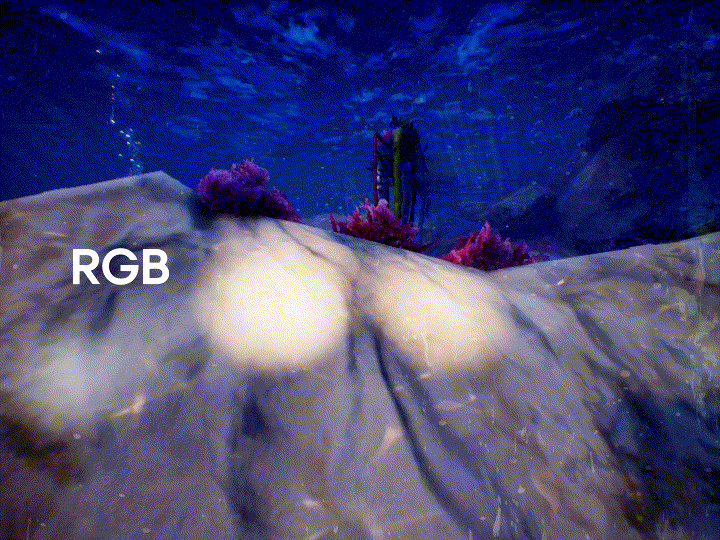
| Simulated underwater robot | 3 cameras x 3 sensors | 4 environments |
|---|---|---|
 |
 |
 |

This work is part of the Reliable AI for Marine Robotics (REMARO) Project. For more info, please visit: https://remaro.eu/

This project has received funding from the European Union's Horizon 2020 research and innovation programme under the Marie Skłodowska-Curie grant agreement No. 956200.
You can download MIMIR-UW from the following link
 |
 |
 |
 |
The data tree is shown below. For the sake of brevity, we only show the nested structured under one of the tracks for one of the sequences, that is, under track0 for the SeaFloor sequence. Similarly, we only show the nested structure under one of the cameras. Note that the structure is the same for all cameras and sequences.
MIMIR-UW
├── SeaFloor
│   ├── segmentation.json
│   ├── settings.json
│   └── auv0
│   │   ├── track0
│   │   │   ├── imu0
│   │   │   │   └── data.csv
│   │   │   ├── pose_groundtruth
│   │   │   │   └── data.csv
│   │   │   ├── rgb
│   │   │   │   ├── cam0
│   │   │   │   │   ├── data
│   │   │   │   │   │   ├── <filename0>.png
│   │   │   │   │   │   ├── ...
│   │   │   │   │   │   └── <filenameN>.png
│   │   │   │   │   ├── data.csv
│   │   │   │   │   └── sensor.yaml
│   │   │   │   ├── cam1
│   │   │   │   └── cam2
│   │   │   ├── segmentation
│   │   │   │   ├── cam0
│   │   │   │   │   ├── data
│   │   │   │   │   │   ├── <filename0>.png
│   │   │   │   │   │   ├── ...
│   │   │   │   │   │   └── <filenameN>.png
│   │   │   │   │   ├── data.csv
│   │   │   │   │   └── sensor.yaml
│   │   │   │   ├── cam1
│   │   │   │   └── cam2
│   │   │   └── depth
│   │   │   │   ├── cam0
│   │   │   │   │   ├── data
│   │   │   │   │   │   ├── <filename0>.exr
│   │   │   │   │   │   ├── ...
│   │   │   │   │   │   ├── <filenameN>.exr
│   │   │   │   │   ├── data.csv
│   │   │   │   │   └── sensor.yaml
│   │   │   │   ├── cam1
│   │   │   │   └── cam2
│   │   ├── track1
│   │   └── track2
├── SeaFloor_Algae
│   ├── track0
│   ├── track1
│   └── track2
├── OceanFloor
│   ├── track0_light
│   ├── track0_dark
│   └── track1_light
├── SandPipe
│   └── track0_light
│   └── track0_dark
└── README.md
We follow a dataset format similar to the ASL format proposed by EuRoC. We provide calibration files for all available sensors, with temporally aligned ground truth and measurements. The calibration files are provided as a sensor.yaml file. For the camera, the data is comprised as follows:
{
    "sensor_type": "front_left",
    "comment": "rgb",
    "T_BS": [
        [0.9659258262890682, -0.0, -0.25881904510252074, 0.45],
        [0.0, 1.0, -0.0, -0.06],
        [0.25881904510252074, 0.0, 0.9659258262890682, 0.0],
        [0.0, 0.0, 0.0, 1.0]
    ],
    "rate_hz": 30,
    "resolution": [
        720,
        540
    ],
    "camera_model": "pinhole",
    "intrinsics": [
        [252.07470703125, 0.0, 360.0],
        [0.0, 252.07470703125, 270.0],
        [0.0, 0.0, 1.0]
    ],
    "distortion_model": "radial-tangential",
    "distortion_coefficients": [
        0.0,
        0.0,
        0.0,
        0.0,
        0.0
    ]
}
And for the IMU:
{
    "sensor_type": "imu0",
    "T_BS": [
        [1.0, 0.0, 0.0, 0.0],
        [0.0, 1.0, 0.0, 0.0],
        [0.0, 0.0, 1.0, 0.0],
        [0.0, 0.0, 0.0, 1.0]
    ],
    "rate_hz": 210,
    "angular_random_walk": 0.3,
    "giro_bias_stability_tau": 500,
    "giro_bias_stability": 4.6,
    "velocity_random_walk": 0.24,
    "accel_bias_stability": 36,
    "accel_bias_stability_tau": 800
}
With T_BS the transform between body and sensor frame.
In our paper, we evaluate the performance of ORB-SLAM3 and DSO in MIMIR-UW. If you wish to run the experiments in your own computer, you can find forks for both repositories under evaluation/SLAM. These forks provide all the files required by each repository, plus script files to easily run the algorithms on MIMIR-UW.
You can use the settings file for AirSim provided in this repo by creating a symlink as follows:
```
ln -s ~/MIMIR-UW/SeaFloor/settings.json ~/Documents/AirSim/settings.json
```