Intro to Zarr & Xarray


Zarr is a file format for storing multi-dimensional arrays that is optimized for large datasets in cloud computing environments. It is similar in concept to Cloud Optimized Geotiffs and Cloud Optimized Point Clouds, but for large multi-dimensional arrays. When stored in object cloud storage, portions of Zarr files (known as chunks) can be streamed into client applications like a jupyter notebook for analysis. This allows us to work with datasets without having to download them to our local computer.


In the geopspatial world, Zarr format is an efficient way to store and share large array datasets. One example could be hyperspectral imagery where the X and Y dimensions represent geographic coordinates, and the 3rd dimension represents hundreds of spectral bands.

Another example for Zarr is meteorological or weather data across the geographic space. The X and Y dimensions could show the variable temperature, and the 3rd dimension could be time-steps (perhaps hundreds of them).

Zarr is like NetCDF-4 in capturing and expressing metadata and data, but it is more flexible than Parquet because it allows for chunking along any dimension. Zarr arrays function like NumPy arrays, but the data is divided into chunks and compressed. It provides similar functionality to HDF5 but with additional flexibility. Zarr offers powerful compression options, supports multiple data store backends, and can read/write NumPy arrays in parallel.
Here are some of the benefits of using Zarr:
- Efficient for large datasets
- Well-suited for cloud computing environments
- Chunked format
- Compressed format
- Hierarchical format
- Versioning support
- Portable format
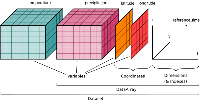
Xarray is the python library you use to work with Zarr format. Xarray is an open source project in Python that extends Pandas, to handle multidimensional data structures that are used in the physical sciences. Xarray integrates labels in the form of dimensions, coordinates and attributes to multidimensional arrays.
Xarray expands on the capabilities on NumPy arrays, providing a lot of streamlined data manipulation. It is similar in that respect to Pandas, but whereas Pandas excels at working with dataframes, Xarray is focused on N-dimensional arrays of data (i.e. grids). Its interface is based largely on the netCDF data model (variables, attributes, and dimensions), but it goes beyond the traditional netCDF interfaces to provide functionality similar to netCDF-java’s Common Data Model (CDM).
Xarrays have two core data structures:
- DataArray, which is a N-dimensional array with labeled coordinates and dimensions. It is a N-dimenisonal generalization of a Pandas.Series.
- Dataset, which is a multidimensional in-memory array database.
The following notebook demonstrates the use of Zarr and Xarray. We will use Daymet climate data from NASA. Daymet provides gridded (1 km x 1 km) estimates of daily weather data across North America. Variables include the following parameters: minimum temperature, maximum temperature, precipitation, shortwave radiation, vapor pressure, snow water equivalent, and day length.
- Xarray Documentation.
- Xarray Tutorial
- Xarray User Guide
- Xarray API Reference
- Xarray. Project Pythia.
- Introduction to Python - ARGO float data. Ocean Data Labs. Rutgers University.

