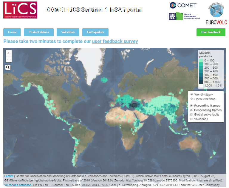
LiCSBAS is an open-source package in Python and bash to carry out InSAR time series analysis using LiCSAR products (i.e., unwrapped interferograms and coherence) which are freely available on the COMET-LiCS web portal. LiCSBAS2 is the successor of LiCSBAS.
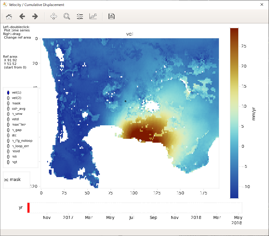
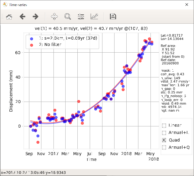
Users can easily derive the time series and velocity of the displacement if sufficient LiCSAR products are available in the area of interest. LiCSBAS also contains visualization tools to interactively display the time series of displacement to help investigation and interpretation of the results.
THIS IS RESEARCH CODE PROVIDED TO YOU "AS IS" WITH NO WARRANTIES OF CORRECTNESS. USE AT YOUR OWN RISK.
WIP
If you have found an issue or bug, please report it on the issues page.
Morishita, Y.; Lazecky, M.; Wright, T.J.; Weiss, J.R.; Elliott, J.R.; Hooper, A. LiCSBAS: An Open-Source InSAR Time Series Analysis Package Integrated with the LiCSAR Automated Sentinel-1 InSAR Processor. Remote Sens. 2020, 12, 424, https://doi.org/10.3390/RS12030424 (Remote Sensing 2022 Best Paper Award).
Morishita, Y.: Nationwide urban ground deformation monitoring in Japan using Sentinel-1 LiCSAR products and LiCSBAS. Prog. Earth Planet. Sci. 2021, 8, 6, https://doi.org/10.1186/s40645-020-00402-7.
Lazecký, M.; Spaans, K.; González, P.J.; Maghsoudi, Y.; Morishita, Y.; Albino, F.; Elliott, J.; Greenall, N.; Hatton, E.; Hooper, A.; Juncu, D.; McDougall, A.; Walters, R.J.; Watson, C.S.; Weiss, J.R.; Wright, T.J. LiCSAR: An Automatic InSAR Tool for Measuring and Monitoring Tectonic and Volcanic Activity. Remote Sens. 2020, 12, 2430, https://doi.org/10.3390/rs12152430.
Morishita, Y., Sugimoto, R., Nakamura, R. et al. Nationwide urban ground deformation in Japan for 15 years detected by ALOS and Sentinel-1. Prog Earth Planet Sci 10, 66 (2023). https://doi.org/10.1186/s40645-023-00597-5
This work has been accomplished during Y. Morishita’s visit to the University of Leeds, funded by JSPS Overseas Research Fellowship.
COMET is the UK Natural Environment Research Council's Centre for the Observation and Modelling of Earthquakes, Volcanoes and Tectonics. LiCSAR is developed as part of the NERC large grant, "Looking inside the continents from Space" (NE/K010867/1). LiCSAR contains modified Copernicus Sentinel data [2014-] analysed by the COMET. LiCSAR uses JASMIN, the UK’s collaborative data analysis environment.
The Scientific Colour Maps (Crameri, 2018) is used in LiCSBAS.
Yu Morishita (PhD)
JSPS Overseas Research Fellow (June 2018-March 2020)
Visiting Researcher, COMET, School of Earth and Environment, University of Leeds (June 2018-March 2020)
Chief Researcher, Geography and Crustal Dynamics Research Center, Geospatial Information Authority of Japan (GSI) (April 2020-March 2022)
Visiting Researcher, Digital Architecture Research Center, National Institute of Advanced Industrial Science and Technology (AIST) (May 2022-)
![]()
![]()
![]()