Releases: OpenOrienteering/mapper
v0.9.5

All changes since previous release build
We are proud to announce the release of OpenOrienteering Mapper 0.9.5. This official release includes bug fixes and new features. Key changes since v0.9.4 are:
Enhancements
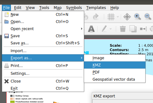
- Mapper finally learned to export KMZ files (GH-138). These files can also be used as templates.
- For organisers of MapRun or Vikazimut events, the KMZ export is complemented by a "Simple Course" export feature, turning a single line object (course) into a KML or IOF Data Standard 3.0 course file.
- Geospatial vector data export formats can be selected explicitly, instead of relying on the filename extension (GH-1779).
- For the Paint-on-Template feature (aka Scribbling), it is now possible to select and modify alternative colour palettes (GH-945).
- In touch mode, the editor can ignore touch input from palm and fingers when there is an alternative pointing device (inductive stylus, mouse) (GH-1368).
- Template data saving (GPX, paint-on-template) is more robust now (GH-1785), and error reporting is improved (GH-1790).
- The OMAP file format preserves the order of object tags, facilitating
gitversion control (GH-1290). - Minor OCD support improvements (GH-1786).
- Translations were updated again.
- The User Manual was restructured in order to improve the usability of the online version.
- qtbase, Qt's key component for cross-platform support, was updated to 5.12.10 plus selected extra patches.
Fixed bugs
- Coordinate system issues with GeoTIFF (GH-1755).
- Missing "datumgrid" files for precise georeferencing (GH-1802).
- Minor OCD format improvements, including a fix for a crash (GH-1796).
- Template saving now working for all file formats (GH-1791).
- Consistent GPX track positioning (regression, GH-1709).
- Area symbol patterns rotated properly when rotating the map (GH-1812), but not for North lines pattern (GH-1870).
- Crash on early activation of GNSS location display (GH-1893).
- ISSprOM 2019 Passable rock face symbol line width (GH-1875).
- Symbol editing and Copy-and-paste quirks (GH-1837, GH-1828).
- Editing values in template position dock widget (GH-1769).
- Warnings without details at ocd import (GH-1766).
This release contains 256 commits with 253 changed files since v0.9.4. This time, many thanks go to 33 contributors.
All changes since v0.9.4
Removed features
The unmaintained legacy file format "OCAD version 8, old implementation" was removed. Don't worry, the file format continues to be supported by actively maintained, modern code.
Package options
Continuous integration build 2412, based on Superbuild 20210109:
- Windows (7 and up): You can choose between an installer (
*.exe) and a portable archive (*.zip).
For most modern Windows installations, you should choose the x64 bit packages. The x86 will also run on all Windows desktops but are limited by the 32-bit architecture. - macOS (10.12 and up): You may need to run the app via Ctrl+Click the first time, in order to allow it to run despite coming from an "unknown source".
- Android (4.1 and up): You can try arm64-v8a package on newer devices. Otherwise, the armeabi-v7a package should work for most older devices.
Note that you will have to allow installation "from unknown sources".
The armeabi-v7a package is also available from the IzzyOnDroid F-Droid Repository.
Linux packages for major distribution continue to be provided via OBS. To automatically install dependencies (and new versions!), choose "add repository and install manually", instead of "grab binary packages directly".
master v20201227.4

Continuous integration build 2299, based on Superbuild 20201219.
Major Changes:

- 📳 Export of a selected line object as KML course file for MapRunF.
Start, finish and controls (starting at number 1) are created from the points of the line object. Together with the improved KMZ export, you can create MapRunF event files in a few seconds now. You may even just draw a line on top of an existing KMZ file, and export this as a course. (There are no tools to edit control numbers or describtions, but you may open the KML file in a text editor or Google Earth if desired.) - Preserving the order of object tags in the file format (GH-1290).
- Fixed the rotation of area symbols when rotating the map (GH-1812).
- Fixed the changing of raster resolution for PDF and KMZ export (GH-1815).
Known issues:
master v20201220.7

Continuous integration build 2259, based on Superbuild 20201219.
Major Changes:
- 🌍 KMZ (ground overlay) support for export, import and templates (GH-138, GH-1793)
- Re-added missing "datumgrid" files for precise georeferencing (GH-1802)
- Minor OCD format improvements, including a fix for a crash (GH-1796)
- Template data saving improvements:
- List all geospatial vector data export formats explicitly (GH-1779)
- Consistent GPX track positioning (regression, GH-1709)
master v20201026.1

v0.9.4

We are proud to announce the release of OpenOrienteering Mapper 0.9.4. This official release includes bug fixes and new features. Key changes since v0.9.3 are:
Enhancements
- The Paint-on-Template feature (aka Scribbling) learned to fill areas (solid or pattern, GH-1242) and to draw in background.
- When GNSS tracking is enabled, the viewport can follow the location (aka Tourist mode, GH-987).
- Templates are loaded after initial map loading, with feedback (but still in foreground, i.e. blocking).
- Basic support for Geospatial PDF templates (via Poppler and GDAL).
- Upscaled icons, and increased menu item size, for better usability on Android.
- Minor OCD support improvements, e.g. export of template visibility (GH-1236).
- The Find-object tool may be used to visit one match after the other (GH-1512).
- The object query language was extended with NOT and SYMBOL (GH-1631), adding even more power to CRT files.
- Translations were updated again.
- Third-party components were updated again (Qt 5.12.9, PROJ 7.1.1, GDAL 3.1.3, graphics formats, cf. Superbuild).
Fixed bugs
- Placement of OCD templates in OCD maps (GH-1302).
- OCD import of hatch/structure orientation (GH-1677).
- Template alignment and list widget quirks.
- Georeferencing quirks.
- DPI selection for image export (GH-1271).
- Default location source on Android (GH-1629).
This release contains 344 commits with 232 changed files since v0.9.3. Many thanks go to 16 contributors.
All changes since v0.9.3
Deprecations
This is the last release which will include the legacy file format "OCAD version 8, old implementation". Don't worry, the file format continues to be supported by actively maintained code. Only the unmaintainted "old implementation" is to be removed.
Package options
Continuous integration build 2071, based on Superbuild 20201003:
- Windows (7 and up): You can choose between an installer (
*.exe) and a portable archive (*.zip).
For most modern Windows installations, you should choose the x64 bit packages. The x86 will also run on all Windows desktops but are limited by the 32-bit architecture. - macOS (10.12 and up): You may need to run the app via Ctrl+Click the first time, in order to allow it to run despite coming from an "unknown source".
- Android (4.1 and up): You can try arm64-v8a package on newer devices. Otherwise, the armeabi-v7a package should work for most older devices.
Note that you will have to allow installation "from unknown sources".
The armeabi-v7a package is also available from the IzzyOnDroid F-Droid Repository.
Linux packages for major distribution continue to be provided via OBS. To automatically install dependencies (and new versions!), choose "add repository and install manually", instead of "grab binary packages directly".
master v20200909.2

Continuous integration build 1999, based on Superbuild 20200907.
All changes since master v20200613.1
Changes:
- Let the view follow the GNSS position, aka "Tourist mode" (GH-987)
- Paint-on-template changes (background and pattern drawing (GH-1242), redesigned menu (GH-1710))
- Style updates for improved touch mode usability (GH-1711)
- Initial PDF template support (via GDAL and Poppler, work in progress)
- Fix DPI selection for image export (GH-1271)
- Fix for area hatch/structure north orientation on OCD file import (GH-1677)
- Fix positioning of OCD templates on OCD file import (GH-1302)
- Fix some rare crashes and quirks
- Updated build tools and third-party components, including PROJ, GDAL, Qt (cf. Superbuild link)
master v20200613.1

Continuous integration build 1755, based on Superbuild 20200330.
Changes:
- Fill areas in scribble mode (GH-1242)
- OCD support improvements
- Object query and CRT file improvements
- Fix default GNSS source in Android app (GH-1629)
- Fix counter-intuitive behavior of Move template function (GH-1517)
- Fix build with Qt 5.15 (GH-1654)
- Major changes to template handling and template list widget (GH-1653)
Implementing the template-list changes may have introduced some rough edges. Please help us finding them before the next release.
master v20200612.4
Continuous integration build 1751, based on Superbuild 20200330.
This release has been replaced by v20200613.1 because of two major issues:
- Crashes when opening OCD files with templates, and possibly with some OMAP files.
- PNG templates not exported to OCD format.
v0.9.3

We are proud to announce the release of OpenOrienteering Mapper 0.9.3. This official release includes bug fixes and new features. Key changes since v0.9.2 are:
Enhancements
- When drawing, follow border lines of line symbols, just as following the middle line (GH-273).
- Improved geospatial data handling with GDAL:
- Detecting drivers by file content if possible.
- Opening OziExplorer's files as templates (GH-67).
- On import, clip vector data to the declared extent, useful for exports from OSM.
- Simple support for NMEA position sources on Linux and macOS (e.g. from Bluetooth) (GH-1569).
- Additional space between object control points and selection rectangle (GH-980).
- Template list button in toolbar (GH-1511).
- Translation updates.
Fixed bugs
- Specifying raster image coordinate reference system (GH-1597).
- Wrong positioning of new OCD templates (GH-1620),
and wrong positioning of some existing templates. - Handling of border line as area outline (GH-1602).
- OSM import of roads.
- Rare crashes (GH-1578, GH-1600, GH-1608).
- Fix of wrong vector data coordinate transformations for certain CRS (GH-1570), affecting e.g. EPSG:27700 (OSGB36).
- Fix initialization of georeferencing for OCD files.
This release contains 196 commits with 133 changed files since v0.9.2. Many thanks go to 26 contributors.
All changes since v0.9.2
Package options (continuous integration build 1694, based on Superbuild 20200330, using updated toolchains for macOS and Windows):
- Windows (7 and up): You can choose between an installer (
*.exe) and a portable archive (*.zip).
For most modern Windows installations, you should choose the x64 bit packages. The x86 will also run on all Windows desktops but are limited by the 32-bit architecture. - macOS (10.12 and up): You may need to run the app via Ctrl+Click the first time, in order to allow it to run despite coming from an "unknown source".
- Android (4.1 and up): You can try arm64-v8a package on newer devices. Otherwise, the armeabi-v7a package should work for most older devices.
Note that you will have to allow installation "from unknown sources".
The armeabi-v7a package is also available from the IzzyOnDroid F-Droid Repository.
Linux packages for major distribution continue to be provided via OBS. To automatically install dependencies (and new versions!), choose "add repository and install manually", instead of "grab binary packages directly".
master v20200411.3

Continuous integration build 1613, based on Superbuild 20200330.
Changes:
- Follow border lines of line symbols, just as following the middle line (GH-273).
- Improved geospatial data handling with GDAL:
- Fix initialization of georeferencing for OCD files.
- Translation updates.
Implementing the new features (follow-border-line, clipping) may have introduced some rough edges. Please help us finding them before the next release.