Change meadow and grassland rendering #3143
Comments
|
sent from a phone
On 24. Mar 2018, at 12:09, Tomasz Wójcik ***@***.***> wrote:
Currently, this (landuse=grass):
actually this isn’t the correct application of landuse=grass according to the wiki:
https://wiki.openstreetmap.org/wiki/Tag:landuse%3Dgrass
|
|
I like this idea. Anybody willing to make the code and test it a bit? |
|
Another options (click to view full size):
|

|
For reference - the question of differentiating natural=grassland and landuse=meadow was previously discussed in #2433 |
|
Here is a file with PNG pattern which worked the best set at 10% overlay over
|

|
@kocio-pl, is there anything special that has to be done when working with patterns like creating an .md file for it in the generating_patterns folder or something? Or is it pretty similar to working with icons? Also, I looked through some PR's having to do with patterns, but they all seemed to be related to modifying instead of creating them. So if you can point me to any good PRs or any other resources on using patterns that would be great. |
|
Oh, there's a special tool by @imagico that is used for pattern generation - anyone interested in map patterns should definitely try it: |
|
@kocio-pl Should I upload image from above in SVG format? It's just a wetland pattern rotated and recoloured to black, so if it works horizontally, it also should work vertically. |
|
Try to communicate with the people involved in testing rendering what they need, please. I feel overwhelmed with decisions currently, so I try to step back a bit and let people do the work as they like it. |
|
@Adamant36 In case if you will need also SVG version of pattern, I'm putting Gist link with it: https://gist.github.com/Tomasz-W/dc2b8fe24c9f50f60b49a40765835d5c |
|
@Tomasz-W OK, thanks. I'll give both a try when I get a chance. It might take a while since I have to poke around the code first and figure out what I'm doing. I don't see why your files wouldn't be good though as long as everything goes OK on the coding end. |
|
Definitely play with jsdotpattern. Has the advantage of being able to tune the randomness, density, as well as the dash symbol. |
|
I'm not sure if increasing the number of colours or patterns is going to work. We already have a huge number of greens, and I'm not sure if we can add to them while still keeping them recognizable. |
|
landuse=meadow is also used for pastures which are grazed and have low grass. This may be much more common than high grass meadows in some places (eg western USA). Landuse=meadow can be similar to farmland in usage; it is land used to grow plants used as animal feed, generally. natural=grassland might have high grass, but it may be low in semi-arid areas or areas with natural grazing animals. landuse=grass is often used for maintained grass, but not always; it can be grass along railways or highgways that might get quite high and be rarely maintained So I'm not sure if it makes sense to distinguish between the three tags |
|
@jeisenbe, what do you think about managed/grazing/hey producing grassland being rendered differently from the other two somehow due to it being a subset of farmland/agricultural infrastructure? As opposed to just being a random grassy field somewhere? I think it would help as far as knowing if the fields are passable or private if if nothing else. Plus, human managed versus not. I mentioned it on the Heath issue, but I guess its better answered here. |
|
It would be great if we could show hay meadows and pasture differently.
Unfortunately the tags are not used consistently in the database.
Some places tagged “land use=meadow” are woodland clearings in alpine or
wilderness areas, which might be better tagged as wetland=wet_meadow or
=marsh. Some areas tagged “grassland” are rangeland used for grazing cattle
or sheep.
Armchair mappers have trouble identifying land use vs. natural grassy areas
from aerial imagery, and even on survey it can be non-obvious to city folks
if that grassy area is pasture grazed by livestock or natural grassland
grazed by wildlife.
I’d recommend checking the current use of grassland vs grass vs meadow in
your area (California?) to see how is is used in practice.
This may be like wood vs forest; different in theory but not consistent
globally
…On Mon, Sep 17, 2018 at 7:42 AM Adamant36 ***@***.***> wrote:
@jeisenbe <https://github.com/jeisenbe>, what do you think about
managed/grazing/hey producing grassland being rendered differently from the
other two somehow due to it being a subset of farmland/agricultural
infrastructure? As opposed to just being a random grassy field somewhere? I
think it would help as far as knowing if the fields are passable or private
if if nothing else. Plus, human managed versus not. I mentioned it on the
Heath issue, but I guess its better answered here.
—
You are receiving this because you were mentioned.
Reply to this email directly, view it on GitHub
<#3143 (comment)>,
or mute the thread
<https://github.com/notifications/unsubscribe-auth/AoxshE8A-ONPUM2W3ugEhgYiwdDkEdcWks5ubtPegaJpZM4S5sgk>
.
|
The difference is that managed and unmanaged forest look actually the same. Unmanaged, not cutted grass grows high and allows weed grow, so with the time it becomes meadow. I'm sure there is usually visible difference between these both tags. |
|
But landuse=meadow is used for pasture as well as uncut meadow. In many
places landuse=meadow is most likely to be grazed pasture rather than high
meadow. And many meadows are grazed after the hay is cut
…On Mon, Sep 17, 2018 at 4:14 PM Tomasz Wójcik ***@***.***> wrote:
This may be like wood vs forest; different in theory but not consistent
globally
The difference is that managed and unmanaged forest look actually the
same. Unmanaged, not cutted grass grows high and allows weed grow, so with
the time it becomes meadow. I'm sure theres visible difference between them.
—
You are receiving this because you were mentioned.
Reply to this email directly, view it on GitHub
<#3143 (comment)>,
or mute the thread
<https://github.com/notifications/unsubscribe-auth/AoxshJlCFm-7IbGSAe8ej6FyKg2jYsC0ks5ub0vJgaJpZM4S5sgk>
.
|
|
sent from a phone
On 17. Sep 2018, at 00:42, Adamant36 ***@***.***> wrote:
I think it would help as far as knowing if the fields are passable or private if if nothing else.
you can not see this from the landuse or ownership, at least not generally. E.g. in Germany everybody has the right to access fields and meadows as long as they aren’t fenced and you don’t harm the crops.
Plus, human managed versus not.
+1
|
|
sent from a phone
On 17. Sep 2018, at 09:14, Tomasz Wójcik ***@***.***> wrote:
The difference is that managed and unmanaged forest look actually the same.
living in a city? These are quite different and easily recognizable in many/most(?) cases
|
|
Oh no, not the landuse=forest vs natural=woodland debate! :-)
Highly managed “tree farms”, where the trees are all the same age and
species, and are evenly spaced, are easy to see.
But some areas with trees are used for timber and firewood but allowed to
reseed naturally. These woodlands can look natural, but they are used by
the local community.
And in North American, areas that now look like untouched wilderness may
have been managed by Native Americans by occasional burning. The Yosemite
valley looks like a natural meadowland, but the open areas were created in
this way
On Mon, Sep 17, 2018 at 4:23 PM dieterdreist <notifications@github.com>
wrote:
…
sent from a phone
> On 17. Sep 2018, at 09:14, Tomasz Wójcik ***@***.***>
wrote:
>
> The difference is that managed and unmanaged forest look actually the
same.
living in a city? These are quite different and easily recognizable in
many/most(?) cases
—
You are receiving this because you were mentioned.
Reply to this email directly, view it on GitHub
<#3143 (comment)>,
or mute the thread
<https://github.com/notifications/unsubscribe-auth/AoxshC6N_O0FIPmiPuwCh1Ucf2RhTmfmks5ub038gaJpZM4S5sgk>
.
|
|
Overall, the question should be: is it important to the visitor to see what is managed or not ? I don't think so. This is also the case on official topographic maps. |
|
@jragusa, I think it would be useful as far as if its managed its an extension of farmland and it would be uuseful to dispay it as much somehow. I think it would help with people tagging it properly at least. Which is a problem as jeisenbe says above. Otherwise, we consolidate all three together under the same color and everyone just tags them randomly at their whim at the time. The wiki etc does set distinctions. To me making grassland under farmland/managed land somehow makes sense as a way to help show that. Im sure theres others l, but we are sort of low on options. I dont think this map is catering to "visitors" of anywhere either. Its catering to mappers to help them improve tagging. Theres a ton places in California where I map that have really scrued up mapping of grassland/meadow/grass/park/scrub/heath/recration ground/whatever other random tag dealing with green things. I make the mistake myself sometimes. We could also go with patterns, but from what I understand that slows the rendering down a lot and isnt as intuitive in some cases. |
|
In this case, I'm not against to move meadow with farmland if we consider hay as a farming production. |
|
In OSM landuse=meadow is often a type of farmland, but this tag is also
used for “natural” meadows in woodlands and mountains. A number of places
in the high Sierra Nevada mountains named “X meadow”, and they are
protected wilderness areas.
The real-world use of the 3 grassland tags is very mixed up. Hence the
decision to render them all the same up till now.
…On Tue, Sep 18, 2018 at 5:20 PM Jérémy Ragusa ***@***.***> wrote:
In this case, I'm not against to move meadow with farmland if we consider
hay as a farming production.
—
You are receiving this because you were mentioned.
Reply to this email directly, view it on GitHub
<#3143 (comment)>,
or mute the thread
<https://github.com/notifications/unsubscribe-auth/AoxshNtOxwk7d2-hkeFw4NpYDmKyGTLRks5ucKy9gaJpZM4S5sgk>
.
|
|
Just because they have meadow in the name doesn't necessarily make them meadows. Just like how in northern California there's a lot of waterways containing the name "creek" that are really rivers by the OpenStreetMap standard. In the sierra Nevada specifically a lot of it protected, but there is also a lot that is free roaming cattle areas. Even the protected land because some farmers up there don't have respect for federal land rules. So they let their cows run wild in the national and state parks. Especially on the Nevada side. That being said, I was more talking about fenced in areas, large or small, where the hay is regularly cut down or it is at least obvious that it is at least cattle grazing land. Some of it is close to other farm related things like farmyards also. So it is easier to spot. From what I understand of your argument, your saying we shouldn't classify meadow as a type of farmland because of how some people map it. I've made the counter argument that the cases where it is not mapped as a farmland subset is essentially miss taging and rendering it as a type of farmland would help deal with that. Personally, I would refer to the wiki on this. It says landuse=meadow is "mainly used for hay (meadow) or for grazing animals (pasture)." Which sounds correct to me. We shouldn't base our rendering on the mappers that choose to use the tag wrong. The "real-world" use can be as mixed up as it wants, but the wiki sounds clear on it. meadow is cultivated (agricultural), grassland is none cultivated (wild), grass is obvious. |
|
It becomes more a tagging discussion than a rendering one, I propose to wait for test renderings with proposed pattern. Then we decide what it is good for (or not). |
|
2018-09-18 12:35 GMT+02:00 Adamant36 <notifications@github.com>:
Just because they have meadow in the name doesn't necessarily make them
meadows.
+1, even more as for tagging we are not interested in the usage of the
English language in different parts of the world, we focus on usage in
England.
|
|
Proposed meadow/ grassland rendering: |

|
Heath would need a pattern as well, if we add this, because scrub and
woodland have patterns. Heath is dwarf scrub, botanically.
…On Sun, Nov 18, 2018 at 6:54 PM Tomasz Wójcik ***@***.***> wrote:
Proposed meadow/ grassland rendering:
[image: meadow]
<https://user-images.githubusercontent.com/25656654/48670890-38400280-eb20-11e8-9482-480a8842ba29.jpg>
—
You are receiving this because you were mentioned.
Reply to this email directly, view it on GitHub
<#3143 (comment)>,
or mute the thread
<https://github.com/notifications/unsubscribe-auth/AoxshBA7G7HaqhocE13ULYqSt_hXaffTks5uwS5OgaJpZM4S5sgk>
.
|
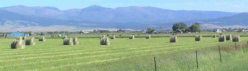
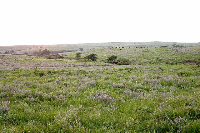
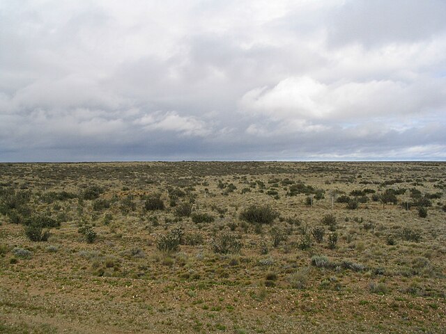
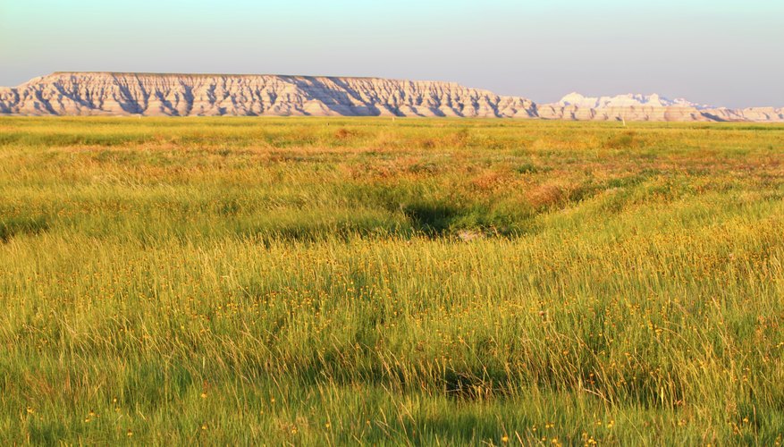
Grass vs Meadow/Pasture vs GrasslandWe still need to address the issue raised in #2433 At the time it was said that: "Mapping practice shows no consistent difference between areas mapped as natural=grassland and landuse=meadow. Locally there are sensible uses of these tags for different purposes but globally it is just a huge mess - quite similar to wood/forest. So the decision was to not make this distinction in rendering." Links to overpass queries around Hamburg, Germany as examples: The PR #1655 merged the color of meadow and grassland. So currently we render all areas of grass the same. Has the mapping situation changed in the past 2 years? Can we consistently distinguish grassland from pasture or meadow? Can we distinguish pasture from landuse=grass or village green? The wiki pages for landuse=grass: "A tag for a smaller areas of mown and managed grass for example in the middle of a roundabout, verges beside a road or in the middle of a dual-carriageway. There are presently many instances of landuse=grass used for any grass - for example patches of grass between tracks in railway corridor - within area tagged with landuse=railway. " So landuse=grass is not necessarily highly managed or mown. Wiki for landuse=meadow: "Used to tag an area of land primarily vegetated by grass plus other non-woody plants, mainly used for hay (meadow) or for grazing animals (pasture)." Note that pasture is tagged the same as meadow. Hay bales in a cut meadow / hay field: Wiki for natural=grassland: "Areas where the vegetation is dominated by grasses (Poaceae) and other herbaceous (non-woody) plants." Note that the original proposal in 2008 has "Areas where the vegetation is dominated by grasses..." but "Natural areas..." was added from 2011. Also, from 2015 to June 2018 the page had this section: _"Idea that wikipedia:Lawns are just "area with managed grass" isn't new. Here is how you can tag it more precisely. It was also noted that decorativeness of the lawns/grass/managed grass is due limited number of species=*. natural=grassland - "area with grass", required This suggests a "natural=grassland" can be managed meadow, pasture or recreational grass? Here are some images from Wikipedia of natural grassland biomes from different parts of the world. There is a large variety in height of the grasses and the presence of shrubs: Grasslands National Park, Saskatchewan Canada (short-grass prairie / steppe) Serengeti savannah, East Africa: Patagonian grasslands (grazed by cattle) Highland semi-desert grassland in Antelope Valley, California |
|
Having said all that, here are some real-world test images with a horizontal dash pattern for grasslands, similar to what was used in the OS map legend. Perhaps this looks better than the vertical dash pattern. There are also some marshes in these images; even though the pattern is similar in shape, the different color is distinct enough, I think. Meadow/pasture are not given a pattern, for contrast (Also, I do not think they should be rendered differently than landuse=grass)
z14 z15 z16 These test areas were mapped by myself based on survey plus aerial imagery; meadow represents land that is transitioning from farmland back to scrub and the scrub is mainly transitional to forest (or sometimes on poor soil), while the "natural" grasslands are rocky hills where the grass is maintained by occasional burning, rather than grazing. Farmland is mainly sweet potato fields, with some rice, taro and other vegetables. EDIT: originally posted to wrong thread, sorry |


|


|
I would have no problem with the same rendering for meadow and grassland, because as they have some differences between each other, thry are also quite similar feature, and we sometimes reuse the same icon/ fill for quite similar objects. @jeisenbe Can you rotate a pattern from #3143 (comment) 90 degree to make it vertical (as plants grow vertically, not horizontally ;) )? I think it could be even set darker (less transparent) to make it more distinguished from landuse=grass. |
|
Do not forget that OSM is not only dedicated to mappers but also to a general public. Creating very accurate distinction between such kind of features does not necessary improve the map but can also create confusion due to the great diversity of colours and patterns. Otherwise, vertical pattern is fine. |
|
@jragusa re: "Creating very accurate distinction between such kind of features does not necessary improve the map but can also create confusion due to the great diversity of colours and patterns." Agreed. If any sort of grass is going to get a pattern, the pattern will need to be subtle and unobtrusive, while also being very intuitive. A tall order! It also should not be easy to confuse with heath, scrub, marsh, bog or other landcover patterns. We'll see if this is possible. @Tomasz-W, you are right that the pattern ended up a little light, because the original icon was a little too thin. It was meant to be a couple percent darker. The pattern is a symbolic representation and maps are flat, so horizontal lines can be a valid representation for grasslands. The Ordinance Survey used such a symbol for rough grass; see the recent comment in #780 showing the patterns used on OS maps in the past: #780 (comment) But here are some tests with the same pattern rotated vertically. Happy birthday! ;-) (Current master for comparison)
But with the pattern there is a risk of confusion. It's good for the patterns to show with overlapping landcovers, so mappers will realize there is a problem in the data that needs correcting. Currently this happens when scrub or forest overlaps another landuse; the green or shrub symbols show up on the other color. But those symbols are fairly easy to recognize and they are distinct from one another. Below I've again shown horizontal dashes for grass and vertical for heath. In this case it is more obvious when the dashes are from different types of grass versus heath overlapping the grass area. 4. Horizontal dash grass, vertical dash heath If heath has a more bushy pattern, it is even easier to distinguish heath from grass: 6. Horizontal grassland, bushy heath I tried a few patterns for grass that use a less abstract icon, but I don't think these work well with the scrub icon; they are a little too big and too detailed: 7. Mix of two representational "grass" icons. (I've also been trying these icons for the heath pattern): 8. Mix of 2 marsh-style icons (similar to those used for current marsh pattern): 9. Marsh-style icon shrunk to 80%: Perhaps we could try a more abstract icon, with 2 to 4 near-vertical lines in one icon like:
I've still not had enough bandwidth to download Inkscape, so I won't be able to make any new svgs for the next couple of weeks. |


|
|
Looking over all of these options, they all seem to make the map too busy, especially since heath would be getting a pattern at the same time. The more subtle patterns are less irritating, but I can't say that I like any of them. Since the goal is to distinguish between landuse=grass and natural=grassland (with landuse=meadow combined with one or the other), we could consider using a subtly different shade of green. There are already too many greens, but if we follow the plan in #3517 to combine golf, campsites and leisure, then we would be able to reuse the current campsite / caravan / picnic site color, #def6c0 This color is close to the current grass color, but a little lighter and less saturated, making it a potential choice for natural=grassland. The change would also have the benefit of making grasslands a little closer in lightness to farmland, and farther from scrub and forest. This gives more room for picking a good heath color. However, it would still be close to the current grass, so it would be subtle difference I might also try all grass in this color, even if we decide not to distinguish landuse=grass from grasslands or meadows, because it works well with the new farmland color. Left grass #cdebb0; middle campsite #def6c0; right new scrub #c8d7ab; Left farmland #eef0d5; middle campsite #def6c0; right park #c8facc; Left Social Amenities ffffe5 , middle campsite #def6c0; right leisure #defce1 ** The grayish background in all the images is land-color (the color of untagged land) Is anyone interested in seeing tests of this idea? (**I think this is the current leisure color; this is the disadvantage of using "lighten 5%"; is that hsla?) |


|
That would be this. For now landuse=grass and natural=grassland are the same and landuse=meadow has the same color as the old camping_site. The golf course, camping and park are still distinguishable because they have different symbols and outlines. For natural=grassland you could make a grass symbol and give it the same color as either grass or meadow. Maybe the meadow can be a tiny shade darker but other then that it seems fine to me. Z18 Z15 Z17, camp_site with new color |


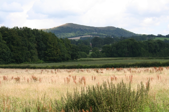
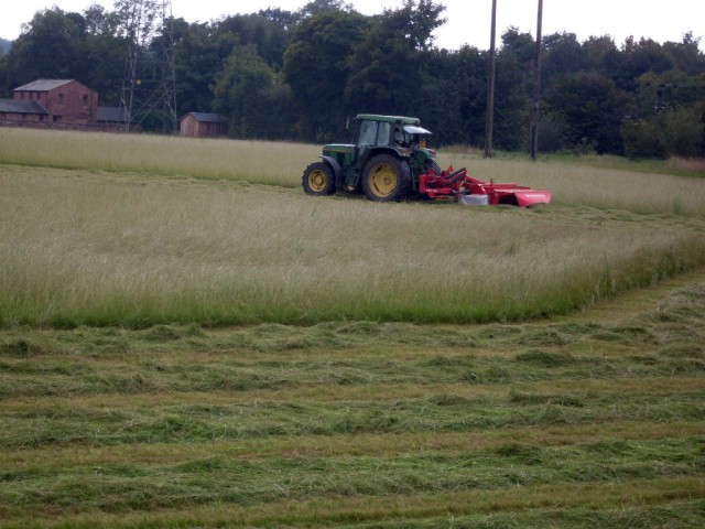
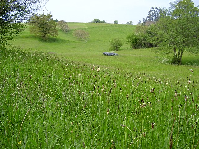
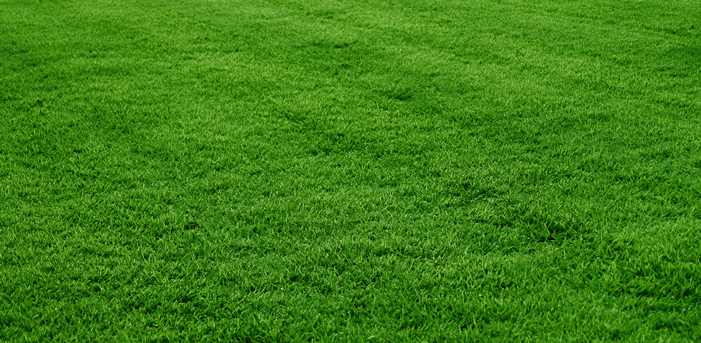
Currently, this (landuse=grass):
is rendered in the same way as this (landuse=meadow):

or this (natural=grassland):
When grass can reach max. 15-20 cm, meadows and grasslands can reach more than 50 cm. I think they are different levels of landcover, so they should be distinguished on map.
For example - you can walk or ride a bike through grass without problem, but is more problematic in a meadow/ grassland, so rendering this features in the same way may be confusing.
My proposition for a start is to use wetland pattern - change it's colour to black, turn 90 degree, and set opacity to 15/25%.
Photoshop mock-up:

The text was updated successfully, but these errors were encountered: