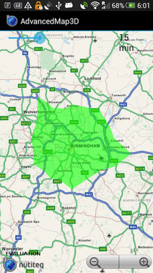
Drive time regions
In some applications you may want to show not route from A to B, but "how far I can get in 15 minutes", or for limited mileage vehicles (hint: electric ones) it could be "will I get to my destination and next charging station remaining fuel". So you want to reduce the range anxiety.
One of the AdvancedMap3D samples - AnimatedLocatonActivity has an easy to use layer DriveTimeRegionLayer, which is essentially an GeoJSON polygon viewer. The polygon is read from online API service which calculates drive range, and there is some UI to enable to enter specific drive range value in minutes.
In this example Nutiteq demo service is used, and this is not for production use. If you need same service for production, please ask Nutiteq (support@nutiteq.com) about it. The demo service uses PgRouting driving_distance() function, and it has OpenStreetMap dataset covering Europe inside. So it works in Europe only, and the requests are not fast enough (a few seconds) for general use. Another great freeware package which has similar function is GraphHopper.