Add DigitalGlobe imagery vintage overlays #371
Comments
|
cc @kevinbullock & @marracci who may be able to answer any questions that people have 👍 |
|
The information is certainly most welcome but having this as a raster layer is technically not ideal. The editors cannot easily interpret this information to for example suggest to the user which image might be outdated. Having this data available as tile metadata like in case of Bing or as a (tiled) vector data set would have many advantages - including better options for zoom independent rendering. Looking over the data in a few places it seems the dates for the premium layer are often of questionable validity (mostly through the there is no way this image was taken at that time of year test). You can also see clear cutlines in the image layer that are not represented in the vintage overlay. |
Yes @imagico - ideally we'll eventually be able to store this in a vector tile layer or something similarly machine readable. Anyway for now, consider it a beta release. 😄 The issue of selecting the best imagery layer in the editor has always been a bit of a hack. We have a "best" flag in the editor-layer-index, but now with Bing, DG Premium, DG Standard, Esri, and Mapbox, and whatever local ortho layers exist, the situation has become a lot more complicated. All of the layers have different strengths and weaknesses. Also worth mentioning, I believe the reported vintage dates only make sense at z13+ where the mosaic kicks in. (lower zooms seem to show a cleaned up Landsat imagery, similar to Mapbox Satellite) For anyone who wants to see what the DigitalGlobe vintage overlay layers look like, you can try it out on the preview iD instance here: http://preview.ideditor.com/master/#background=DigitalGlobe-Standard To toggle the overlays, make sure you have one of the DigitalGlobe layers active, then open the "Background" info panel: Then click "Show Vintage" button in the panel. (This button is only available if you have a DigitalGlobe layer active). Here is another screenshot: |

|
Thanks @imagico for your question/comment and also @bhousel for the follow up on this. We are working to provide a higher-quality vintage overlay for our As @bhousel mentioned, this is still in |
|
Hi @bhousel @imagico - we've updated our vintage display for DigitalGlobe Standard and Premium imagery vintage overlays are best displayed at z13 and larger. This update has been seamlessly published, try it out on the preview iD instance:
Our first version of Original Updated As @bhousel points out, there is a distinct difference between the two DigitalGlobe imagery layers in OSM iD:
|

|
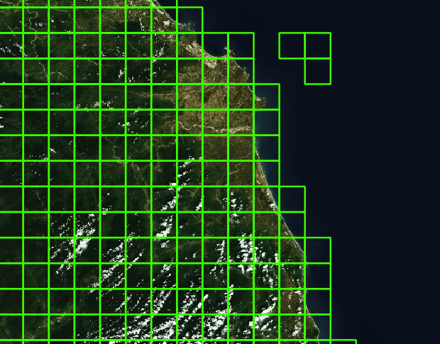
I took a look - the cells you specify the date for are about 7x10km at central European latitudes - which is still fairly coarse for areas with fine grained image combinations. An example: which is specified as 2013-10-25. That is clearly not correct here - a late October image is what you see 10km to the south of that location. I will take a wild guess and say that the date you specify is probably the newest image used in the image assembly process within the cell. 90 percent of the cell might actually show a different image. My assessment is that the cell size would be OK if you specify either the majority date of the cell or the date of the image at the cell center. But with the current logic you would need a much smaller cell size if you want to avoid the date being wrong in the majority of cases in areas like the above. I will take another wild guess and assume that you only have the footprints of the images used and do not have access to the data from the actual assembly process (i.e. which image exactly is used at what location) which would make my suggestion above a bit pointless since you would not know which images are actually used. And smaller cells would not help. But i hope i am wrong about that one... |
DigitalGlobe has put together some raster overlay layers which display the imagery vintage for the DigitalGlobe Premium and DigitalGlobe standard layers. The layers show the boundaries of the imagery sources, and at zooms 14 and above, some text labels showing when the imagery was captured.
Currently this is a "beta", and we're thinking of ways to improve the visibility of the labels at higher zooms. (The labels are sparsely distributed, because they were placed along z11 tile boundaries, so they are easy to miss).
Here's what it looks like:

The text was updated successfully, but these errors were encountered: