DeploymentDatabase
The original Deployment Database (DDB) is an MS-Access database that contains information about all deployments, instruments, personnel and sites for a specific location. Other specific-user databases can be used if a minimum interface requirements are met.
In the toolbox, the DDB/executeDDBQuery function acts as a wrapper around the DDB and returns query results as vectors of Matlab structs. This means that no conversion between Java-Matlab types is necessary.
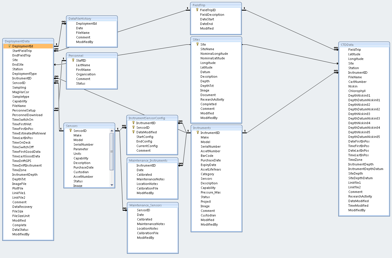
The complete MS-Access DDB schema is shown below:
If one is willing to build its own deployment database, there is a minimum list of requirements to respect to prevent the current version of the imos-toolbox from crashing. The table below provides a list of Fields with "Mandatory" status, i.e. they should always be present.
The following subsection details these requirements:
- All of these tables and fields must be present
- Table and field names must be identical (case sensitive)
- Field types must be identical/compatible
- A few fields may not be mandatory if they are removed from the default NetCDF template (GA -> global attribute in NetCDF\template\global_attributes.txt, VA -> variable attribute in NetCDF\template\variable_attributes.txt)
| Table Name | Field Name | Data Type | Description | Mandatory | NetCDF default template |
|---|---|---|---|---|---|
| FieldTrip | FieldTripID | Text | Field Trip ID - use AIMS Log Req Number | yes | |
| FieldTrip | FieldDescription | Memo | Descriptive text for field trip | yes | |
| FieldTrip | DateStart | Date/Time | Start date for field trip | yes | |
| FieldTrip | DateEnd | Date/Time | End date for field trip | yes | |
| DeploymentData | DeploymentId | Text | Code-generated unique ID | yes | |
| DeploymentData | EndFieldTrip | Text | Field Trip number | yes | |
| DeploymentData | Site | Text | Use to link to sites data table (which contains lat and long) | yes | |
| DeploymentData | InstrumentID | Text | Use to link to Instruments_Id in Instruments table (Instrument description) | yes | |
| DeploymentData | FileName | Text | Catalogue number/Sample number/File name - should ideally be a unique identifier | yes | |
| DeploymentData | TimeSwitchOn | Date/Time | Time instrument is switched on | yes | |
| DeploymentData | TimeFirstWet | Date/Time | Time instrument first in water | yes | |
| DeploymentData | TimeFirstInPos | Date/Time | Time instrumentfirst in position | yes | |
| DeploymentData | TimeLastInPos | Date/Time | Time istrument last in position | yes | |
| DeploymentData | TimeOnDeck | Date/Time | Time instrument on deck | yes | |
| DeploymentData | TimeSwitchOff | Date/Time | Time instrument switched off | yes | |
| DeploymentData | TimeFirstGoodData | Date/Time | Time of first good data | yes | |
| DeploymentData | TimeLastGoodData | Date/Time | Time of last good data | yes | |
| DeploymentData | TimeZone | Text | Time zone eg UTC,CST etc | yes | |
| DeploymentData | InstrumentDepth | Number | Depth of instrument/sample | yes | GA.geospatial_vertical_min, GA.geospatial_vertical_max, VA.sensor_depth |
| DeploymentData | Comment | Memo | Any additional comment to be attached to record | Optional if removed from template, otherwise yes | GA.comment |
| Instruments | InstrumentID | Text | Unique ID for instrument | yes | |
| Instruments | Make | Text | Select existing make from list or add new one | yes | GA.source |
| Instruments | Model | Text | Select existing model from list or add new one | yes | GA.source, GA.keywords |
| InstrumentSensorConfig | InstrumentID | Text | Unique ID for instrument | yes | |
| InstrumentSensorConfig | SensorID | Text | Unique ID for sensor | yes | |
| InstrumentSensorConfig | CurrentConfig | Yes/No | Is this the current Instrument/Sensor configuration | yes | |
| Sensors | SensorID | Text | Unique ID for sensor | yes | |
| Sensors | Parameter | Text | IMOS parameter codes, comma separated, measured by the sensor | yes | |
| Sensors | SerialNumber | Text | Enter serial number for sensor | yes | VA.sensor_serial_number |
| Sites | Site | Text | Unique Site ID | yes | |
| Sites | SiteName | Text | Site Name (Not unique) | yes | |
| Sites | Longitude | Number | Longitude in decimal degrees of Deployment | Optional if removed from template, otherwise mandatory | GA.geospatial_lon_min, GA.geospatial_lon_max |
| Sites | Latitude | Number | Latitude in decimal degrees of Deployment | Optional if removed from template, otherwise mandatory | GA.geospatial_lat_min, GA.geospatial_lat_max |
| Sites | Description | Text | Enter description of site: eg, Scott Reef Lagoon | yes | GA.abstract |
To use CSV files instead of a Microsoft MDB database file, only the above fields are needed. Table Name are individual CSV filenames, Field Name is the respective headers/column names required, and Data type is the expected type for each column. The CSV files need to be consistent among themselves since entries are related as in the image above and should be within the same folder.