Secondary and trunk color too similar to landuse colors #102
Comments
|
Another example of a well camouflaged trunk road: |
|
Highway 1 is the more important road then 97B, but it is much harder to see. I suggest: |

|
Totally agree that this should be fixed! I find it so annoying not being able to easily see a trunk road when it goes through a forest. |
|
I like @mibmib's idea of changing the colors for trunks and secondary roads, but something like that would have to be discussed with the whole community as it would be a major change that would take a bit of getting used to. |
|
OSM is getting more about the whole Earth, than about the roads only. So color scheme should reflect recent state of the map as well the near future. Roads should be concentrated around one, two colors - red/orange or dark blue. |
|
White/yellow/orange/red is much better as blue is typical for water objects (also - it would result in change for trunk and motorways rather than everything except motorways). |
|
See also here: https://trac.openstreetmap.org/ticket/3038 |
|
green. why green? |
|
As far as I understand, the green is inspired by the English Ordnance Survey maps, which use green for trunk roads. The English seem very attached to their colour scheme :). Example: http://www.deddington.org.uk/__data/assets/image/0020/1883/Deddington140000.gif |
|
According to what I found ( http://www.magazine.ordnancesurveyleisure.co.uk/magazine/map-symbols.html ) trunk roads on OS maps are not always green - and in case of using green it is way more saturated. Also, their markings for forests are paler. So maybe more saturated and darker colors for trunk and secondary in OSM would solve this? |
|
I would suggest to solve this by changing (lightening) the landuse color, rather than the road colors. |
|
Making forests paler enough to make trunk roads clearly visible may make problematic to distinguish it from other green areas. |
|
This has not been solved by the recent landuse changes (making farmland lighter). I doubt making the farmland even lighter is possible, so I think secondary on z9-z11 either needs to be made darker, or be given a darker casing. @pnorman can you support that with your brightness calculations? For trunk, I'm not sure what the best solution would be. Maybe @pnorman can confirm i |
|
I think we should make the greens of forests, woods, grass, etc a lot lighter more like how Google maps our something it's done. Then the trunk will bed more visible. |
|
The color used by OSM mapnik is not the optimum for readibility. Trunk (green) on forest is the best (worst) example. Of course OSM Mapnik rendering is not a road centered map, it was more a generic map, but having tertiary more visible than trunk is not a good example to show OSM map. For my part, i think the best solution would be to lighter forest and other green-land and use a different color for trunk. |
|
We have basically two ways to solve this:
If we want to consider the second option, that would obviously require a wider consultation. Do you think this is something worth investigating? |
|
I strongly prefer continental style colour scheme. Ordnance Survey style fails on this map as we are trying to display really wide range of elements - unlike for example http://upload.wikimedia.org/wikipedia/commons/c/c8/Ordnance_Survey_1-250000_-_TF.jpg http://www.openstreetmap.org/#map=12/52.7633/0.3687 Note difference in details (scale is roughly the same).
|

|
Mapquest Open uses continental style in continental Europe, and an OS-like style in the UK. Their continental style works really well, I would say. |
|
I prefer the second option. Definitely should be investigated further. -- Matthew Buchanan On Thu, Oct 30, 2014 at 11:40 AM, math1985 notifications@github.com wrote:
|
I wouldn't say so. tertiary and residential streets are displayed the same, on high zoom levels even also secondarys. This is maybe by design but would't work well for mapnik. Regarding trunks: on low zoom the primaries are barely to see, so the trunks (and also motorways) look like unconnected parts. Example: http://osm.org/go/0JfpA1--?layers=Q&m= I would only change the color of trunks in mapnik from green to some kind of red or purple. |
MapQuest Open also uses Mapnik. |
Currently the casing helps a lot at z>=12, it might be a good idea to use a somewhat different color at low zooms than the fill color at high zooms. Farmland paler would in principle work for me but it would immediately collide with the bare ground base color.
in this style. |
Certainly in this style at least. Boundaries are all purple, and so are hangars. In any case, pedestrian streets are usually shown muted in OSM styles. Streets are only highlighted with color when they're more significant than unclassified. The purple makes the pedestrian street look similarly important. |
In proposed style fill on low zoom levels is the same color as casing on high (fill on high is paler). Low zoom levels have no casing, maybe adding it would be a good idea...
The intention was mainly to make it clearly different. Many styles show highway=pedestrian like highway=footway but I am not really happy about it. |
|
I don't think casing would do any good at z<12. But the colors that work good for the casing at high zooms probably are not equally suited for the full line at low zooms - for that purpose i'd probably try it somewhat less saturated and if necessary to be well visible darker. By the way - have you considered doing something about the dominance of minor roads in urban areas and the noise resulting from it at z=10/11? |
Yes, see comparison in https://www.openstreetmap.org/user/Mateusz%20Konieczny/diary/34957 For now z16 is ready, but I also tested this issue to ensure that selected colors for major road will be visible on lower zoom levels. Ensuring that minor roads will not be too visible is planned. Maybe a separate issue should be opened for that, probably I will do this once there will be before/after image to post. |
I think that there is still plenty of space for making it paler - see http://www.openstreetmap.org/#map=11/52.0111/-1.5003. landuse=farmland dominates nearly everything else (maybe except road shields). |
|
2015-07-03 19:15 GMT+02:00 Mateusz Konieczny notifications@github.com:
because it is bad mapping style ;-) Basically they started asserting |
|
Sorry for being ambiguous - with 'bare ground base color' i meant @bare_ground (#eee5dc), not @land-color (#f2efe9). |
I have two versions - one with black labels, one with red ones. Red one is my preferred version. https://cloud.githubusercontent.com/assets/899988/8511593/9858fcd4-231f-11e5-84e8-63266da45217.png |
|
Just wanted to say that this already looks like a great improvement, I'm looking forward to the proposal. |
|
@nebulon42 +1 👍 |
|
The red motorway junctions looks better than the black. |
|
Seeing that i realize changing the label color is not as easy as i thought. Black labels are confusing since there are a lot of black labels for other stuff and likewise there are quite a few brownish/reddish label types. Blue is also used for railway stations etc. so it is not necessarily a bad idea to use it for all travel/transport structure related labels. And the oneway arrows seem much better in blue as well. |
|
About motorway equaling trunk: (edit: fix link) |
|
I agree with jojo4u. The standard carto rendering is as much a debugging tool as a navigation tool. Harder to spot mapping errors if you have to load the data in an editor instead of just looking at the map. |
|
Colors: I find the secondary "honey yellow" quite unusual, I cannot "look away" from it. It has quite the same prominence as motorway,trunk,primary. Also the very pale yellow of tertiary is a bit confusing: I always look twice at tertiary vs. residential since the difference is so slight. |
|
@jojo4u "So what does the map display? Importance or quality of travel?" From the debate about unsealed roads (#110), I think the map displays importance more prominently, and is going to add subtle hints about quality of travel in some (perhaps very specific) situations. I would say that rendering styles of tracks for grade1 to grade5 also follow that idea. It seems to me that "motorway" is always both important and high quality, whereas "trunk" is always important but quality varies (sometimes as good as motorway, sometimes much less, it mostly depends on which country one is talking about). Motorways and trunks are probably not equally important on average, but sometimes trunks can be as important as other motorways. To me, this suggests they should be rendered similar (for instance, more similar than primary and secondary are to each other), but not exactly the same as motorways. |
|
sent from a phone
I believe a clear distinction between rail and road related features is desirable |
|
Trunks and Motorways are currently very different in how things are mapped in the UK. Primary and secondary are more similar so if you were looking at which roads to render in a similar way then those would be prime candidates for me. See for example the mapsurfer.net style on openstreetmap.ru |
|
@matkoniecz Have you seen the new OsmAnd online rendering? I"m not sure if I sent it to you before. Left is our rendering, right is OsmAnd (it is no longer 'old Mapnik', ignore the caption). |
|
@matkoniecz That's a good start! I know too much feedback can be overwhelming, but would it be possible to produce some side-by-side examples so we have some comparison of different options? I think living_street and pedestrian look much better in the new rendering. I agree with the points on mapper-feedback loop, and I think all highway types should be distinct at at least some zoomlevel. Have you tried a German-like style with a thick casing for trunk/primary? I also agree the tertiary colour in the proposed rendering does not work very well. |
|
Agree with all, this is already great! Thank you @matkoniecz ! I see the difficulty in rendering the extra road classes that OSM uses, compared to other maps that have one or two classes less. But I agree with the "Mappers Loop" argument, so +1 for making trunk and motorway a bit different again. Maybe a darker red for motorway is good? An idea I got from looking at Google's maps: could we use line width to differentiate streets more often? Maybe tertiary and unclassified / residential could all be white with grey casing, but tertiary is wider? |
|
I think these look too similar. It is really hard to tell the difference between the road classifications. I have no idea, for example, which is the best/major roads to get around a city. The reasoning behind combining the motorway/trunk is confusing and I am unclear what you are trying to acheive. We have a clear heiracarcy of roads and although in OSM some countries standards my combine them, others do not. We should stick to a overall heiracarcy and they should be notably distinct. Also if there are clashes with existing items when adding new rendering but there are always at least 2 ways of solving this by fixing either feature. I still think we need to fix the greens first. |
Since this comment rendering changed a bit, especially on z12. #1387 (comment) has preview of latest version on the dark backround (forest). Outlining is still quite weak - is it still a problem after changes?
Yes, that would be a problem. And making @bare_ground would probably make necessary to change also something else... @math1985
I was unaware about it, thanks! BTW, is there now a place to compare current style with the old mapnik? @math1985
I posted some in the diary entry ( http://www.openstreetmap.org/user/Mateusz%20Konieczny/diary/35351 ) and the next week I will post next batch. Are you interested in some specific location/variation? @math1985 @everybody
I reverted tertiary colour to one before changes - and it seems that everybody prefers it this way.
I will add some way to differentiate motorway and trunk. @math1985
Is trunk/primary instead of trunk/motorway intentional?
I will try this a bit more (doing this for living_street vs residential failed, but it may fit better to driveway-service-residential-tertiary progression).
I tweaked colour and increased difference between primary and trunk/motorway. See #1387 (comment) for an example of latest rendering. I will work in next days on differentiating motorway/trunk. |
|
z12 looks much better now. The casing color for tertiary still looks too saturated to me - thin lines like with this kind of casing usually work better if they are less saturated. IIRC you said you use the same color for casing and for the lines at low zooms - but you don't really need to. The red might be somewhat strong at the very low zooms (<=6) - but this is something that will be difficult to judge without the full view of course. |
Thanks for this idea, it turned out to work well (see one of examples in http://www.openstreetmap.org/user/Mateusz%20Konieczny/diary/35437 ). |
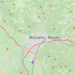
Secondary and trunk are rendered with a color that is way too similar to landuse=forest/meadow/farmland. Makes it quite difficult to see them at lower zooms.
One solution is to make landuse less saturated and even more pale. This would have the added benefit of making the difference between the basemap color and landuse less distinct which, IMHO, equals a prettier map.
Spot the secondaries and trunks. ;)
The text was updated successfully, but these errors were encountered: