Skip to content
New issue

Have a question about this project? Sign up for a free GitHub account to open an issue and contact its maintainers and the community.

By clicking “Sign up for GitHub”, you agree to our terms of service and privacy statement. We’ll occasionally send you account related emails.

Already on GitHub? Sign in to your account

Show coordinated as grid codes #18119

Closed
qgib opened this issue Feb 10, 2014 · 8 comments
Closed

Show coordinated as grid codes #18119

qgib opened this issue Feb 10, 2014 · 8 comments
Labels
Feature Request GUI/UX Related to QGIS application GUI or User Experience

Comments

@qgib
Copy link
Contributor

qgib commented Feb 10, 2014

Author Name: Geoff Owen (@go)
Original Redmine Issue: 9530

Redmine category:gui


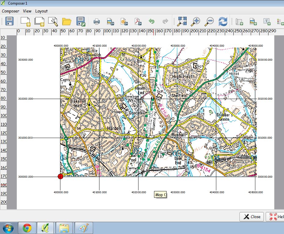
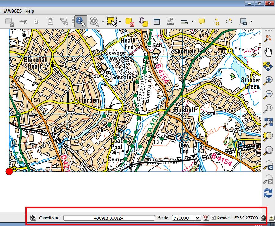
I create all my projects and add new layers using the 'EPSG:27700 OSGB 1936 British National Grid CRS'.
This currently gives numeric values which although not a problem would be nice if one could display it in alpha numeric format.


@qgib
Copy link
Contributor Author

qgib commented Feb 11, 2014

Author Name: Leyan Ouyang (Leyan Ouyang)


What do you mean by alphanumeric format? Can you give an example of what you want to display?

@qgib
Copy link
Contributor Author

qgib commented Feb 12, 2014

Author Name: Geoff Owen (@go)


Hello Leyan.
Thanks for query.
I will try to explain what I want to display but first will need to explain how the grid reference system (British National Grid) for Great Britain works.
Please refer to attached pic.
Here we go.
1 Great Britain is divided into a series of 100KM X 100KM grid squares.
2 Each square has a 2 digit number and pair of letters.
3 For example :- Grid square SJ is numbered 33.
4 Lets imagine you want to quote a grid reference for the southwest corner of grid square SJ.
5 This can be quoted 2 ways :- SJ 000,000 OR 3000,3000.
6 The same applies to any other grid square.
7 For example, the southwest corner of grid square SP could be quoted as SP 000,000 OR
4000,2000.
Currently QGIS will only display co ordinates in numeric format but it would be nice to have the option for displaying alpha numeric format.
Hope this makes sense.
If not I will try again.
Regards
Geoff


  • 6782 was configured as British_National_Grid.jpg

@qgib
Copy link
Contributor Author

qgib commented Feb 13, 2014

Author Name: Giovanni Manghi (@gioman)


Geoff Owen wrote:

Hello Leyan.
Thanks for query.
I will try to explain what I want to display but first will need to explain how the grid reference system (British National Grid) for Great Britain works.
Please refer to attached pic.
Here we go.
1 Great Britain is divided into a series of 100KM X 100KM grid squares.
2 Each square has a 2 digit number and pair of letters.
3 For example :- Grid square SJ is numbered 33.
4 Lets imagine you want to quote a grid reference for the southwest corner of grid square SJ.
5 This can be quoted 2 ways :- SJ 000,000 OR 3000,3000.
6 The same applies to any other grid square.
7 For example, the southwest corner of grid square SP could be quoted as SP 000,000 OR
4000,2000.
Currently QGIS will only display co ordinates in numeric format but it would be nice to have the option for displaying alpha numeric format.
Hope this makes sense.
If not I will try again.
Regards
Geoff

Where those "coordinates" should appear, in the layout composer? in the canvas?


  • os_version was changed from XP and higher to
  • status_id was changed from Open to Feedback
  • operating_system was changed from Windows to

@qgib
Copy link
Contributor Author

qgib commented Feb 14, 2014

Author Name: Geoff Owen (@go)


Hello
Coordinates appear in canvas view at bottom of screen.(Please see attached screen shot 1).
Coordinates also appear in composer if I add a grid. (Please see attached screen shot 2).
On both attached pics, coordinates for the red marker is located at '400913, 300124'.
Taking the first digit of each coordinate gives the number 43.
Number 43 is grid square 'SK' when using the British National Grid.
So using the British National Grid, coordinates for the red marker could also be quoted as
'SK 00913, 00124'.
Hope this makes sense.
Regards
Geoff


  • 6796 was configured as 2_Map_Composer.jpg
  • 6795 was configured as 1_Map_Canvas.jpg

@qgib
Copy link
Contributor Author

qgib commented Feb 15, 2014

Author Name: Giovanni Manghi (@gioman)


Geoff Owen wrote:

Hello
Coordinates appear in canvas view at bottom of screen.(Please see attached screen shot 1).
Coordinates also appear in composer if I add a grid. (Please see attached screen shot 2).
On both attached pics, coordinates for the red marker is located at '400913, 300124'.
Taking the first digit of each coordinate gives the number 43.
Number 43 is grid square 'SK' when using the British National Grid.
So using the British National Grid, coordinates for the red marker could also be quoted as
'SK 00913, 00124'.
Hope this makes sense.
Regards
Geoff

while it seems it can be useful for a specific use case, it don't don't know if/how this can be generalized in order to work for any user. This functionality seems best fitted for a plugin, don't you think?


  • subject was changed from Co Ordinate Reference System to Show coordinated as grid codes
  • fixed_version_id was changed from Future Release - Nice to have to Future Release - Lower Priority

@qgib
Copy link
Contributor Author

qgib commented Feb 15, 2014

Author Name: Geoff Owen (@go)


Hello Giovanni.
Thanks for getting involved.
I think my suggestion would be useful but only for a very few users.
Must agree with you that perhaps a plug in would be the best solution.
I know nothing about writing plug ins but maybe this would be a good chance to attempt writing my first plug in.
Many Thanks
Geoff

@qgib
Copy link
Contributor Author

qgib commented Feb 16, 2014

Author Name: Giovanni Manghi (@gioman)


Geoff Owen wrote:

Hello Giovanni.
Thanks for getting involved.
I think my suggestion would be useful but only for a very few users.
Must agree with you that perhaps a plug in would be the best solution.
I know nothing about writing plug ins but maybe this would be a good chance to attempt writing my first plug in.

so don't get me wrong if I close this ticket. Maybe I'm missing some point on how this suggestion can be useful for any Q(GIS) user and eventually a developer will reopen this. Meanwhile if you need you can ask for help about the plugin in the users/developers mailing list or contact one of the many companies that offer commercial support http://qgis.org/de/site/forusers/commercial_support.html

cheers!


  • resolution was changed from to wontfix
  • status_id was changed from Feedback to Closed

@qgib
Copy link
Contributor Author

qgib commented Feb 16, 2014

Author Name: Geoff Owen (@go)


Giovanni
Thanks for your interest in this.
No bother you closing this ticket.
Plenty more QGIS stuff for you to get involved with.
Thanks for the suggestions.
Maybe I will be able to write my first plug in.
Many Regards
Geoff

@qgib qgib added Feature Request GUI/UX Related to QGIS application GUI or User Experience labels May 24, 2019
@qgib qgib added this to the Future Release - Lower Priority milestone May 24, 2019
@qgib qgib closed this as completed May 24, 2019
Sign up for free to join this conversation on GitHub. Already have an account? Sign in to comment
Labels
Feature Request GUI/UX Related to QGIS application GUI or User Experience
Projects
None yet
Development

No branches or pull requests

1 participant