Specific virtual layers definitions make the load of a project fail completely #24831
Comments
|
Author Name: Giovanni Manghi (@gioman) can you give more datails? are the shapes in a local disk? a network one? what the QGIS logs show? it happens always for the same projects or just at time? have you tried by starting QGIS in a clean environment, especially useful is to try disable/remove all 3rd party plugins.
|
|
Author Name: Lee Han (Lee Han) shapes are on network or on local disk. It happens on different projects. I have uninstalled plugins except those natives (georeferencer, processing,...). No effect. the only thing remaining is the name of a group. what log would you like to read ? |
|
Author Name: Giovanni Manghi (@gioman) Lee Han wrote:
settings > panel > log |
|
Author Name: Lee Han (Lee Han) I know the log panel :).
|
|
Author Name: Giovanni Manghi (@gioman) Lee Han wrote:
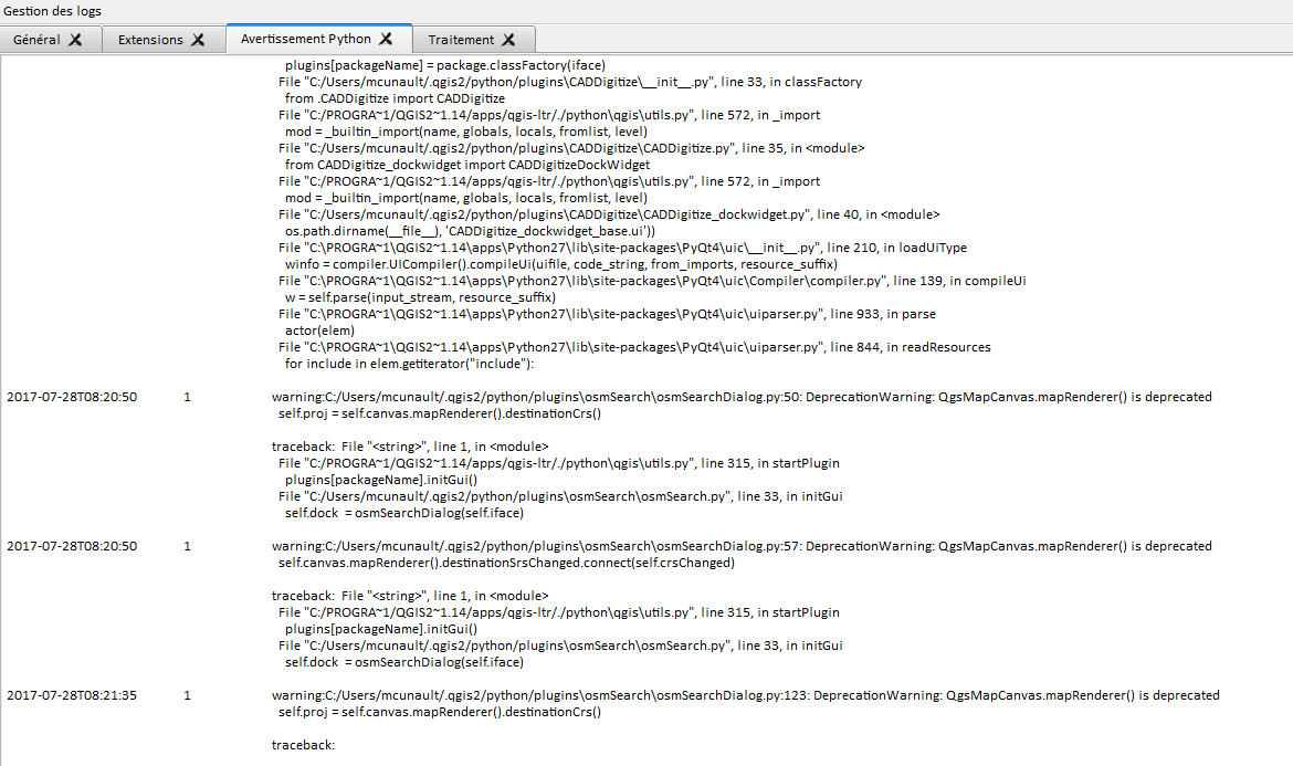
copy/pasting the content of logs it would be better, anyway from the "python.png" image is possible to see that you have still 3d party plugins enabled/installed. Please try by (backing up and) removing the .qgis2 folder, then restart qgis. If does not work please also try to understand if it is something that happens only in your computer or also in others. |
|
Author Name: Lee Han (Lee Han) removing folder .qgis2 has no effet : project still empty. I have tried on another computer with same files and project : same result, project empty. Would you like me to send datas and project ? |
|
Author Name: Giovanni Manghi (@gioman)
yes thanks. |
|
Author Name: Lee Han (Lee Han) done.
|
|
Author Name: Giovanni Manghi (@gioman) Lee Han wrote:
the problem is definitely in one of the query layers in the project, I removed a few of them manually and the project started to load correctly. Please try isolate the offending one(s) (tags <maplayer ...> ... ) and let us know, there seems to be something wrong here. |
|
Author Name: Lee Han (Lee Han) Indeed, two virtual layers are guilty ! |
|
Author Name: Giovanni Manghi (@gioman)
In the attached file there is a project (F119849_plan.qgs) that when loaded in QGIS it loads completely empty, despite the layers definitions are ok (and the data available). It turns that there are two query layers (created within QGIS) that if removed will "fix" the problem > the rest of the layers in the project (included other query layers) are loaded normally. The two offending layers are fossé_emprise the definition of the first (as example) is: @ Old description: |
|
Author Name: Giovanni Manghi (@gioman)
In the attached file there is a project (F119849_plan.qgs) that when loaded in QGIS it loads completely empty, despite the layers definitions are ok (and the data available). It turns that there are two query layers (created within QGIS) that if removed will "fix" the problem > the rest of the layers in the project (included other query layers) are loaded normally. The two offending layers are fossé_emprise the definition of the first (as example) is: @ Old description: In the attached file there is a project (F119849_plan.qgs) that when loaded in QGIS it loads completely empty, despite the layers definitions are ok (and the data available). It turns that there are two query layers (created within QGIS) that if removed will "fix" the problem > the rest of the layers in the project (included other query layers) are loaded normally. The two offending layers are fossé_emprise the definition of the first (as example) is: 1523346.35480000078678131 6238508.21950000151991844 1523567.49449999630451202 6238690.22529999911785126 fossé_emprise220170725120837237 ?query=select%20f.num,%20st_union(geometry)%20as%20geom%20from%20%22foss%C3%A9_emprise%22%20f%0D%0Agroup%20by%20num fossé_emprise2 +proj=lcc +lat_1=46.25 +lat_2=47.75 +lat_0=47 +lon_0=3 +x_0=1700000 +y_0=6200000 +ellps=GRS80 +towgs84=0,0,0,0,0,0,0 +units=m +no_defs 1766 3947 EPSG:3947 RGF93 / CC47 lcc GRS80 false virtual COALESCE( "num", '<NULL>' ) 0 0 0 num 0 0 0 generatedlayoutOld description: |
|
Author Name: Giovanni Manghi (@gioman) End of life notice: QGIS 2.18 LTR Source: QGIS 3.4 has recently become our new Long Term Release (LTR) version. This is a major step in our history – a long term release version based on the massive updates, library upgrades and improvements that we carried out in the course of the 2.x to 3x upgrade cycle. We strongly encourage all users who are currently using QGIS 2.18 LTR as their preferred QGIS release to migrate to QGIS 3.4. This new LTR version will receive regular bugfixes for at least one year. It also includes hundreds of new functions, usability improvements, bugfixes, and other goodies. See the relevant changelogs for a good sampling of all the new features that have gone into version 3.4 Most plugins have been either migrated or incorporated into the core QGIS code base. We strongly discourage the continued use of QGIS 2.18 LTR as it is now officially unsupported, which means we’ll not provide any bug fix releases for it. You should also note that we intend to close all bug tickets referring to the now obsolete LTR version. Original reporters will receive a notification of the ticket closure and are encouraged to check whether the issue persists in the new LTR, in which case they should reopen the ticket. If you would like to better understand the QGIS release roadmap, check out our roadmap page! It outlines the schedule for upcoming releases and will help you plan your deployment of QGIS into an operational environment. The development of QGIS 3.4 LTR has been made possible by the work of hundreds of volunteers, by the investments of companies, professionals, and administrations, and by continuous donations and financial support from many of you. We sincerely thank you all and encourage you to collaborate and support the project even more, for the long term improvement and sustainability of the QGIS project.
|
Author Name: Lee Han (Lee Han)
Original Redmine Issue: 16932
Affected QGIS version: 2.18.11
Redmine category:project_loading/saving
New description:
In the attached file there is a project (F119849_plan.qgs) that when loaded in QGIS it loads completely empty, despite the layers definitions are ok (and the data available). It turns that there are two query layers (created within QGIS) that if removed will "fix" the problem > the rest of the layers in the project (included other query layers) are loaded normally.
The two offending layers are
fossé_emprise
fossé_emprise2
the definition of the first (as example) is:
1523346.35480000078678131 6238508.21950000151991844 1523567.49449999630451202 6238690.22529999911785126 fossé_emprise220170725120837237 ?query=select%20f.num,%20st_union(geometry)%20as%20geom%20from%20%22foss%C3%A9_emprise%22%20f%0D%0Agroup%20by%20num fossé_emprise2 +proj=lcc +lat_1=46.25 +lat_2=47.75 +lat_0=47 +lon_0=3 +x_0=1700000 +y_0=6200000 +ellps=GRS80 +towgs84=0,0,0,0,0,0,0 +units=m +no_defs 1766 3947 EPSG:3947 RGF93 / CC47 lcc GRS80 false virtual COALESCE( "num", '<NULL>' ) 0 0 0 num 0 0 0 generatedlayoutOld description:
I encounter the problem more and more often and it begins seriously to become embarrassing : I open a project of yesterday and it is empty or I just have the title groups, groups emptied of their layers. And the layers of the project are shp and virtual layers resulting from queries.
The .qgs has hundreds of kilos and when I edit it, I find my layers in the tags, the paths are good, I have no messages like what tags are badly closed and file is not truncated. Is project finally lost ? Is there a way to get my projects back ?
Thanks
The text was updated successfully, but these errors were encountered: