XYZ Tile Server with custom CRS not working #26705
Comments
|
Author Name: Bruce Steedman (Bruce Steedman) Related to #26713 re incorrect crs parsed from ESRI wkt on server. Also, problem still exists in QGIS v3.02 on Ubuntu 18.04 LTS. |
|
Author Name: Jürgen Fischer (@jef-n) Please test with QGIS 3.4 - QGIS 2.18 reached it's end of life.
|
|
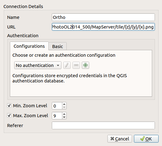
Author Name: Bruce Steedman (Bruce Steedman) Thanks for looking at this Jürgen. Just tried with 3.4.4 and the same result. Exactly the same steps as before & this time I set the zoom range to 0 to 9, as per the MapServer (see attached image): http://dcw7.digimap.je/arcgis/rest/services/StatesOfJersey/JerseyAerialPhotoOL2014_500/MapServer (note custom zoom level with 0 being 1:250,000) However, when I look at the network requests QGIS is making I see requests like this: GET http://dcw7.digimap.je/arcgis/rest/services/StatesOfJersey/JerseyAerialPhotoOL2014_500/MapServer/tile/15/16336/16425.png - i.e. a zoom level outside of the 0-9 range. Question: Can QGIS XYZ tile layers deal with custom zoom levels like this and/or is perhaps the root of the problem that the correct CRS (EPSG:3109) is not being read/converted from the MapServer WKT under the 'Spatial Reference' key? Many thanks Bruce
|
|
Author Name: Jürgen Fischer (@jef-n)
|
|
This is still valid on QGIS 3.16.15 and 3.22.2. |
|
Is this still valid issue? |
|
The QGIS project highly values your report and would love to see it addressed. However, this issue has been left in feedback mode for the last 14 days and is being automatically marked as "stale". |
|
While we hate to see this happen, this issue has been automatically closed because it has not had any activity in the last 42 days despite being marked as feedback. If this issue should be reconsidered, please follow the guidelines in the previous comment and reopen this issue. |
Author Name: Bruce Steedman (Bruce Steedman)
Original Redmine Issue: 18873
Affected QGIS version: 3.4.4
Redmine category:web_services_clients/xyz
I have added the following URL pattern as an XYZ Tile Server connection:
http://dcw7.digimap.je/arcgis/rest/services/StatesOfJersey/JerseyAerialPhotoOL2014_500/MapServer/tile/{z}/{y}/{x}.png
An example tile is at http://dcw7.digimap.je/arcgis/rest/services/StatesOfJersey/JerseyAerialPhotoOL2014_500/MapServer/tile/0/268/331
When I add the layer no tiles are rendered on my map.
I have successfully added other tile layers, which work: e.g. https://server.arcgisonline.com/ArcGIS/rest/services/World_Topo_Map/MapServer/tile/{z}/{y}/{x}.png
The Map Server I am trying to add uses a custom CRS: EPSG:3109 (which uses a custom map origin). I have this CRS set in my project and on the fly projection enabled.
When added, the layer does not pick up the custom CRS, but instead uses EPSG:3857. Changing to the correct CRS in the added layer does not resolve the problem.
I note that the Server specifies 9 zoom levels, with 0 scaled at 1:250,000.
Does 2.18 LTS support Tile Servers with custom CRS & scales and if not does QGIS 3 do so?
Steps to reproduce above and no known workaround.
Many thanks.
The text was updated successfully, but these errors were encountered: