This Python script analyzes the terrain of Mars and estimates the optimum landing places for Mars rovers using Standard Deviation and Peak-to-Valley data. The analysis is done using the MOLA (Mars Orbiter Laser Altimeter) map, which depicts the geographical heights of Mars, allowing us to locate the best landing sites for the Rover on Mars.
MOLA (Mars Orbiter Laser Altimeter) is a map that depicts the geographical heights of Mars using laser altimeter data. The MOLA map offers accurate altitude information and allows us to locate the best landing sites for Mars rovers. It was created by the Mars Global Surveyor MOLA and MOC teams and is made up of 200 million MOLA laser altimeter data plus 1,000 MOC wide-angle photographs.
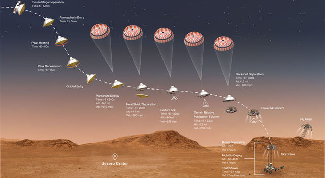
To successfully land a spacecraft on Mars, we send it into space with hundreds of thousands of lines of code, providing instructions for each of the maneuvers it will need to perform to land safely. This includes measuring the distance from the surface, knowing when to perform each maneuver, communicating its status with mission controllers on Earth, and safely beginning operations upon reaching the surface.
To use the Mars Rover Landing Site Selector, simply run the Python script and provide the necessary inputs when prompted. The script will then analyze the MOLA map and provide the optimum landing sites for Mars rovers based on Standard Deviation and Peak-to-Valley data.
This script was created using data extracted from the NASA website (https://attic.gsfc.nasa.gov/mola/images.html).