You signed in with another tab or window. Reload to refresh your session.You signed out in another tab or window. Reload to refresh your session.You switched accounts on another tab or window. Reload to refresh your session.Dismiss alert
Hi! First, thanks for making this package available :)
I'm trying to make the package work with a custom turtle-bot based robot, and I'm trying to figure out where is the missing piece to make the package work.
The turtlesim3_waffle_demo.launch worked normally, but with my particular configuration, the map is only outputting nan values, and I cannot see any error in the console even in DEBUG mode.
What could this problem be? I'm using a Kinect sensor.
Thanks!
[ INFO] [1581555088.648572068]: Elevation mapping node started.
[ INFO] [1581555088.690070893]: Elevation map grid resized to 50 rows and 50 columns.
[ INFO] [1581555088.773560937]: Elevation mapping node initializing ...
[ INFO] [1581555089.872467718, 1061.134000000]: Done initializing.
[ INFO] [1581555089.880065807, 1061.138000000]: First corresponding point cloud and pose found, elevation mapping started.
[DEBUG] [1581555089.894130976, 1061.154000000]: ElevationMap received a point cloud (307200 points) for elevation mapping.
[DEBUG] [1581555089.894198556, 1061.154000000]: Elevation map is checked for relocalization.
[DEBUG] [1581555089.894462649, 1061.154000000]: Elevation map has been moved to position (-6.240000, -0.160000).
[DEBUG] [1581555089.894487675, 1061.154000000]: Updating map with latest prediction from time 0.000000.
[ERROR] [1581555089.894507424, 1061.154000000]: Could not get pose information from robot for time 1061.083000. Buffer empty?
[ERROR] [1581555089.894524581, 1061.154000000]: Updating process noise failed.
[DEBUG] [1581555089.937094472, 1061.196000000]: ElevationMap received a point cloud (307200 points) for elevation mapping.
[DEBUG] [1581555089.937280483, 1061.196000000]: Elevation map is checked for relocalization.
[DEBUG] [1581555089.937375384, 1061.196000000]: Updating map with latest prediction from time 1061.160000.
[DEBUG] [1581555089.945017191, 1061.204000000]: Point cloud transformed to frame camera_depth_optical_frame for time stamp 1061132000.000000.
[DEBUG] [1581555089.951781006, 1061.211000000]: cleanPointCloud() reduced point cloud to 115740 points.
[DEBUG] [1581555089.955785833, 1061.215000000]: Limiting point cloud to the height interval of [-inf, 0.400000] relative to the robot base.
[DEBUG] [1581555089.961000827, 1061.220000000]: removePointsOutsideLimits() reduced point cloud to 84178 points.
[DEBUG] [1581555090.116506230, 1061.369000000]: Raw map has been updated with a new point cloud in 0.115524 s.
[DEBUG] [1581555090.126854044, 1061.377000000]: ElevationMap received a point cloud (307200 points) for elevation mapping.
[DEBUG] [1581555090.127061399, 1061.377000000]: Elevation map is checked for relocalization.
[DEBUG] [1581555090.127213671, 1061.377000000]: Updating map with latest prediction from time 1061.160000.
[DEBUG] [1581555090.146006097, 1061.394000000]: Limiting point cloud to the height interval of [-inf, 0.400000] relative to the robot base.
[DEBUG] [1581555090.148020359, 1061.395000000]: removePointsOutsideLimits() reduced point cloud to 84178 points.
[DEBUG] [1581555090.280338873, 1061.517000000]: Raw map has been updated with a new point cloud in 0.098854 s.
[DEBUG] [1581555090.287962711, 1061.524000000]: ElevationMap received a point cloud (307200 points) for elevation mapping.
[DEBUG] [1581555090.288007030, 1061.524000000]: Elevation map is checked for relocalization.
[DEBUG] [1581555090.288051888, 1061.524000000]: Updating map with latest prediction from time 1061.461000.
[DEBUG] [1581555090.306167399, 1061.535000000]: Limiting point cloud to the height interval of [-inf, 0.400000] relative to the robot base.
[DEBUG] [1581555090.308592203, 1061.537000000]: removePointsOutsideLimits() reduced point cloud to 84178 points.
^C[DEBUG] [1581555090.438599661, 1061.657000000]: Raw map has been updated with a new point cloud in 0.098192 s.
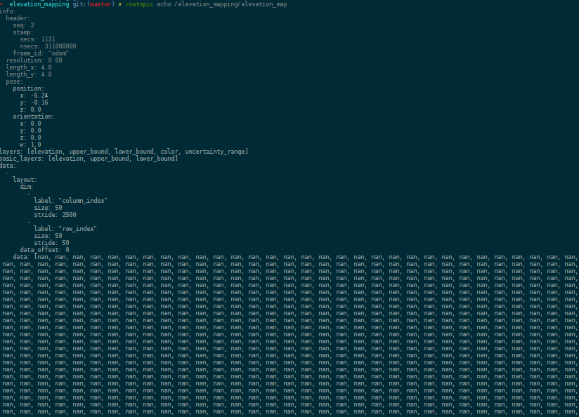
When echoing the contents of /elevation_mapping/elevation_map I'm seeing the layers full of nan like in the attached picture:
The text was updated successfully, but these errors were encountered:
could you run your setup with DEBUG messages to see if elevation mapping adds points from the point cloud?
Can you also plot the pose values? Some points of the point cloud get filtered out of the elevation map because of the following messages:
[DEBUG] [1581555090.146006097, 1061.394000000]: Limiting point cloud to the height interval of [-inf, 0.400000] relative to the robot base.
[DEBUG] [1581555090.148020359, 1061.395000000]: removePointsOutsideLimits() reduced point cloud to 84178 points.
It could be that only points remain that are outside of the defined elevation map area.
Hi! First, thanks for making this package available :)
I'm trying to make the package work with a custom turtle-bot based robot, and I'm trying to figure out where is the missing piece to make the package work.
The turtlesim3_waffle_demo.launch worked normally, but with my particular configuration, the map is only outputting nan values, and I cannot see any error in the console even in DEBUG mode.
What could this problem be? I'm using a Kinect sensor.
Thanks!
My YAML config (myrobot.yaml) looks like this:
The transformation between the camera frame and the robot exists:
The pose with covariance is given by the odom + IMU with the robot_pose_ekf package:
My launch file looks like this:
And the output with DEBUG flags looks like this:
When echoing the contents of

/elevation_mapping/elevation_mapI'm seeing the layers full of nan like in the attached picture:The text was updated successfully, but these errors were encountered: