Skip to content
New issue

Have a question about this project? Sign up for a free GitHub account to open an issue and contact its maintainers and the community.

By clicking “Sign up for GitHub”, you agree to our terms of service and privacy statement. We’ll occasionally send you account related emails.

Already on GitHub? Sign in to your account

Street complete seems to show railway information in the wrong location #1527

Closed
joostschouppe opened this issue Aug 20, 2019 · 7 comments · Fixed by streetcomplete/streetcomplete-mapstyle#71
Labels

Comments

@joostschouppe
Copy link

StreetComplete shows the main Liège railway station in a completely wrong location. Reported by a user, and visble in my Android with version 13.
For more info see https://www.openstreetmap.org/note/1891186

@westnordost
Copy link
Member

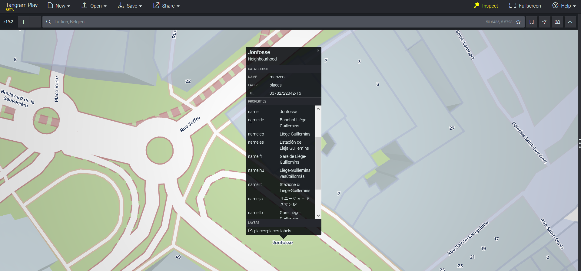
This is how the place looks like in StreetComplete. Anything wrong with it?

https://map-data.de/#map=18/50.64333/5.5725835&style=streetcomplete-light

@joostschouppe
Copy link
Author

joostschouppe commented Aug 20, 2019

Uh, this is weird.
In your link:

  • it looks right in the cinnabar style
  • the streetcomplete styles show "Jonfosse" from zoomlevel 19 in exactly the same place where the app shows me the wrong "Liege-Guillemins" station.

Neither Jonfosse or Liege-Guillemins have anything to do with that exact location.
What I see in the app (and is linked in the Note as well: https://imgs.be/5d5be243-1064.png) is not the same as what your link above shows me.

@ENT8R
Copy link
Contributor

ENT8R commented Aug 20, 2019

The problem seems to be the following:
The data which is used in the vector map has multiple sources like OpenStreetMap or whosonfirst.org.
The label on the screenshot is from whosonfirst and the different labels in different languages are there because StreetComplete autodetects the language of the user, so a French speaking user sees the name "Gare de Liège-Guillemins", a German user is going to see the name "Bahnhof Liège-Guillemins" and if the language is unknown (or not set like in the web interface) the user sees "Jonfosse":

liege

The problem is that whosonfirst often supplies invalid data, see also streetcomplete/streetcomplete-mapstyle#14
Actually, @matkoniecz already opened a pull request (streetcomplete/streetcomplete-mapstyle#26) to remove whosonfirst.org as a data source, but that was in an early stage of the development of the mapstyle, so after that the style was rewritten a lot and whosonfirst.org is not banned anymore...
Maybe we should consider banning it again if the data supplid by whosonfirst is so wrong in so many cases?

@westnordost
Copy link
Member

Right, okay!

@westnordost
Copy link
Member

I reopened streetcomplete/streetcomplete-mapstyle#14

ENT8R pushed a commit to streetcomplete/streetcomplete-mapstyle that referenced this issue Aug 21, 2019
low quality nonOSM source - duplicate, malformed, invalid labels unfixable in OSM would be confusing for OSM editors

see tilezen/vector-datasource#1410 whosonfirst-data/whosonfirst-data#1008 whosonfirst-data/whosonfirst-data#1022 tilezen/vector-datasource#1418

fixes #14 (again), repeats #26 and fixes streetcomplete/StreetComplete#1527
@matkoniecz
Copy link
Member

Now it is fixable by updating map styles to latest commit.

@westnordost
Copy link
Member

Thank you!

Sign up for free to join this conversation on GitHub. Already have an account? Sign in to comment
Labels
Projects
None yet
Development

Successfully merging a pull request may close this issue.

4 participants