
Atlastory is an interactive map that chronicles the history of life on earth. The API is a JSON-based RESTful interface for editing and retrieving map data.
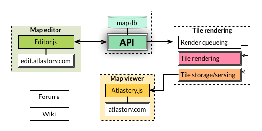
This repo contains the MVC-based API codebase (including full documentation) and database structure for all map data. Check out the Atlastory Roadmap for more on how the API fits into the Atlastory infrastructure.
The API is a Node.js application, so make sure you have it installed. To access or edit data on your own database, read "Creating the database" first.
git clone git@github.com:atlastory/api.git
cd api
npm install
# Make sure databases are created
npm startThe official Atlastory-hosted API is live at api.atlastory.com. See the API Documention for more on accessing map data through the RESTful interface. Here's a quick demo using cURL:
# Get data for an individual level:
$ curl api.atlastory.com/levels/land
> {
    "id": 1,
    "name": "land",
    "level": 1,
    "created_at": "2014-11-22T02:04:14.676Z",
    "updated_at": "2014-11-22T02:04:14.676Z",
    "types": [{
      "id": 1,
      "name": "land",
      "color_1": "",
      "color_2": ""
    }]
  }
# Get a GeoJSON of the land level for the year 1999:
$ curl api.atlastory.com/year/1999/land.geojson
> {
    "type": "FeatureCollection",
    "features": [...]
  }
For coding or development discussion, chat using the Gitter atlastory/api room. For general questions and community discussion, head to the Atlastory Google Group.
The Atlastory API is licensed under the MIT License. See LICENSE for more details. Feel free to clone, fork, or use any parts of the codebase as long as they are attributed.