🚀Added Gmplot #745
🚀Added Gmplot #745
Conversation
|
For any modifications let me know . |
Gmplot-Track the Route/README.md
Outdated
| 37.766227, -122.460213 | ||
| 37.764028, -122.510347 | ||
|
|
||
| # Author |
There was a problem hiding this comment.
| # Author | |
| # Author | |
There was a problem hiding this comment.
I got to changes which are requested but i have some doubts
- Do i remove author name from README / I mean i didn't get above review.
- Rest else is fine i will take file address as an input form user .
There was a problem hiding this comment.
No, You can keep the author name, no issues, I was suggesting to remove the space with (#) and line start as the Author level was not rendered properly.
Gmplot-Track the Route/main.py
Outdated
| gmap = gmplot.GoogleMapPlotter(20.613456, 72.9431185,17) #Plotting data on map | ||
| #gmap.coloricon="https://developers.google.com/maps/documentation/javascript/examples/full/images/beachflag.png" | ||
|
|
||
| with open('Home/MyPC/Python/LatLong.csv','r') as f: #give the address of csv file with respect to your folder containing .py file |
There was a problem hiding this comment.
ask the user to input the file path
There was a problem hiding this comment.
Requested changes are made .
Modified author's name in readme , removed unnecessary spaces
Gmplot-Track the Route/README.md
Outdated
| 37.766227, -122.460213 | ||
| 37.764028, -122.510347 | ||
|
|
||
| ### Author : [Lakhan Kumawat](https://github.com/Lakhankumawat) |
There was a problem hiding this comment.
| ### Author : [Lakhan Kumawat](https://github.com/Lakhankumawat) | |
| ## Author : [Lakhan Kumawat](https://github.com/Lakhankumawat) | |
There was a problem hiding this comment.
If i remove one # then size will be too big and it looks unusual .
If you say so i can remove .
There was a problem hiding this comment.
can remove this, we need to follow a consistent pattern
| @@ -0,0 +1,24 @@ | |||
|
|
|||
There was a problem hiding this comment.
upload the CSV to be used in the script for testing
There was a problem hiding this comment.
I think my code has some bugs i will resolve them in a day or two and will notify you.
There was a problem hiding this comment.
Okay, make sure to update it by tomorrow
There was a problem hiding this comment.
Actually i m out of town these days i will be back in 3 days so it would be great sir if you wait , please
There was a problem hiding this comment.
Oh okay, I will put the hold label for now.
|
There was a problem hiding this comment.
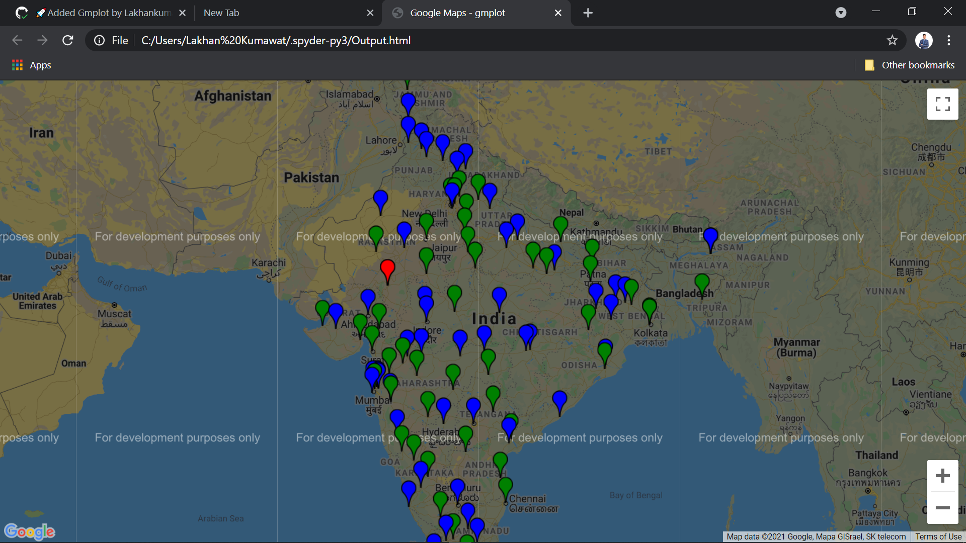
You have not done something new here: https://pypi.org/project/gmplot/. Only the coordinates loading is changed from zipping to pandas data frame. This being level2 issue needs modifications. Suggestions:
- Add some more coordinates, Indian coordinates of around 100 places.
- Here: gmplot.GoogleMapPlotter(37.771260, -122.511011,17), take input for zoom level and for central coordinates, take the average of all the coordinates for x and y separately.
Requested Changes are made
|
|
This looks good. You can make the changes in the PR |
|
Updated README request a review from other members please if it is good to go. |
Gmplot-Track the Route/README.md
Outdated
| | ------ | ------ | | ||
| | `pip install gmplot` | [Gmplot/PyPI](https://pypi.org/project/gmplot/) | | ||
|
|
||
| # CSV File Data |
There was a problem hiding this comment.
Now you can remove this section and corresponding lat-long values
Description
Tracking the route of a person OR Tracking a specific path followed by a person
Fixes #713
Have you read the Contributing Guidelines on Pull Requests?
Type of change
Checklist:
README.mdTemplate for README.md