Repository navigation
Land use modelling
Land use modelling is the process of modelling the transformation of land use and land cover over time. A land use model takes the land that different uses need, the qualities of each location and the rules that apply, and works out what land use could look like in the future.
Predicting what will happen is difficult, but a model can show what cannot happen and what is likely, given geographic restrictions and interactions. Land use models are mainly used to:
- test whether the claims of different sectors on land fit together, given the land that is available and the restrictions on it;
- project land use on a map, given these claims and the characteristics of each location; and
- assess the effects of land-use change on indicators such as food production, housing supply, carbon and nitrogen emissions, natural habitats and flood risk.
Because the future is uncertain, the results are usually explored with several scenarios rather than presented as one forecast.
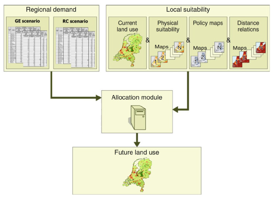
Figure 1. The structure of Land Use Scanner: regional demand and local suitability go into the allocation module, which produces a map of future land use.
Figure 1 shows the structure that many land use models share. These are its parts:
- Land use types and land units set the terms: what is allocated, and to what. Some types are not allocated but read from a map.
- Regional demand says how much land each type needs in each region.
- Suitability says for each land unit how attractive it is for each type. It is built from driving factors such as soil, restrictions and the surrounding land use. Accessibility is an important driving factor in many models.
- Allocation brings demand and suitability together and decides which land use goes where. The main methods are continuous allocation and discrete allocation.
- Scenarios vary the demand, the suitability and the planned developments to explore different futures.
- Calibration and validation test how well a model reproduces observed land use.
From the resulting maps, a model can derive indicators that help to assess the impact of a scenario or policy.
GeoDMS was initially developed to support land use modelling. Land Use Scanner is a prime example of a model built with it and is extensively used in Dutch spatial planning. Models gives an overview of this and other models. To see how such a model is set up, you can run the Land Use Scanner demo.
- Land change modelling, also called dynamic land use or land cover simulation
- Land Use and Transport Interaction (LUTI)
- Accessibility modelling
