[CI Bot] environment lockfiles auto-update #5113
Conversation
1a6e592 to
c208b8e
Compare
|
Looks like we might need #5098 for this one, as we just have more of Antarctica showing... ... though I'm not clear why or whether we should be seeing more of Antarctica: the latitude coordinate doesn't go below 80S 🤔
|
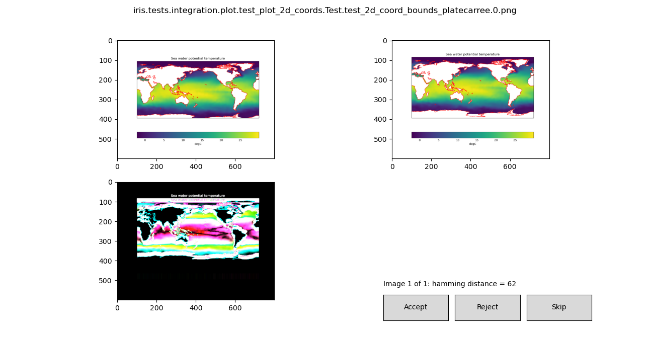
Patch releases of Cartopy and PyProj seem like candidates for an unintended change. I'm not aware of any Minor/Major releases that might have deliberately changed behaviour. Maybe Shapely? Maybe an interaction between Cartopy and Shapely? I know that was giving the Cartopy devs some grief. |
c208b8e to
55e355c
Compare
55e355c to
4572a2b
Compare
|
Have proved during local testing that Shapely causes the change in
|
|
The change in Shapely version has stumbled across a problem that already existed at different It is difficult to know how to address this. The behaviour already existed and the test was just getting lucky at avoiding it. Meanwhile the test has already set a precedent of using specific settings to avoid another known problem (see SciTools/cartopy#1421): iris/lib/iris/tests/integration/plot/test_plot_2d_coords.py Lines 39 to 43 in 34560a5 Possible ways forward:
|
4572a2b to
248d5ba
Compare
|
I propose option 5:
The problems that this would hide are not Iris’ problems and, as you say, the test “is still demonstrating other correct behaviours”. The test presumably exists to check that Since you found that the problem exists with older Shapely but different longitudes, I don’t think it makes sense to pin. |
@rcomer I'd appreciate your experience with this method. I tried a few different arguments last week and they were not producing the desired result. (I saw some suggestion of using |
It's my understanding that set_xlim / set_ylim don't work for geoaxes, and you must use set_extent instead. Always been poorly explained IMHO, but it is the kind of thing which doesn't fit too well in the Cartopy doc style. |
|
Hmmm, set_extent uses the axes’ projection by default, so I would have expected something like ax.set_extent((0, 360, -80, 90))to Just Work. I must admit I didn’t try it though. Could use |
|
Replaced by #5132. |
Lockfiles updated to the latest resolvable environment.
If the CI tasks fail, create a new branch based on this PR and add the required fixes to that branch.