Repository navigation
Triangulation
Triangulation estimates where a transmitter is from the signal levels measured by several receivers.
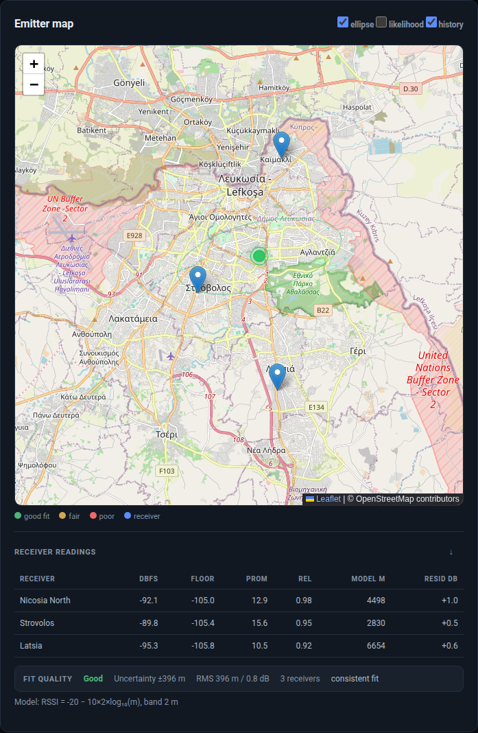
- Every enabled receiver measures the target frequency.
- The log-distance path-loss model converts RSSI to a distance:
d = 10 ^ ((P0 - RSSI) / (10 * n)) - Each receiver therefore defines a distance circle around its position.
- The solver finds the point that minimises the weighted Huber loss across all circles.
- A numerical Hessian produces the confidence ellipse and the reported uncertainty.
Huber loss is used instead of plain least squares because RSSI varies with multipath. A single faded receiver can move a least-squares fix by kilometres; Huber limits that influence.
- At least two enabled receivers with coordinates
- Three or more for a meaningful fix; two are underconstrained and the UI reports that explicitly
- A measured signal at the target frequency. Weak readings are labelled and excluded or used as a low-confidence fallback
Add receivers from the dashboard or CLI:
spectrum-alert geo add-receiver Home --lat 35.130 --lon 33.310 --gain 30 --ppm 20
spectrum-alert geo add-receiver Hill --lat 35.080 --lon 33.380 \
  --mode rtltcp --host 10.0.0.5 --port 1234
spectrum-alert geo receivers- Open Workspace.
- Select the target frequency or click the waterfall.
- Press Triangulate.
- Read the map and the receiver readings table.
The map shows:
| Layer | Meaning |
|---|---|
| Blue pins | Receivers with coordinates |
| Green/amber/red marker | Estimated emitter, coloured by fit quality |
| Filled circle | Reported uncertainty radius |
| Ellipse | Confidence region |
| History | Previous fixes, if enabled |
The readings table reports:
| Column | Meaning |
|---|---|
| dBFS | Measured level at the target |
| Floor | Local noise floor |
| Prom | Prominence above the floor |
| Rel | Measurement reliability |
| Model m | Distance implied by the RSSI model |
| Resid dB | Measured minus predicted level |
Quality is graded good, fair or poor from:
- RMS RSSI residual
- RMS distance residual
- Receiver geometry and spread
- Confidence-ellipse size
- Outlier behaviour across receivers
The quality reasons are returned with the fix and available in the map popup instead of being reduced to a colour.
# Scan one frequency from every enabled receiver
spectrum-alert geo triangulate 446100000

# Calibrate receivers against known transmitters before locating
spectrum-alert geo calibrate
spectrum-alert geo calibrate --apply

# Fit the path-loss exponent to the local environment
spectrum-alert geo fit-ple
The web API exposes the same operation:
curl -X POST localhost:8000/api/triangulate \
  -H 'Content-Type: application/json' \
  -d '{"frequencyHz": 145312500, "windowHz": 12000, "integrationSec": 0.5}'
You can also send readings measured elsewhere:
curl -X POST localhost:8000/api/triangulate/readings \
  -H 'Content-Type: application/json' \
  -d '{
    "frequencyHz": 145312500,
    "readings": [
      {"id":"north","name":"North","lat":35.185,"lon":33.382,"rssiDbm":-92.1},
      {"id":"central","name":"Central","lat":35.130,"lon":33.340,"rssiDbm":-89.8},
      {"id":"south","name":"South","lat":35.090,"lon":33.380,"rssiDbm":-95.3}
    ]
}'- Calibrate every receiver against a known transmitter.
- Use three or more receivers with good angular spread; collinear receivers produce a long, uncertain ellipse.
- Avoid placing all receivers at similar distances from the target.
- Fit the path-loss exponent for the local environment.
- Treat a fix with a large residual or a high
Resid dBon one receiver as suspect.
Readings are dBFS. Calibration offsets convert relative levels to a consistent scale across receivers; without calibration, receiver gain differences are indistinguishable from distance differences.