Introduction to the OpenStreetMap Project

OpenStreetMap is an online open data platform to collect the world's geographic data based on the Wikipedia model of crowdsourcing. The project started in 2004 by Steve Coast and is now governed by the non profit OpenStreetMap Foundation based in the UK.
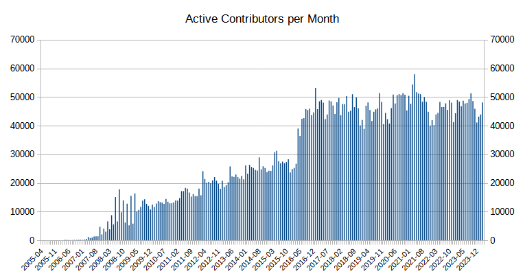
What started as an interesting idea in 2004 with a handful of volunteers has grown to a global movement on the scale and importance of Wikipedia. In 10 years, the project has over 2 million registered users and over 20,000 active contributors every month, mapping out their neighborhoods and countries using GPS devices, field surveys and satellite imagery tracing as a hobby.
The result is a living map of the world made by the citizens of earth on a level of detail that is unparalleled in human history. For some amazing visuals, see this video or explore the edits over 10 years

The primary documentation about the project is available on the OpenStreetMap Wiki while discussion takes place over the various talk mailing lists and the oftc #osm IRC channel (try it out!).
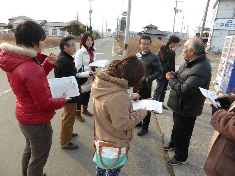
Mappers worldwide meet each other and organize social events like mapping parties to make it fun to explore neighborhoods and make new friends. You can organize one too, just create a page on the wiki with details and spread the word on your local mailing lists.
OpenStreetMap as a community, runs yearly international conferences called State of the Map. 2007 was the first year this conference was conducted in England. Since then the community has run 9 conferences each with registering massive growth from the previous year. One can imagine the growth of this community from around 200 attendees in the year 2014 to around 740 people from 40 different countries attending the 2015 conference held in New York City.

What allows this community to thrive is that the map data is Open and Free:
- Anyone can alter the vector map database comprising the raw geometries and properties by creating, updating or removing objects with a free user account
- Anyone can download the entire raw map database for their own application, commercial use or research
- Anyone can view the history of changes of any map object or any other user in the system
Usage of the geodata is controlled by a license called the Open Database License (ODbL) which broadly states that:
- you do not have to pay anybody anything or ask permission to use the data
- you may use the data for personal, community, educational, commercial, government or any other use that you can think of
- you must attribute
OpenStreetMapin your resulting project - if you make any additions or enhancements to the data, you must release the resulting data under the same terms as above.
The principle behind the last point is called "share-alike" and is causing issues with data license compatibility.
The OpenStreetMap Foundation (OSMF) is responsible for ensuring that the project and collected map data is free and openly accessible to anyone in the world by supporting infrastructure costs through annual fundraising drives. The foundation constitutes a democratic body of elected members from the OpenStreetMap community and has the final word in the case of disputes in the project.
The rich mapping data collected by volunteers around the world has resulted in an open map database that is vastly more detailed, customizable and maintainable than any proprietary map database on a global scale. This has made it highly attractive for businesses to use OpenStreetMap data to bring down the cost of creating and maintaining map data which is an extremely costly operation. Successful organizations have made use of OpenStreetMap data as the source data on top of which they create mapping services that can be monetized.
Major corporate supporters of OpenStreetMap from the past include Yahoo!, MapQuest, Microsoft Bing, Telenav, Cloudmade, Geofabrik, Mapzen, Mapillary and Mapbox.
To get a better understanding of the changing digital mapping landscape, take a look at these articles:
One of the most valuable applications of open map data has been in disaster relief operations in times of crisis. To address a need to have a coordinating body between the data requirements of ground rescue teams and the OpenStreetMap volunteer community, the Humanitarian OpenStreetMap team formed in 2010 after the utility of open map data was proven during the 2010 Haiti earthquake and more recently during the 2015 Nepal earthquake. Since then the HOT has been involved in several activations bringing the power of the OpenStreetMap community to the hands of those who needs them the most.
