Tile combination by zoom level#3704
Conversation
|
|
|
@jesusbotella Thank you for the detailed probe into this issue. If I understand it correctly, your proposal is to merge all visible tiles into one dataset (layer) per zoom level. I have some concerns about introducing the new "combined tile" concept:
I think the root issue in the original approach was that we call Edit: I put together a proof of concept: https://github.com/uber/deck.gl/compare/x/tile-layer-cache?expand=1 Could you give it a test? |
|
Thank you for the fast response @Pessimistress. Yours are fair concerns that conflict with this approach of combining all tiles' data into a single tile. Could you please elaborate more on the first issue? I would like to fully understand what it is about. And thank you very much for putting together that proof of concept, I tested it thoroughly and it dramatically improves the animation frame handler execution times. Would you have plans of developing/merging that improvement to the master branch in the near feature or do you want us to take a further look into it? We're really interested in that improvement. Our particular interest in combining tiles comes from the use case of rendering MVT tiles as you had in your TileLayer example, and especially when it comes to rendering polygons split into different tiles. Seeing that this approach is not feasible for a general TileLayer, do you think it would make sense to create a more specific MVTTileLayer for that? The issue with the polygons, as you may imagine, is that as polygons are cut between tiles, the representation is not ideal because of the tile border axis. We came up with a mechanism to merge all the parts into one polygon and then represent it within the "global" layer. But if we don't have a single tile, we would need to link the polygon to a specific tile and then omit it in other tiles. |
If we combine all visible tiles into one layer, then as you pan around and tiles load, that layer needs to reprocess all geometries that are visible, instead of those of the newly loaded tile. The cost of this depends on how much data is visible in one viewport.
I'm glad that it works well! I will open a PR. Timing is a little awkward given that we are publishing 7.3.0 today. We can discuss whether this change can be justified as a patch.
That is a fair point that this layer does not properly address right now. I think a dedicated |
Yes, sure, it makes sense. I understand your point now.
Ok, I'll follow that PR to keep in touch with this!
I'm using For the merging approach, I had a features' store and then I was merging polygon vertices grouped by a unique property (defined by the user/developer) shared among features. That was the first approach but we are doing performance reviews and we might change it for a better approach. |
|
Going to close this PR because perfomance improvements have been merged into master. We'll open up a new PR once we have our geometry merge changes ready to be shown and discussed. Thank you very much! |
For #3695
Background
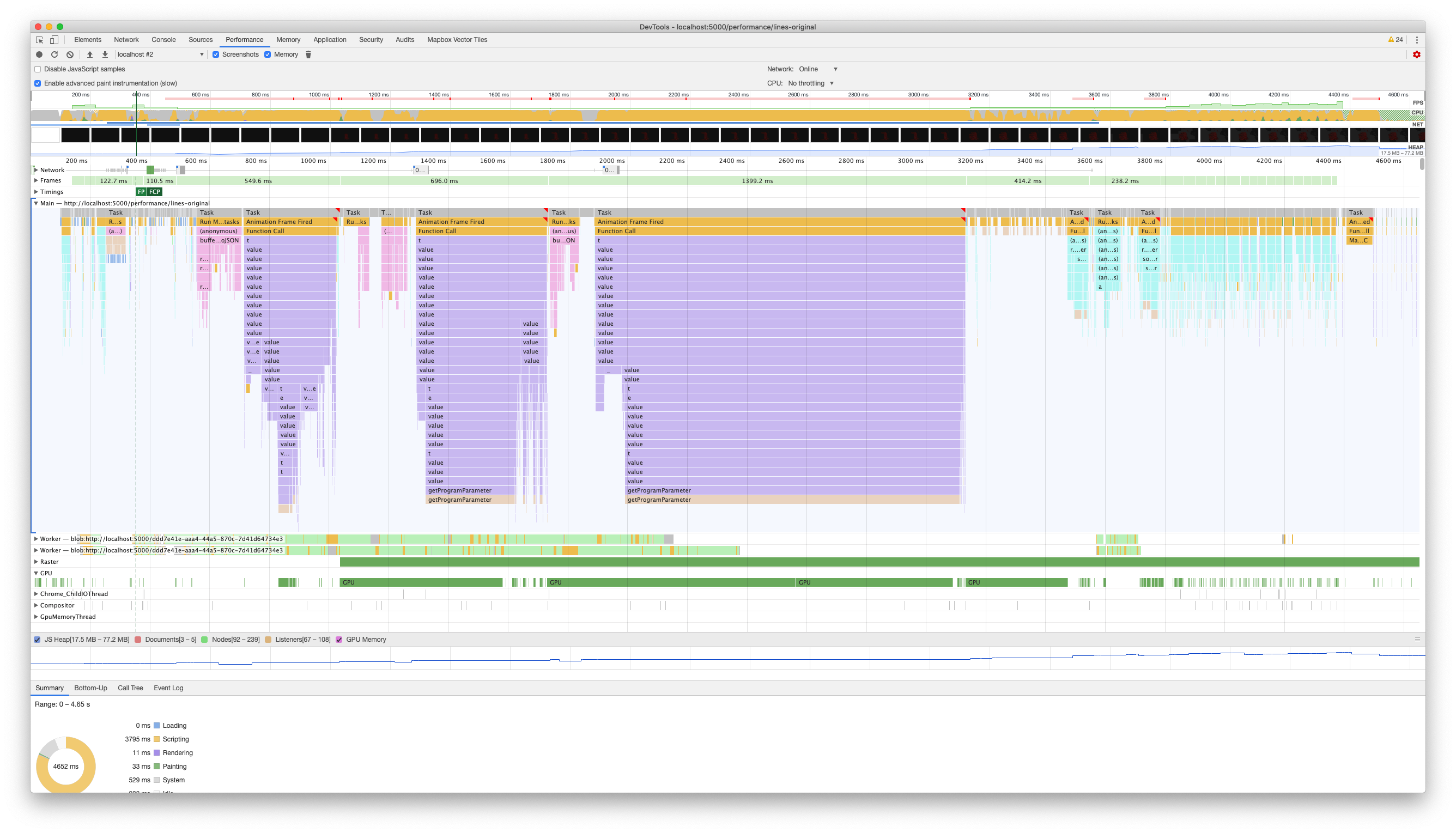
While using Deck.gl's TileLayer implementation to render MVT tiles retrieved from our backend, the main issue that we found is that the tile rendering process takes more time than it should to avoid lag and provide a nice user experience while panning and zooming the map.
Understanding Deck.gl's TileLayer behaviour, we found out that the TileLayer is a CompositeLayer that renders N sublayers (GeoJSON layer by default), two for each of the tiles within the viewport at least.
Viewport in a 1080p display at fullscreen contains 24 tiles, excluding the main TileLayer and derived layers from points, lines and polygons, which could make a total of 49 layers (or even almost 2x with polygons and fill and stroke layers) if every tile contains 1 geometry at least.
Performing analysis using Chrome DevTools' performance tool, the rendering process for a dataset with 16k lines takes an avg. of 1062ms taking a sample of 10 executions, which is way more to what it is recommended to avoid lag or hangs when interacting with the content.
This is how the flame chart looks like:
Proposal
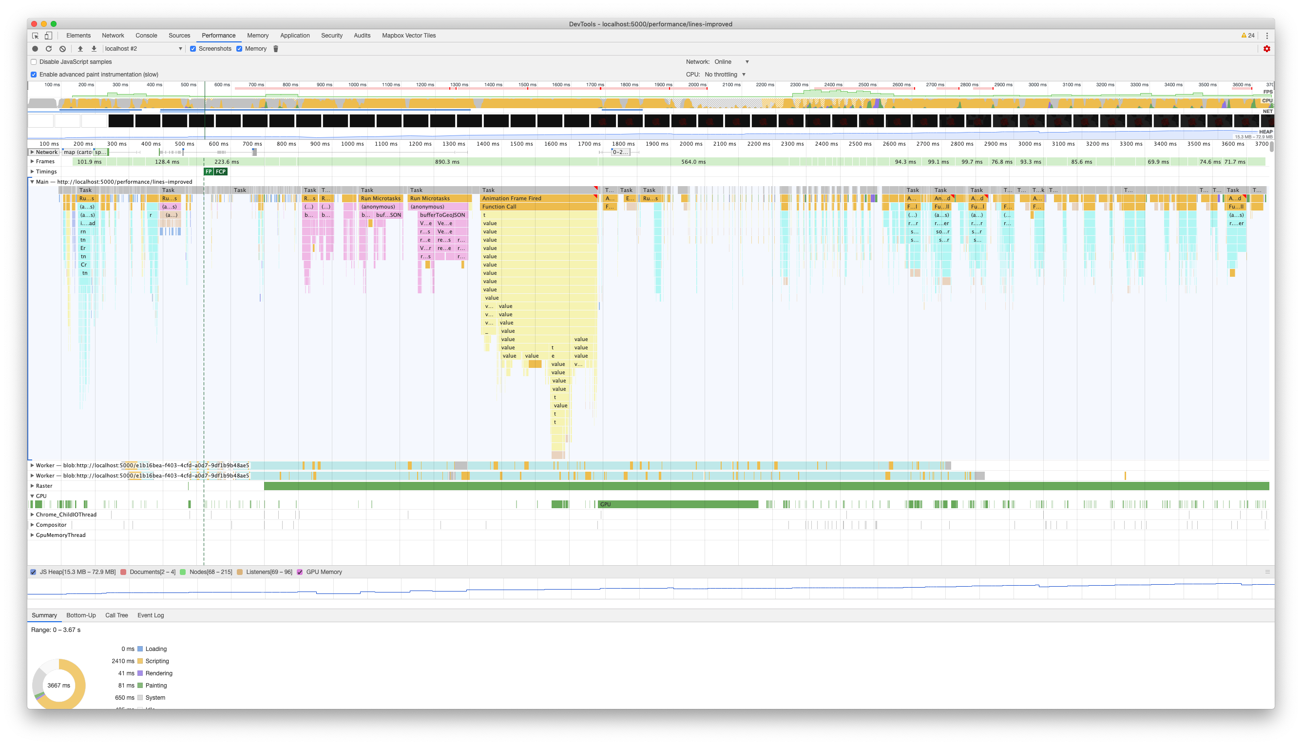
We thought of combining all tiles within a single zoom level into a single tile to ease the rendering process and make it faster. This is what changes are about in this PR.
We introduced a new concept called CompositeTile, which is just an abstraction for holding a set of tiles and taking care of all data management so that we only create a single layer in
renderLayersmethod.That way we would only render 3 or 4 layers at most in each renderLayers cycle, lowering the time that each requestAnimationHandler cycle takes, and improving the performance.
This is how the flame chart looks like:
We created a set of different examples with different geometries to assess our performance improvements. Those examples are here: https://deck-comparisons.glitch.me. You will find there the examples with the dataset specifications.
Performance Improvements
We performed a set of performance comparisons between the production version of Deck.gl and our custom Deck.gl version with those changes applied.
Tests were executed with the same configuration as in the screenshot above (local assets, advanced paint instrumentation enabled, and no CPU throttling). Measures are taken from the latest animation frame where all layers are rendered to avoid flakiness or tests variation due to network fluctuations.
These are the stats that we got:
Points' example - 500k points
Lines' example - 16k lines
Percentages of improvement seem good in both cases and we would like to know what you think about this approach of combining tiles, and if it is good to go for this approach.