Components
The Geoportal Server is a fully functioning web site with a set of application components that allow the publication, discovery and use of standards-based metadata documents describing geographic datasets and services. An in-depth understanding of the Geoportal Server components is not required to install or use the Geoportal Server; however, understanding its components will help your organization as it customizes the geoportal to meet its needs. This topic gives an overview of the Geoportal Server components; for details on specific components, see the following topics:
- Geoportal User Interface Components
- Geoportal Web Application File Organization
- Identity Components: LDAP and Single Sign-On
- Geoportal XML Editor
- Publication Components
- Database Tables
- Search Components
- Catalog Service
- Preview Function
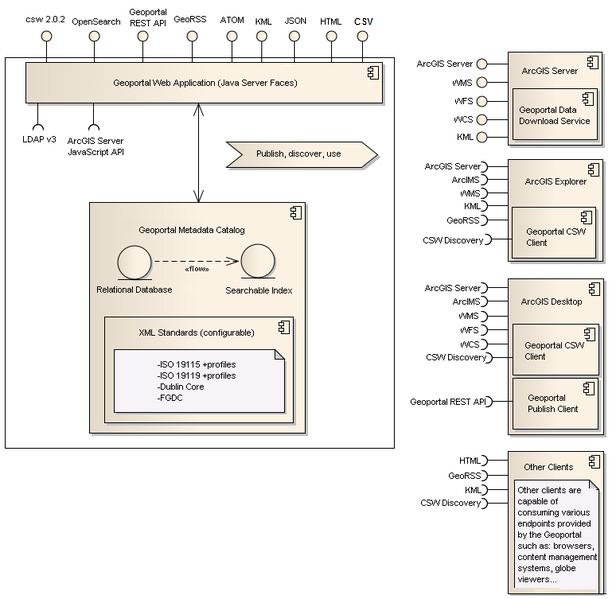
The primary focus of the application is to allow for the publication of metadata documents, the discovery of these documents through a variety of search protocols, and enabling the use of the underlying services and datasets by binding to external client applications through known protocols.
The application manages a catalog of metadata documents describing geographic datasets and services based upon known XML metadata standards. The following standards are all recognized and supported by default: ISO 19115/19139 (datasets), ISO 19119/19139 (services), Dublin Core, and FGDC. The following standards based profiles are also recognized and supported by default: North American Profile, UK Gemini profile, and INSPIRE. These standards and profiles can be enabled, disabled, or extended upon through configuration (see Custom Metadata Profiles). A relational database serves as the primary store for documents, and a searchable index is implemented allowing for discovery.
The primary application is a web site built using JavaServer Faces (JSF) technology. The website provides pages allowing for catalog maintenance, publication, and searching (see Geoportal Web Application File Organization for details about the pages in the website web application). The website also exposes several service endpoints allowing external client access to the catalog:
- CS-W 2.0.2 Discovery service endpoint (see Catalog Service) - exposes an OGC Catalog Service end point allowing query access into the catalog by CS-W compliant clients
- REST Services endpoint (see REST API Syntax) - exposes a query endpoint that can return GeoRSS, KML, ATOM, JSON, CSV (version 1.2 and up), HTML, and HTML fragment responses to compliant clients (e.g. browsers, content management systems, ArcGIS Explorer, Google Earth )
- OpenSearch endpoint - exposes an endpoint allowing query access into the catalog by OpenSearch compliant clients
ArcGIS Server has the capability to provide geographic services to external clients by exposing ArcGIS Server, OGC WMS, OGC WFS, OGC WCS and KML end points. The Geoportal Data Download customization (see DataDownload Tab) is a configurable geoprocessing service that can be deployed within an ArcGIS Server, and is capable of executing data download requests submitted by a compatible client (e.g. the geoportal web interface itself is a client of this service).
ArcGIS Desktop is a powerful GIS desktop system that is capable of consuming ArcGIS Server services, ArcIMS services, OGC WMS services, OGC WFS services and OGC WCS services. The Geoportal CSW Clients gives ArcGIS Desktop users the ability to query CSW compliant catalogs. The Geoportal Publish Client gives ArcGIS Desktop users the ability to recursively publish metadata documents contained within folders or geo-databases to the geoportal metadata catalog.
Back to Development Topics