Features
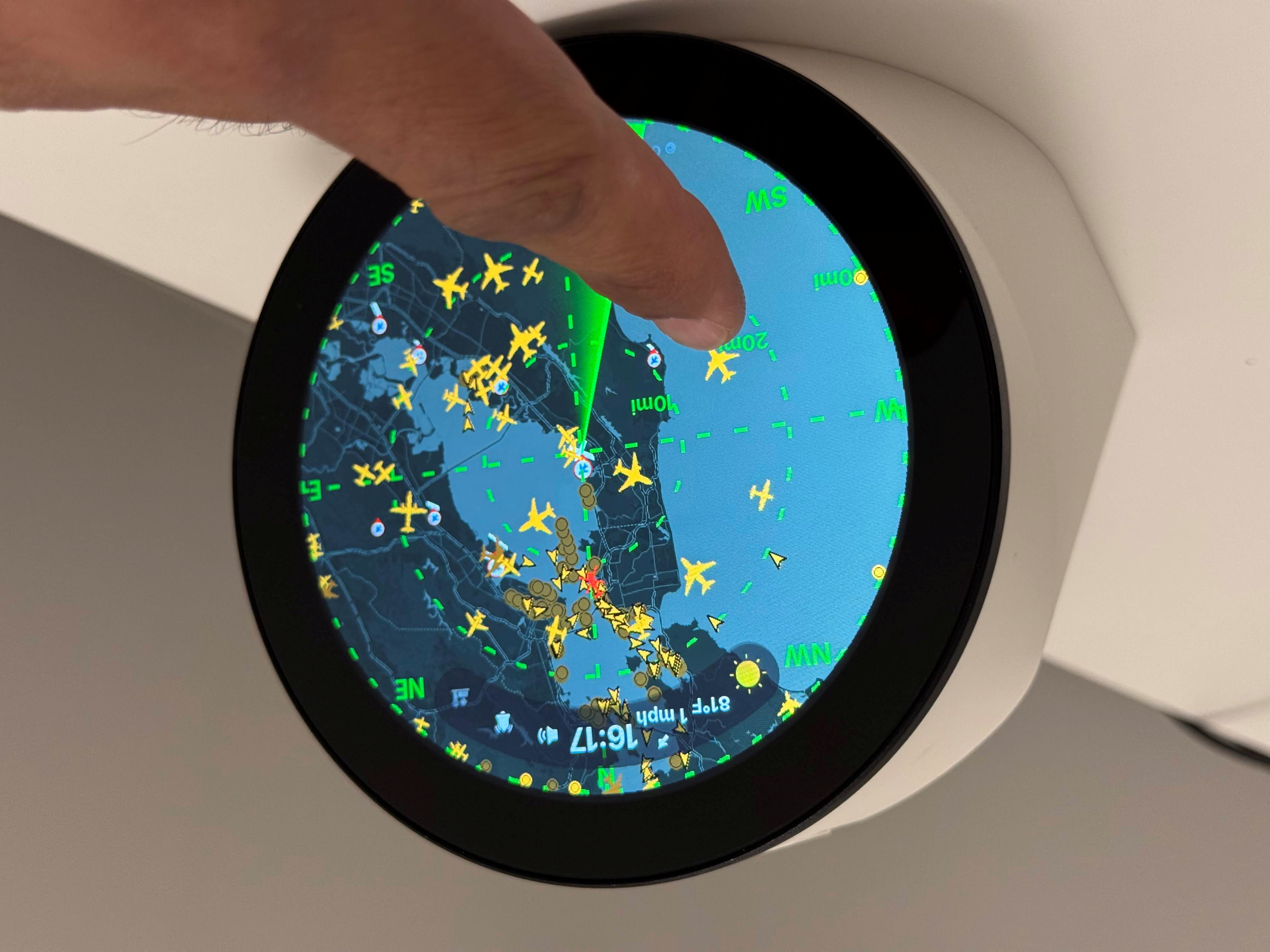
FlightScnr Pi shows live aircraft around your location on a circular radar, with rich flight details when you tap a plane. It combines FlightRadar24 (FR24), live positions from adsb.fi (free cloud feed — no local ADS-B dongle), optional local dump1090/readsb, Tomorrow.io weather, and optional AirLabs / FlightAware AeroAPI route enrichment.
Settings, API keys, tracking, and updates are managed through the Web-Portal. See Data-Sources for the full source list.
The UI is designed for a 4″ round LCD with touch (default layout: 720×720).
| Screen | How to open | What you see |
|---|---|---|
| Radar | Boot / home | Live aircraft, map background, sweep line, compass rose, range label, altitude tags |
| Flight detail | Tap aircraft on radar | Airline logo, route, type, altitude, speed, heading; swipe or footer to cycle aircraft |
| Tracked flight | Web portal → Track, or swipe right on radar | Route header, progress bar with aircraft icon, LIVE/ETA, vertical speed ticker; pin to keep screen open |
| Clock and current weather | Swipe down from radar | Time, date, current weather and conditions |
| Weather Forecast | Swipe right from clock | Multi-day forecast (Tomorrow.io) |
| Clock settings | Swipe left from clock | Clock format and related options on-device |
| About / details | Swipe up from radar | Version, network, API status, portal URL |
| Settings | Swipe left from radar | Brightness, timeouts, color theme, facing direction, display options (multi-page) |
| Wi‑Fi setup | Automatic when offline | QR code to join the FlightScnr setup hotspot, then finish on your phone |
 ·
· 
 ·
· 
- Tap aircraft → flight detail
- Tap range label (top) → cycle zoom presets (2–30 mi / km / nm)
- Two-finger pinch → zoom radar range in and out
- Swipe between screens (see table above)
- Footer buttons on detail, tracked, and settings screens (PREV / NEXT / RADAR / PIN)
- Auto-return to clock when no aircraft are visible (optional, portal setting)
- Off-hours schedule can dim the panel, turn it off, or force the clock screen at night
- Animated radar sweep with configurable accent color themes (Red, Yellow, Green, White)
- Optional compass rose and sweep line (toggle in portal)
- Facing direction — rotate the radar so “up” on the screen matches how the Pi is physically mounted
-
Map tile background — dark/light CARTO street maps, or free FAA VFR sectionals (US); cached under
/var/lib/flightscnr/maps/ - Aircraft-type icons (jet, turboprop, helicopter, military, etc.) with altitude/speed tags
- Minimum altitude floor to hide low aircraft (e.g. pattern traffic)
- Alert mode: highlight military aircraft, emergency squawks (7700/7600/7500), or a custom watch list; optionally hide non-alerted traffic
- Distance units: km, statute miles, or nautical miles
By default the radar is north-up. If the display is mounted so the top of the screen does not face north, set a facing direction so aircraft and the compass rose match the real world.
Facing is the real-world direction at the top of the screen: 0 = north, 90 = east, 180 = south, 270 = west (any 0–359° value is allowed).
On the device
- Swipe left → Settings → Display → tap Facing
- Traffic drawing and ADS-B refresh pause; drag around the screen to rotate the rose, crosshairs, and map
- Tap center to save, or tap the rim to cancel
On the web portal
-
Radar → Facing direction (degrees) → enter
0–359→ Save radar settings
Stored in /var/lib/flightscnr/round_touch_settings.json and survives updates.
Pick any callsign in the web portal. The display shows origin → destination, aircraft type, a progress bar with a moving plane icon, and live stats (time remaining, distance, vertical speed). Flights not yet airborne can use AirLabs schedule data when configured.
Flight detail can show a photo of the aircraft when one is available. Lookups use the public planespotters.net API (by ICAO hex / registration), with Wikimedia Commons as a type-based fallback. Photographer credit is shown on screen when the source provides it.

Marine traffic uses live AIS from aisstream.io when enabled (portal → Radar → traffic mode, plus an API key). Vessels appear on the same radar as aircraft. Vessel detail photos are fetched from Wikimedia Commons by ship name / IMO when possible.

 ·
· 
Optional wildfire markers on the radar:
| Region | Source | API key? |
|---|---|---|
| California | CAL FIRE | No |
| Rest of USA / Canada | NIFC WFIGS (AirNow large-fire layer) | No |
| Outside USA / Canada | NASA FIRMS VIIRS NRT | Free MAP_KEY under portal → API Keys |
Fire Details shows name, county, acres, and containment when the source provides them. Enable Show wildfires (Radar card or Settings → Options). Tap a fire icon for details. Data refreshes every 15 minutes and immediately after recenter or boot.
