Repository navigation
Moving Map
The moving map shows where you are over terrain, water, roads, airports, navaids
and the flight plan. On the bench panel it fills the Map tab of the
right-hand tab column. The instrument type is moving_map.
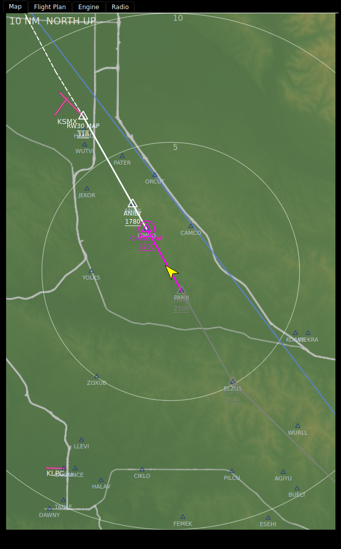
| Element | What it shows |
|---|---|
| Status chip (top left) | The range and orientation: 10 NM NORTH UP or 10 NM TRK UP. NO POS is added when the position is stale. |
| Ownship | An arrow pointing along your ground track, yellow by default. It turns grey when the position is stale. |
| Range rings | Rings at half and full range by default, labelled with their distance in nm. |
| Terrain | Shaded relief coloured by elevation, from green at sea level to white at 14,000 ft, lit from the north-west. Water is blue. |
| Roads | Grey, wider and bolder for bigger roads. |
| Rivers | Thin blue lines. |
| Airports | Magenta. A hard-surface airport is a circle with its runways drawn inside at their real orientation. A field with a runway over 8,069 ft shows the runways alone, and a soft field is a plain circle. Zoomed in far enough, runways draw to true size. |
| Navaids | A VOR is a hexagon with a centre dot, an NDB a stippled disc. The label is the ident, with the frequency at 40 nm and below. |
| Waypoints | Open triangles with idents, at 20 nm and below, when the layer is on. |
| Airways | Blue lines, with each airway's ident at 80 nm and below, when the layer is on. |
Towered and untowered airports look the same today; there is no airspace or obstacle layer on the map.
| Drawn as | Means |
|---|---|
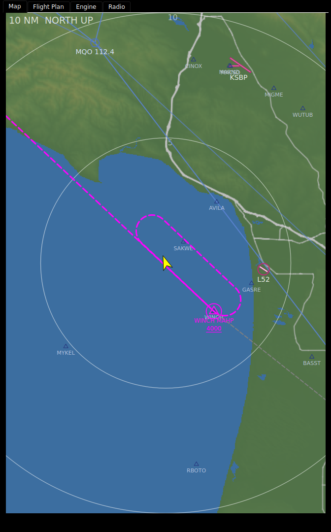
| Magenta line | The active leg. The waypoint you are flying to is ringed in magenta. |
| White line | Legs ahead. |
| Grey line | Legs already flown. |
| Dashed line | Missed-approach legs. |
| Dotted line | Vector legs. |
| Racetrack | A hold or procedure turn, drawn as its pattern. |
| Magenta line from where you were | An off-route Direct-To. |
| Dashed magenta line past the runway | The extended final course, 5 nm, while the plan is suspended at the missed approach point. |
Waypoint symbols follow their type: hexagon for a VOR, stippled disc for an
NDB, triangle for a fix, circle for an airport, filled diamond for a user
waypoint and filled square for a point made on the map. Labels carry IAF,
FAF, MAP or MAHP where the procedure says so, and altitude constraints
are drawn with chart-style bars: a bar above for at-or-below, below for
at-or-above, both for at. Where the airport, navaid or waypoint layer already
shows the place, the plan keeps that layer's symbol and ident and adds only
the ring and the role.
| Item | Shown at or below |
|---|---|
| Waypoints | 20 nm |
| Airport idents, navaid frequencies | 40 nm |
| Airport symbols, airway labels, flight-plan labels and constraints | 80 nm |
| Navaids, airways, flight-plan symbols | 160 nm |
| Roads | 5 nm for secondary roads up to 80 nm for motorways |
Where airports crowd together, the two with the longest runways in each patch of the map are kept.
With nd_mode: expanded the map is drawn as a navigation display. It is
always track up, whatever orientation says, and ownship sits 82% of the way
down, whatever ownship_position says. The selected range reaches the compass
arc instead of the top edge.

| Element | What it shows |
|---|---|
| Compass arc | At the selected range, ticks every 5°, a numeral every 30° in tens (6 is 060). |
| TRK box |
TRK, the magnetic track and MAG over the top of the arc, with a pointer under it. Grey when TRACKM is stale. |
| Top left |
GS and TAS, then the wind as direction°/speed with an arrow pointing the way it blows. |
| Top right | The active waypoint in magenta, its ETA in UTC (HHMM.Mz, now plus WPETE) and its distance in NM. Only while a plan is active (FPLSTATE not 0); ETA and distance are left out in the VECTORS phase. |
| Bottom left | The map layers that are on, in cyan: ARPT (airports), WPT (waypoints), STA (navaids). |
| Vertical deviation scale | Right edge, from GSI, with a magenta diamond pointer. Hidden when GSV is published and below 0.5 (no glidepath). A red GS flag shows when GSV says a glidepath is present and GSI is bad or failed. |
A failed value in a data block reads red XXX; an old or bad one is grey. A
key fix-gateway does not define is left out.
With nd_mode: ctr the map shows the same elements around a full compass rose,
with ownship at the centre of the panel. The rose is at the selected range, so
the range reaches the same distance ahead and behind. It is sized to fit the
panel under the TRK box, clear of the deviation scale.

- Zoom: pinch, or the mouse wheel on a desktop. Zoom is continuous between the smallest and largest range on the range ladder. Buttons or a knob bound to the map step through the ladder's ranges instead.
- Pan and rotate: drag to pan; twist two fingers to rotate. Shift- or Ctrl-drag rotates with a mouse.
- Back to your position: double-tap, or tap the amber CTR chip in the top right. The map re-centres by itself 30 seconds after the last gesture.
- Orientation is track up or north up. It is set in the configurator, or switched by a key bound to the map.
Tap a symbol and the map puts a pointer on it and opens a banner along the bottom: the ident and type, then the bearing and distance from you, the terrain elevation and any frequency. Tap where several symbols overlap and you get a list to choose from; tap open ground and you get a MAP POINT at that position.

| Key | What it does |
|---|---|
| DIRECT TO | Fly direct to it. A toast says DIRECT TO <ident>, or REJECTED: and the reason. |
| INSERT | Insert it into the flight plan, in the nearest leg. |
| CREATE WPT | Make a user waypoint here, on the Flight Plan tab. |
| INFO | Open its details on the Flight Plan tab. |
| X | Close the banner. |
DIRECT TO and INSERT need fix-gateway's flight-plan engine; without it they are greyed. CREATE WPT and INFO bring the Flight Plan tab forward. See Flight Plan.
-
NO POSand a grey ownship:LATorLONGis stale. The map stays at the last position it had. - A layer is empty: its navdata pack is not installed, or its path is not set. The map does not say which; check Data Status.
Select the map in the Panel Editor; its options are in Properties. The most used, with defaults and the bench panel's value where it differs:
| Option | Default | Bench | What it does |
|---|---|---|---|
Range (range_nm) |
10 nm | Distance from the ownship to the top edge at start; to the compass arc in ND mode. | |
Range ladder (range_ladder) |
2,5,10,20,40,80,160 |
2,10,50,200,500,2000 |
The ranges the buttons step through; also the zoom limits. |
Range control key (range_key) |
A FIX key that steps the range. | ||
Zoom rail (zoom_rail) |
off | A one-finger zoom strip down one edge. | |
Orientation (orientation) |
track_up |
north_up |
|
Orientation control key (orientation_key) |
A FIX key: 0 track up, 1 north up. | ||
ND mode (nd_mode) |
off |
expanded draws the ND EXPANDED MAP; ctr draws CTR MAP. |
|
ND mode control key (nd_mode_key) |
A FIX key: 0 off, 1 expanded, 2 ctr. | ||
Touch gestures (touch_gestures) |
on | Off ignores every touch and the wheel. | |
Gesture auto-revert (gesture_timeout) |
30 s | 0 stays where you leave it. | |
Ownship position (ownship_position) |
50 | Percent up from the bottom; 30 shows more ahead. | |
Map style (map_style) |
standard |
nav_only drops the relief for a black background. |
|
Terrain mode (terrain_mode) |
relief |
caution colours terrain amber within 1,000 ft below you and red within 100 ft or above. |
|
| Layer: terrain / roads / rivers / airports / navaids / flight plan / range rings | on | ||
Layer: waypoints (layer_fixes) |
off | on | |
Layer: airways (layer_airways) |
off | on | |
Range ring fractions (range_ring_fractions) |
0.5,1 |
||
| Terrain tile path, Airport db path, Navaid db path, Roads db path, Water db path | the installed packs | Where each navdata pack is installed. |
Ring colour, width and label position, road and river colours, the water rendering options and the gesture thresholds are in the same Properties list.
Trimmed from the bench panel:
- type: moving_map
  options:
    orientation: north_up
    range_ladder: 2,10,50,200,500,2000
    layer_airways: true
    layer_fixes: true
    terrain_mode: relief
    tile_path: /data/makerplane-data/terrain/tiles
    nasr_db_path: /data/makerplane-data/navdata/current/airports.sqlite
    navaid_db_path: /data/makerplane-data/navaids/current/navaids.sqlite
    water_db_path: /data/makerplane-data/water/current/water.sqlite
highway_db_path: /data/makerplane-data/highways/current/highways.sqliteThe map reads LAT, LONG, TRACKM, ALT and MAGVAR, and the flight-plan
keys fix-gateway's flight-plan engine publishes. ND mode also reads GS, TAS,
WINDDIR, WINDSPD, WPDIS, WPETE, GSI and GSV. It writes DTOID, DTOLAT,
DTOLON, DTOTYPE and FPLCMD for a Direct-To, the route block for an
insert, and the range index to range_key when one is set. See
FIX Database Keys.
- Flight Plan
- The HSI
- Flight Plan Engine (fix-gateway wiki)