Khe Sanh Visual Briefing
A picture brief for Caucasus - Khe Sanh: Operation Niagara — real maps and aerial photography of the 1968 siege. For the full text product — the historical intelligence assessment, threat card, and read-aloud brief — see khe-sanh-intel-assessment.md; for the working brief-builder, the Campaign Briefing Handbook.
🟢🟡 Rooted in history. The map and aerial below are the real siege, mapped onto the Caucasus terrain for play. All imagery is public domain (US Government works) — full attribution in Image credits. Gameplay concessions (token MiG-17s, deep-rear SA-2, modern module stand-ins) are flagged in the intel pack.
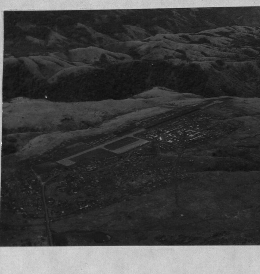 Khe Sanh Combat Base from the air, 1967 — the airstrip on its plateau, ringed by the hills the
NVA would seize. This is the field that must be kept alive by air alone — Kutaisi in the campaign.
USMC photo (public domain).
Khe Sanh Combat Base from the air, 1967 — the airstrip on its plateau, ringed by the hills the
NVA would seize. This is the field that must be kept alive by air alone — Kutaisi in the campaign.
USMC photo (public domain).
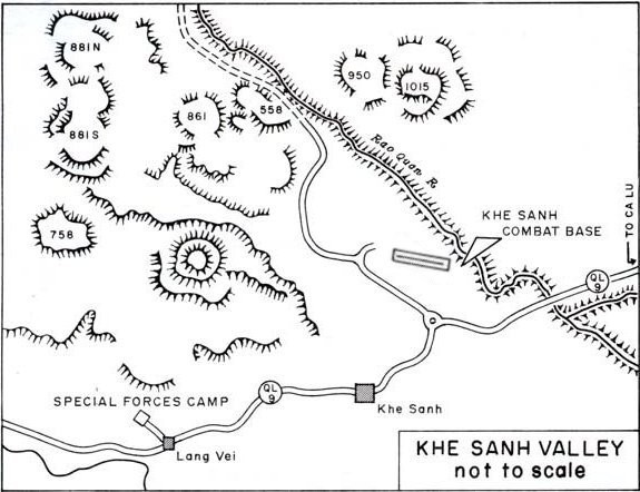 The real terrain. The combat base + airstrip, the hill outposts (881S/N, 861, 558, 950),
Route 9 (QL-9) east to Ca Lu, and the Lang Vei Special Forces camp to the southwest.
Public domain.
The real terrain. The combat base + airstrip, the hill outposts (881S/N, 861, 558, 950),
Route 9 (QL-9) east to Ca Lu, and the Lang Vei Special Forces camp to the southwest.
Public domain.
How the ground maps onto the Caucasus play area:
| Real place | Caucasus CP | Side |
|---|---|---|
| Khe Sanh Combat Base | Kutaisi (0.25 strength — besieged) | BLUE |
| Hill 881S outpost | Hill 881S FOB | BLUE |
| The hills + NVA artillery | Sukhumi | RED |
| Route 9 / Pegasus axis | Senaki | RED |
| Lang Vei (PT-76 armor) | Kobuleti | RED |
| Da Nang (tac-air rear + relief) | Batumi | BLUE |
| Yankee Station carriers | Naval-1 / Naval-2 | BLUE |
| Deep rear (heavy jets, B-52, tanker) | Tbilisi-Lochini | BLUE |
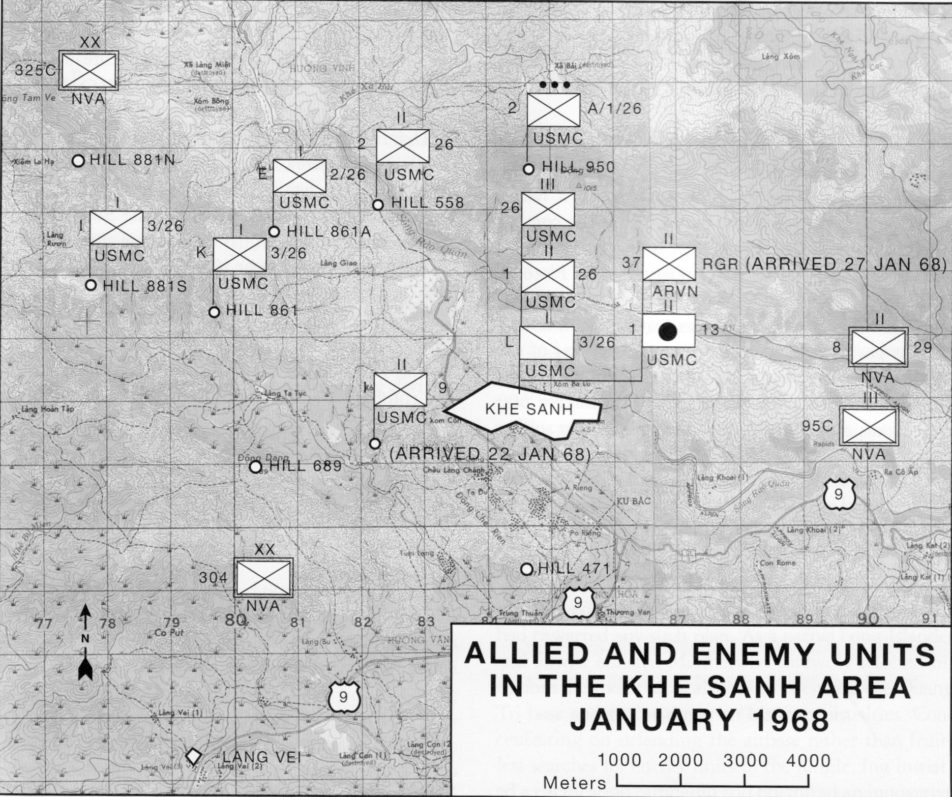 Allied & enemy units, January 1968. The 26th Marines (1/26, 2/26, 3/26) hold the hill
outposts and the base with the ARVN 37th Rangers (arrived 27 Jan), ringed by the NVA 304th,
325C, 320th and 95C divisions and Route-9 approaches. US Navy map (public domain). The campaign's
siege ring (red Sukhumi / Senaki / Kobuleti around blue Kutaisi) abstracts exactly this.
Allied & enemy units, January 1968. The 26th Marines (1/26, 2/26, 3/26) hold the hill
outposts and the base with the ARVN 37th Rangers (arrived 27 Jan), ringed by the NVA 304th,
325C, 320th and 95C divisions and Route-9 approaches. US Navy map (public domain). The campaign's
siege ring (red Sukhumi / Senaki / Kobuleti around blue Kutaisi) abstracts exactly this.
No real MiG threat, no SAMs at the base, no MANPADS (none existed in 1968). You fly against guns — and because there are no missiles, medium altitude is comparatively safe; the men who died flew into the auto-AAA or made repeat passes.
| Threat | Type | The play |
|---|---|---|
| ZSU-23-4 Shilka | radar-directed 23 mm | accurate — terrain-mask, re-attack from a new axis |
| ZSU-57-2 / S-60 | 57 mm (optical) | reaches medium alt — roll in from above, dive, egress jinking |
| ZU-23 + 12.7/14.5 mm | low auto-AAA | lethal low — one pass, vary heading, don't loiter |
| The airstrip approach | the gauntlet | guns range the Khe Sanh strip — suppress before the airlift commits |
| MiG-17F (token) / SA-2 (depth) | — | 🟡 gameplay only — no real MiG/SAM threat at Khe Sanh |
- The artillery — Co Roc 130/152 mm + the hill guns. Air-only target; it does the killing. #1.
- The armor at Lang Vei — PT-76 / T-54. Kill it before it hits the wire.
- Massed infantry / assembly areas — the Arc Light set.
- Approach trenches + the supply road/bridges — interdiction (cut the spans).
- Operation Pegasus — push up Route 9, link up with Khe Sanh, break the siege.
Full target deck + courses of action: intel assessment §VIII.
All imagery is from Wikimedia Commons and is public domain as a work of the U.S. federal government, except the perimeter trenchline (CC BY 2.0, credited). No copyrighted press imagery is used (no AP/UPI/Duncan/Leroy).
| Image | Where used | Author / source | License | Commons file |
|---|---|---|---|---|
| Khe Sanh aerial, 1967 | this page | U.S. Marine Corps | Public domain | 12 - Aerials - Khe Sanh - September 12, 1967 - DPLA - …jpg |
| Khe Sanh valley map | this page | U.S. Government | Public domain | Khe Sanh Area Map.jpg |
| Units, January 1968 | this page | U.S. Navy | Public domain | KhSh9.jpg |
| C-130 on the strip | handbook | U.S. Air Force | Public domain | C-130 Hercules taking off from Khe Sanh 1968.jpg |
| Khe Sanh airstrip | intel assessment | U.S. Air Force | Public domain | Khe Sanh Airport - 1968.jpg |
| LBJ situation-room model | intel assessment | White House — Yoichi Okamoto | Public domain | L B Johnson Model Khe Sanh.jpeg |
| Perimeter trenchline | intel assessment | USMC Archives (Flickr) | CC BY 2.0 | 26 Marines trenchline.jpg |
Files live in the repo at docs/campaigns/img/khe-sanh/; each original is at
https://commons.wikimedia.org/wiki/File:<file name above>.
Maps, aerial, geography, and target priorities are the historical siege mapped to Caucasus; gameplay concessions are flagged 🟡. Full history + read-aloud brief: khe-sanh-intel-assessment.md. Working reference: Campaign Briefing Handbook.
This page is the online copy of docs/campaigns/khe-sanh-visual-briefing.md in the repo. Edit that file; the wiki is mirrored from docs/wiki/ on merge to main.