geographic map

The Geographic-Map of the android app "A Photo Manager" shows markers where photos where taken/geo-tagged. It is also used as geo-picker.
Note: The geograpic data in the map come from openstreetmap servers and is cached on the android device. You need an internet connection to download this map data. To use the map completely offline see Mapsforge offline data below.
You can reach the Geographic-Map via
- the "map filter symbol" (or menu "Map Area Filter") in the Gallery-View
- menu "Show in map" in the Gallery-View or Image-View
- the "location picker" "..." in Filter-View, edit photo properties (exif) and Gallery-View-s toolbar/menu .
- from any filemanager when opening a virtual album file '*.album'.
- from any app that support intents with "geo:"- uris (VIEW/SEND/SENDTO/SEND_MULTIPLE/PICK)
- opening from android-s app manager
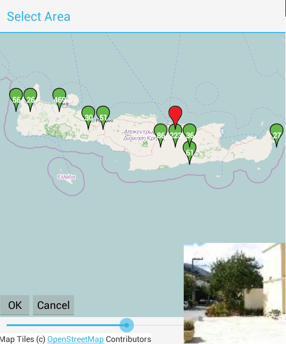
- The geographic map shows markers
 at places where photos were taken.
 - The numer in the green marker indicates how many photos belong to the marker.
-
Blue markers represent selected photos if Gallery-View is in multi selection mode or if SEND_MULTIPLE.
- Note: For performance/memory reason only the first 256 blue markers are shown.
- Note: you can chance this limit in the Settings View under Max. Sel-Markers in Map .
- If you tap on a marker the marker becomes red to indicate current selection and a photo belonging to the marker is displayed in the lower right corner.
- Tap on the photo to hide it.
- if you long-tap on a marker you get a context menu to
- "Show Photo(s)" opens the Image-View filtered by lat/lon of selected marker
- "Show in new Gallery" opens a new Gallery-View instance filtered by lat/lon of selected marker
- to zoom to fit the area of the current marker.
- to open location of current selected photo "in external geo app" (i.e. open with an app that understands "view geo:-uri" like googlemaps, navigation-app, ...)
- If you tap somewhere in the map the "zoomin"- and "zoomout"-buttons become visible to change the map detail level.
- If you double tap somewhere in the map the map zooms in one level.
- If you swipe left/right/up/down you can change the current map area
- The "Zoombar" below the map can be used to change the current zoom level.
- The "Ok" button takes the current visible map area/zoomlevel to update
- which photos are visible if called from the Gallery-View
- lat/lon values in the Filter-View if called from there
- return the current position (red marker) if called from external app via "Pick geo:"
- The "Cancel" button or the back button closes the map without affecting the calling activitry.
- Search commands in Menu (smartphone) or Toolbar (tablet)
-
Searchbar
 : to find Any Text that is contained in eigther folder-path, filename, tags, title, description) New in version 0.7.0
-
Folder Filter or
 opens a Folder-Picker to pick the current Folder.
 -
Date Filter or
 (or menu item "Date Filter") you can open a Date-Picker to pick the current Date range.
 -
Tag Filter or
 (or menu item "Select Tags") you can open a Tag picker to pick included/excluded tags.
 -
Filter opens the Filter-View to define the base filter.
- if Geographic-Map is started without intent-extra-de.k3b.extra.FILTER parameter the map uses the last used filter.
-
Searchbar
Until version 0.5.2 the map data always came from cached online: map data was loaded on demand from the internet and locally stored (cached). If the cache data became to large (depending on available momory between 5 and 50 Megabytes) or to old the least used cache-data was discarded making room for new data. Disadvantage: When your device is offline (not connected to the internet) you can only view map areas that is currently in the cache.
Since Version 0.5.3 Map data can come form two or more locally stored mapsforge-offline files instead. One mapsforge * .map Mapfile contain all data for a certain area in a highly compressed format. The size of a * .map file depends on the covered area and how much detail is in the data.
- world.map 3.1 Megabyte contain only ultra low detail coast line data needed to diplay water/land of the whole world
- germany.map 1.6 Gigabyte ulta high detail data of germany (including single houses with their housenumbers). I also use this file for geocaching, because it is much more detailed than the available online map data.
- greece.map 89 Megabyte low detail data of greece (down to cities with main streets. No houses or small streets)
You have to generate maps on your pc or you can download pregenerated * .map files from the internet (i.e. from http://download.mapsforge.org/maps/) For more details see https://github.com/mapsforge/mapsforge/blob/master/docs/
If you want to use the mapsforge modul
- you have to store the * .map file in the Settings View/Mapsforge Mapsforge offline Folder and
- check [Settings View/Mapsforge]](settings#Mapsforge) Use Mapsforge offline map.
- you should have at least world.map plus any area where you have interest in.
Unchecking Use Mapsforge offline map reverts to "cached online" mode.
If you use the Geographic-Map as a "geo:" picker you can
- tap on a green/blue marker to select the geo-location belonging to that marker (the marker becomes red)
- tap somewhere in the map where no green/blue marker exists to select a place with no photo.
The Intent API support
- action=VIEW/SEND/SENDTO to show map (either with geo uri or uri to '*.album'-file)
- action=PICK to open a "geo:" picker
- mime=" * / * " or mime=null
- geo: uri format (either geo: or file:-albumb required)
- file: to uri '*.album'-file (either geo: or file:-albumb required)
- de.k3b.extra.SELECTED_ITEMS string define the blue markers (optional)
- android.intent.extra.TITLE string (optional)
-
extra[de.k3b.extra.FILTER]
- purpose: Filter the photos that are visible in the map.
See also

