Repository navigation
Map and GPS
Settings > GPS sets the receiver to Off, Intermittent (wakes now and then to save battery) or On. The GPS needs a view of the sky for its first fix, which can take a few minutes.
With a fix, the clock is set from GPS, and your position can be shared:
- Settings > Location Sharing: include your position in your adverts.
- Settings > Telemetry: whether others may ask your device for battery level and position.
The GPS app shows the fix:
- T-Deck: a sky plot of the satellites in view, with position, altitude and time.
- Cardputer: the same information as text.
The Map app shows map tiles from the SD card, with the positions of nodes that share their location.
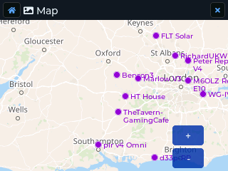
Tiles go on the FAT32 SD card, one folder per style, in the usual
{zoom}/{x}/{y}.png layout:
/maps/osm/day/{z}/{x}/{y}.png      standard OpenStreetMap
/maps/osm/night/{z}/{x}/{y}.png    optional dark style
With the included script (from a copy of the Saitama repository):
python3 scripts/download_tiles.py \
    --output /Volumes/SD/maps/osm \
    --lat 51.5 --lng -0.1 --radius 20 --zoom 10-14
Use your own latitude and longitude. --radius is in kilometres. Stay within the
OpenStreetMap tile usage policy:
the script is limited to 2 requests a second, and large areas at high zoom are a lot
of tiles.
With a GUI tool: map-tiles-downloader.
Export standard OSM tiles and put them under /maps/osm/day.
Settings > Map Style is Day, Night or Auto (the default: night tiles while Night Mode is on). Without night tiles on the card, the day tiles are shown colour-inverted at night, so no extra download is needed.
The Cardputer has its own, lighter map. It reads small JPEG tiles from the SD card (the T-Deck's PNG tiles are too big to decode without PSRAM) and draws them straight to the screen. It shows repeaters (purple), contacts (red) and you (blue), with the zoom level and the map centre on the bottom line. There is no night style.
| Key | Does |
|---|---|
; . , / (arrows) |
Move the map |
= / -
|
Zoom in / out |
c |
Centre on your position |
| Backspace or Esc | Back to the launcher |
With no GPS fix and no manual position, the map opens on the tiles that are on the card, and zoom stops at the levels the card has.
Tiles go on the SD card as:
/maps/osm/{z}/{x}/{y}.jpg
They must be ordinary (baseline) RGB JPEGs, 256 x 256. The included script
scripts/map_tiles_cardputer.py (needs Python 3 and Pillow: pip install pillow)
makes them in a local sdcard/maps folder; copy that maps folder to the root of
the card.
You need a tile provider that allows offline downloads. OpenStreetMap's own server does not: it answers bulk downloads with an "Access blocked" picture, and the script stops when it sees one. We use Thunderforest, which needs an API key, and permits bulk/offline downloading only on its Small Business plan or higher. Create an account, pick the plan, and copy the API key from your Thunderforest dashboard. Keep the key private: don't put it in a file you share or commit.
Download an area around a point (25 km radius by default, zoom 8 to 14):
python3 scripts/map_tiles_cardputer.py --lat 51.50 --lon -3.70 \
    --url "https://tile.thunderforest.com/atlas/{z}/{x}/{y}.png?apikey=YOUR_KEY"
Or a box, south west north east:
python3 scripts/map_tiles_cardputer.py --bounds 49.9 -5.8 52.0 0.5 \
    --url "https://tile.thunderforest.com/atlas/{z}/{x}/{y}.png?apikey=YOUR_KEY"
atlas is a clean style that reads well on the small screen; outdoors (paths and
contours) also works. Add --dry-run first to see how many tiles an area is: every
tile counts against your Thunderforest quota. Southern England and Wales at zoom
8 to 14 is about 59,000 tiles and 125 MB of data (more on the card, as each file
takes at least one cluster). Run the script again to fill any gaps: tiles already
there are skipped.
Already have T-Deck tiles? Convert them with no download:
python3 scripts/map_tiles_cardputer.py --from /Volumes/SD/maps/osm/dayOther options: --radius-km, --min-zoom, --max-zoom, --quality (JPEG quality,
default 60), --out (output folder) and --delay (seconds between downloads).